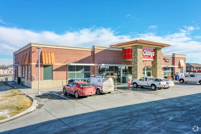
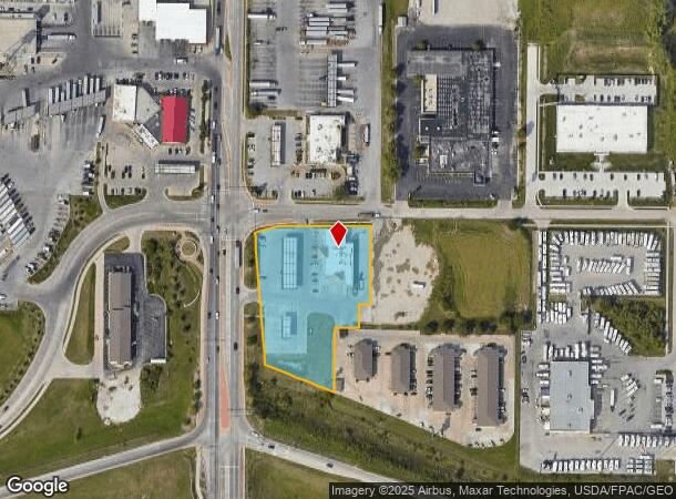
Property Record
2711 S 24Th St, Council Bluffs, IA 51501

NEARBY LISTINGS FOR SALE OR LEASE
Property Detail
2711 S 24Th St
Omaha-Council Bluffs, NE-IA
Railroad Addition Replat 1
7444 02 352 014
RAILROAD ADD REPLAT 1 LTS 1 & 2
Conveniencestore
Pottawattamie
X
Iowa
31153C0085G
1,2
2025
2.38 AC
2025
Downtown Council Bluffs
031300
Omaha/Council Bluffs
DEMOGRAPHICS near 2711 S 24Th St
1 Mile
3 Mile
5 Mile
2024 Total Population
2,960
53,184
155,903
2029 Population
2,935
53,386
157,868
Pop Growth 2024-2029
(0.84%)
+ 0.38%
+ 1.26%
Average Age
40
39
37
2024 Total Households
1,157
21,933
61,209
HH Growth 2024-2029
(0.78%)
+ 0.45%
+ 1.44%
Median Household Inc
$44,683
$53,713
$52,630
Avg Household Size
2.50
2.30
2.30
2024 Avg HH Vehicles
2.00
2.00
2.00
Median Home Value
$95,021
$141,615
$161,411
Median Year Built
1991
1956
1957
Nearby Places
Map Layers
Map Styles
 Street
 Aerial
- Restaurants
- Banks
- Shops
- Fitness
- Groceries
PUBLIC TRANSPORTATION
COMMUTER RAIL
Omaha Amtrak Station (California Zephyr - Amtrak)
DRIVE
WALK
Distance
Omaha Amtrak Station (California Zephyr - Amtrak)
9 min
4.6 mi
Omaha Amtrak Station (California Zephyr - Amtrak)
DRIVE
WALK
Distance
Omaha Amtrak Station (California Zephyr - Amtrak)
9 min
4.7 mi
AIRPORT
Eppley Airfield
DRIVE
WALK
Distance
Eppley Airfield
17 min
7.9 mi
Freight Ports
Tulsa Port Of Catoosa
DRIVE
WALK
Distance
Tulsa Port Of Catoosa
456 min
414.4 mi
Nearby Properties
Address
Land Use
TOTAL SIZE
Lot Size
Zoning
Address
Land Use
TOTAL SIZE
Lot Size
Zoning
62.66 AC
P-C
Address
Land Use
TOTAL SIZE
Lot Size
Zoning
36.26 AC
P-C
Address
Land Use
TOTAL SIZE
Lot Size
Zoning
534,110 SF
4.35 AC
Address
Land Use
TOTAL SIZE
Lot Size
Zoning
30.39 AC
P-C
Address
Land Use
TOTAL SIZE
Lot Size
Zoning
52.44 AC
I-2
Address
Land Use
TOTAL SIZE
Lot Size
Zoning
16.18 AC
P-C
Address
Land Use
TOTAL SIZE
Lot Size
Zoning
50.56 AC
I-1
Address
Land Use
TOTAL SIZE
Lot Size
Zoning
346,816 SF
0.80 AC
Address
Land Use
TOTAL SIZE
Lot Size
Zoning
318,392 SF
7.77 AC
Address
Land Use
TOTAL SIZE
Lot Size
Zoning
4.22 AC
R-4
Address
Land Use
TOTAL SIZE
Lot Size
Zoning
319,440 SF
3.05 AC
Address
Land Use
TOTAL SIZE
Lot Size
Zoning
27.38 AC
I-2
Address
Land Use
TOTAL SIZE
Lot Size
Zoning
10.91 AC
R-3
Address
Land Use
TOTAL SIZE
Lot Size
Zoning
149,737 SF
1.93 AC
Address
Land Use
TOTAL SIZE
Lot Size
Zoning
42.97 AC
I-2
Address
Land Use
TOTAL SIZE
Lot Size
Zoning
16.87 AC
P-C
Address
Land Use
TOTAL SIZE
Lot Size
Zoning
68.36 AC
R-1M
Address
Land Use
TOTAL SIZE
Lot Size
Zoning
98,202 SF
17.88 AC
P-C
Address
Land Use
TOTAL SIZE
Lot Size
Zoning
2.91 AC
A-P
Address
Land Use
TOTAL SIZE
Lot Size
Zoning
0.89 AC
P-C
Address
Land Use
TOTAL SIZE
Lot Size
Zoning
37.25 AC
I-2
Address
Land Use
TOTAL SIZE
Lot Size
Zoning
15.96 AC
I-2
Address
Land Use
TOTAL SIZE
Lot Size
Zoning
20 AC
I-2
Address
Land Use
TOTAL SIZE
Lot Size
Zoning
11.10 AC
R-3
Address
Land Use
TOTAL SIZE
Lot Size
Zoning
3,552 SF
18.50 AC
I-2
Address
Land Use
TOTAL SIZE
Lot Size
Zoning
22.91 AC
A-P
Address
Land Use
TOTAL SIZE
Lot Size
Zoning
105,193 SF
1.52 AC
Address
Land Use
TOTAL SIZE
Lot Size
Zoning
174,726 SF
4.33 AC
Address
Land Use
TOTAL SIZE
Lot Size
Zoning
1.99 AC
C-3
Address
Land Use
TOTAL SIZE
Lot Size
Zoning
21.72 AC
I-2
The World's #1 Commercial Real Estate Marketplace
Connect with us
© 2025 CoStar Group
The information above has been obtained from sources believed reliable. While we do not doubt its accuracy we have not verified it and make no guarantee, warranty or representation about it. It is your responsibility to independently confirm its accuracy and completeness. Any projections, opinions, assumptions, or estimates used are for example only and do not represent the current or future performance of the property. The value of this transaction to you depends on tax and other factors which should be evaluated by your tax, financial, and legal advisors. You and your advisors should conduct a careful, independent investigation of the property to determine to your satisfaction the suitability of the property for your needs.