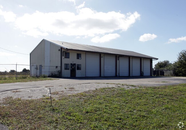
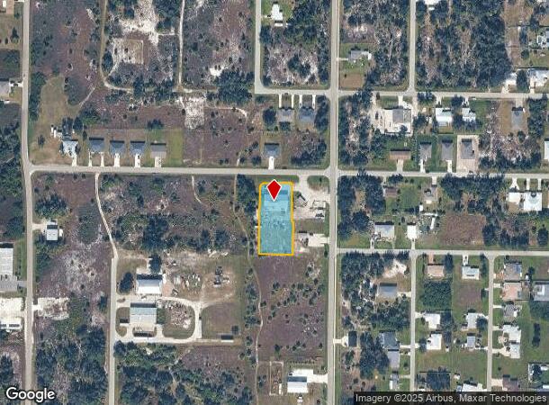
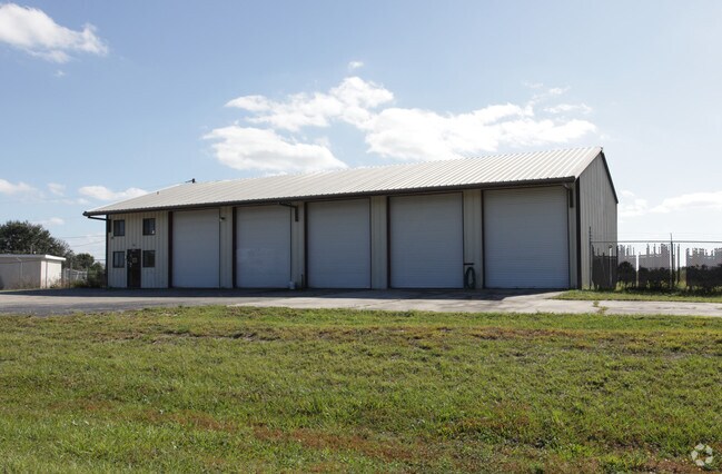
Property Record
27131 Adams St, Punta Gorda, FL 33983
NEARBY LISTINGS FOR SALE OR LEASE
Property Detail
27131 Adams St
Punta Gorda, FL
Hrbr Hts
402315356001
HRBR HTS SEC 5 BLK 31 LTS 40 & 41 & 42 85/21 1014/1844 2602/2026 CT3474/314 3501/2167 RES4412/622 HBH 005 0031 0043 HRBR HTS SEC 5 BLK 31 LTS 43 & 44 348/963 415/58 415/90 524/517 758/376-396 823/1004 826/96 995/2049 2602/2026
Warehouse
Charlotte
X
Florida
12015C0232G
40
2024
0.81 AC
2025
Charlotte County
021001
Southwest Florida
4,560 SF
DEMOGRAPHICS near 27131 Adams St
1 Mile
3 Mile
5 Mile
2024 Total Population
3,135
25,486
56,878
2029 Population
3,745
30,755
67,970
Pop Growth 2024-2029
+ 19.46%
+ 20.67%
+ 19.50%
Average Age
49
53
51
2024 Total Households
1,363
11,808
26,037
HH Growth 2024-2029
+ 19.59%
+ 21.00%
+ 19.86%
Median Household Inc
$66,796
$54,073
$54,678
Avg Household Size
2.20
2.10
2.10
2024 Avg HH Vehicles
2.00
2.00
2.00
Median Home Value
$278,413
$239,758
$227,436
Median Year Built
1988
1994
1990
Nearby Places
Map Layers
Map Styles
 Street
 Aerial
- Restaurants
- Banks
- Shops
- Fitness
- Groceries
PUBLIC TRANSPORTATION
AIRPORT
Punta Gorda
DRIVE
WALK
Distance
Punta Gorda
14 min
8.3 mi
Freight Ports
Port Manatee
DRIVE
WALK
Distance
Port Manatee
82 min
69.1 mi
Nearby Properties
Address
Land Use
TOTAL SIZE
Lot Size
Zoning
Address
Land Use
TOTAL SIZE
Lot Size
Zoning
121,585 SF
696.03 AC
RE1
Address
Land Use
TOTAL SIZE
Lot Size
Zoning
249,777 SF
48 AC
RMF10
Address
Land Use
TOTAL SIZE
Lot Size
Zoning
254.31 AC
PD
Address
Land Use
TOTAL SIZE
Lot Size
Zoning
125.54 AC
PD
Address
Land Use
TOTAL SIZE
Lot Size
Zoning
84,500 SF
5.59 AC
CG
Address
Land Use
TOTAL SIZE
Lot Size
Zoning
116,186 SF
20.02 AC
RMF10
Address
Land Use
TOTAL SIZE
Lot Size
Zoning
98,552 SF
11.42 AC
CG
Address
Land Use
TOTAL SIZE
Lot Size
Zoning
66,461 SF
10.86 AC
CG
Address
Land Use
TOTAL SIZE
Lot Size
Zoning
51,248 SF
15.96 AC
PD
Address
Land Use
TOTAL SIZE
Lot Size
Zoning
2,148 SF
121.95 AC
PD
Address
Land Use
TOTAL SIZE
Lot Size
Zoning
1,556 SF
23.08 AC
CG
Address
Land Use
TOTAL SIZE
Lot Size
Zoning
81,226 SF
11.40 AC
OMI
Address
Land Use
TOTAL SIZE
Lot Size
Zoning
34,983 SF
18.79 AC
RE1
Address
Land Use
TOTAL SIZE
Lot Size
Zoning
60.56 AC
PD
Address
Land Use
TOTAL SIZE
Lot Size
Zoning
74,434 SF
4.42 AC
CG
Address
Land Use
TOTAL SIZE
Lot Size
Zoning
23,566 SF
20.33 AC
RMF10
Address
Land Use
TOTAL SIZE
Lot Size
Zoning
31,194 SF
7.93 AC
CG
Address
Land Use
TOTAL SIZE
Lot Size
Zoning
106.30 AC
PD
Address
Land Use
TOTAL SIZE
Lot Size
Zoning
34,159 SF
23.55 AC
PD
Address
Land Use
TOTAL SIZE
Lot Size
Zoning
14,945 SF
2.47 AC
RMF15
Address
Land Use
TOTAL SIZE
Lot Size
Zoning
11,248 SF
91.25 AC
RMF15
Address
Land Use
TOTAL SIZE
Lot Size
Zoning
22,306 SF
1.97 AC
CG
Address
Land Use
TOTAL SIZE
Lot Size
Zoning
32,938 SF
9.62 AC
RE1
Address
Land Use
TOTAL SIZE
Lot Size
Zoning
24,020 SF
13.35 AC
II
Address
Land Use
TOTAL SIZE
Lot Size
Zoning
28.40 AC
PD
Address
Land Use
TOTAL SIZE
Lot Size
Zoning
66,050 SF
7.74 AC
CG
Address
Land Use
TOTAL SIZE
Lot Size
Zoning
8,750 SF
21.19 AC
CG
Address
Land Use
TOTAL SIZE
Lot Size
Zoning
9,368 SF
2.80 AC
RE1
Address
Land Use
TOTAL SIZE
Lot Size
Zoning
2,400 SF
1.65 AC
IG
Address
Land Use
TOTAL SIZE
Lot Size
Zoning
23.31 AC
CG
The World's #1 Commercial Real Estate Marketplace
Connect with us
© 2026 CoStar Group
The information above has been obtained from sources believed reliable. While we do not doubt its accuracy we have not verified it and make no guarantee, warranty or representation about it. It is your responsibility to independently confirm its accuracy and completeness. Any projections, opinions, assumptions, or estimates used are for example only and do not represent the current or future performance of the property. The value of this transaction to you depends on tax and other factors which should be evaluated by your tax, financial, and legal advisors. You and your advisors should conduct a careful, independent investigation of the property to determine to your satisfaction the suitability of the property for your needs.