Property Record
272 Kryder Ave, Akron, OH 44305
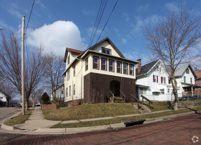

Property Detail
272 Kryder Ave
Akron, OH
BLUE POND LOT 63 ALL
68-28258
Summit
Apartment
Ohio
B and X Area of moderate flood hazard, usually the area between the limits of the 100-year and 500-year floods.
63
2023
0.10 AC
2025
Goodyear Heights
502600
Cleveland
2,485 SF
NEARBY LISTINGS FOR SALE OR LEASE
DEMOGRAPHICS near 272 Kryder Ave
1 mile
3 mile
5 mile
2025 Total Population
12,862
95,136
217,078
2030 Population
12,973
95,622
217,626
Pop Growth 2025-2030
+ 0.86%
+ 0.51%
+ 0.25%
Average Age
38
38
40
2025 Total Households
5,429
39,542
93,200
HH Growth 2025-2030
+ 0.81%
+ 0.48%
+ 0.21%
Median Household Inc
$48,689
$46,334
$50,819
Avg Household Size
2.30
2.20
2.20
2025 Avg HH Vehicles
2.00
1.00
2.00
Median Home Value
$73,462
$117,300
$142,703
Median Year Built
1947
1954
1954
Nearby Places
Map Layers
Map Styles
 Street
 Aerial
Layers
 Traffic
 Biking
Places
Listings with unknown addresses are not visible on the map
- Restaurants
- Banks
- Shops
- Fitness
- Groceries
PUBLIC TRANSPORTATION
COMMUTER RAIL
Drive
Walk
Distance
9 min
2.9 mi
Drive
Walk
Distance
16 min
6.3 mi
AIRPORT
Akron-Canton Regional
Drive
Walk
Distance
Akron-Canton Regional
21 min
14.0 mi
Cleveland-Hopkins International
Drive
Walk
Distance
Cleveland-Hopkins International
61 min
42.9 mi
Nearby Properties
Address
Land Use
TOTAL SIZE
Lot Size
Zoning
Address
Land Use
TOTAL SIZE
Lot Size
Zoning
1,004,220 SF
3.84 AC
Address
Land Use
TOTAL SIZE
Lot Size
Zoning
148,212 SF
2.84 AC
Address
Land Use
TOTAL SIZE
Lot Size
Zoning
Address
Land Use
TOTAL SIZE
Lot Size
Zoning
348,519 SF
7.45 AC
Address
Land Use
TOTAL SIZE
Lot Size
Zoning
472,380 SF
4.55 AC
Address
Land Use
TOTAL SIZE
Lot Size
Zoning
225,751 SF
0.16 AC
Address
Land Use
TOTAL SIZE
Lot Size
Zoning
404,207 SF
2.19 AC
Address
Land Use
TOTAL SIZE
Lot Size
Zoning
203,458 SF
10.41 AC
Address
Land Use
TOTAL SIZE
Lot Size
Zoning
264,753 SF
22.87 AC
Address
Land Use
TOTAL SIZE
Lot Size
Zoning
92,152 SF
1.69 AC
Address
Land Use
TOTAL SIZE
Lot Size
Zoning
121,738 SF
1.60 AC
Address
Land Use
TOTAL SIZE
Lot Size
Zoning
Address
Land Use
TOTAL SIZE
Lot Size
Zoning
Address
Land Use
TOTAL SIZE
Lot Size
Zoning
3.15 AC
Address
Land Use
TOTAL SIZE
Lot Size
Zoning
257,958 SF
4.64 AC
Address
Land Use
TOTAL SIZE
Lot Size
Zoning
186,867 SF
1.48 AC
Address
Land Use
TOTAL SIZE
Lot Size
Zoning
423,125 SF
5.57 AC
Address
Land Use
TOTAL SIZE
Lot Size
Zoning
0.41 AC
Address
Land Use
TOTAL SIZE
Lot Size
Zoning
183,227 SF
4.29 AC
Address
Land Use
TOTAL SIZE
Lot Size
Zoning
347,139 SF
9.65 AC
Address
Land Use
TOTAL SIZE
Lot Size
Zoning
51,702 SF
0.36 AC
Address
Land Use
TOTAL SIZE
Lot Size
Zoning
3.16 AC
Address
Land Use
TOTAL SIZE
Lot Size
Zoning
66,302 SF
10.87 AC
Address
Land Use
TOTAL SIZE
Lot Size
Zoning
52,803 SF
1.33 AC
Address
Land Use
TOTAL SIZE
Lot Size
Zoning
275,025 SF
0.98 AC
Address
Land Use
TOTAL SIZE
Lot Size
Zoning
118,928 SF
1.15 AC
Address
Land Use
TOTAL SIZE
Lot Size
Zoning
232,791 SF
8.16 AC
Address
Land Use
TOTAL SIZE
Lot Size
Zoning
210,474 SF
1.87 AC
Address
Land Use
TOTAL SIZE
Lot Size
Zoning
215,975 SF
5.76 AC
Address
Land Use
TOTAL SIZE
Lot Size
Zoning
245,911 SF
14.48 AC
The World's #1 Commercial Real Estate Marketplace
Connect with us
© 2026 CoStar Group
The information above has been obtained from sources believed reliable. While we do not doubt its accuracy we have not verified it and make no guarantee, warranty or representation about it. It is your responsibility to independently confirm its accuracy and completeness. Any projections, opinions, assumptions, or estimates used are for example only and do not represent the current or future performance of the property. The value of this transaction to you depends on tax and other factors which should be evaluated by your tax, financial, and legal advisors. You and your advisors should conduct a careful, independent investigation of the property to determine to your satisfaction the suitability of the property for your needs.