Property Record
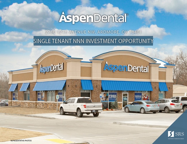
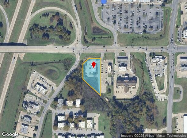
2730 12Th Ave Nw, Ardmore, OK 73401
NEARBY LISTINGS FOR SALE OR LEASE
Property Detail
2730 12Th Ave Nw
0026-00-000-001-0-001-00
Ardmore Crossing Addn
Medicalbuilding
ARDMORE CROSSING ADDN RE-PLAT OF BLK 1 LOT 3, LOT 1 (IRREG)
X
Carter
40019C0445C
Oklahoma
2024
1,3
2025
1.27 AC
893002
Other Market Areas
3,250 SF
Ardmore, OK
DEMOGRAPHICS near 2730 12Th Ave Nw
1 Mile
3 Mile
5 Mile
2024 Total Population
2,635
24,166
29,775
2029 Population
2,706
24,961
30,683
Pop Growth 2024-2029
+ 2.69%
+ 3.29%
+ 3.05%
Average Age
42
41
41
2024 Total Households
1,128
9,759
11,828
HH Growth 2024-2029
+ 2.57%
+ 3.23%
+ 3.02%
Median Household Inc
$45,872
$48,058
$51,067
Avg Household Size
2.20
2.30
2.40
2024 Avg HH Vehicles
2.00
2.00
2.00
Median Home Value
$148,031
$141,836
$152,438
Median Year Built
1979
1968
1972
Nearby Places
Map Layers
Map Styles
 Street
 Aerial
- Restaurants
- Banks
- Shops
- Fitness
- Groceries
PUBLIC TRANSPORTATION
COMMUTER RAIL
Ardmore Amtrak Station (Heartland Flyer - Amtrak)
DRIVE
WALK
Distance
Ardmore Amtrak Station (Heartland Flyer - Amtrak)
6 min
3.2 mi
Freight Ports
Tulsa Port of Inola
DRIVE
WALK
Distance
Tulsa Port of Inola
235 min
203.4 mi
SALE & LEASE HISTORY
LISTING DATE
SALE/LEASE

May 14, 2019
For Sale
Nearby Properties
Address
Land Use
TOTAL SIZE
Lot Size
Zoning
Address
Land Use
TOTAL SIZE
Lot Size
Zoning
2,565 SF
5.42 AC
C1
Address
Land Use
TOTAL SIZE
Lot Size
Zoning
3,090 SF
17.88 AC
Address
Land Use
TOTAL SIZE
Lot Size
Zoning
15,336 SF
108.27 AC
C1
Address
Land Use
TOTAL SIZE
Lot Size
Zoning
720 SF
115.99 AC
C1
Address
Land Use
TOTAL SIZE
Lot Size
Zoning
1,134 SF
4.03 AC
C1
Address
Land Use
TOTAL SIZE
Lot Size
Zoning
120 SF
1.80 AC
C1
Address
Land Use
TOTAL SIZE
Lot Size
Zoning
2,859 SF
1.94 AC
C1
Address
Land Use
TOTAL SIZE
Lot Size
Zoning
2,018 SF
12.23 AC
Address
Land Use
TOTAL SIZE
Lot Size
Zoning
1,593 SF
10.52 AC
C1
Address
Land Use
TOTAL SIZE
Lot Size
Zoning
6,148 SF
3.34 AC
C1
Address
Land Use
TOTAL SIZE
Lot Size
Zoning
3,655 SF
4.90 AC
C1
Address
Land Use
TOTAL SIZE
Lot Size
Zoning
6,348 SF
7.69 AC
C1
Address
Land Use
TOTAL SIZE
Lot Size
Zoning
5,290 SF
2.75 AC
C1
Address
Land Use
TOTAL SIZE
Lot Size
Zoning
27,476 SF
12.53 AC
C1
Address
Land Use
TOTAL SIZE
Lot Size
Zoning
44,073 SF
17.07 AC
C1
Address
Land Use
TOTAL SIZE
Lot Size
Zoning
62,600 SF
5.15 AC
Address
Land Use
TOTAL SIZE
Lot Size
Zoning
3,188 SF
2.75 AC
C1
Address
Land Use
TOTAL SIZE
Lot Size
Zoning
1,225 SF
4.36 AC
C1
Address
Land Use
TOTAL SIZE
Lot Size
Zoning
4,294 SF
2.56 AC
C1
Address
Land Use
TOTAL SIZE
Lot Size
Zoning
1,040 SF
38.87 AC
C1
Address
Land Use
TOTAL SIZE
Lot Size
Zoning
264 SF
5.38 AC
C1
Address
Land Use
TOTAL SIZE
Lot Size
Zoning
18,185 SF
3.65 AC
C1
Address
Land Use
TOTAL SIZE
Lot Size
Zoning
1,479 SF
2.33 AC
C1
Address
Land Use
TOTAL SIZE
Lot Size
Zoning
224 SF
6.98 AC
C1
Address
Land Use
TOTAL SIZE
Lot Size
Zoning
11,856 SF
5.63 AC
R1
Address
Land Use
TOTAL SIZE
Lot Size
Zoning
60 SF
10.72 AC
C1
Address
Land Use
TOTAL SIZE
Lot Size
Zoning
41,201 SF
6.96 AC
C1
Address
Land Use
TOTAL SIZE
Lot Size
Zoning
408 SF
2.76 AC
Address
Land Use
TOTAL SIZE
Lot Size
Zoning
3,167 SF
2.73 AC
C1
Address
Land Use
TOTAL SIZE
Lot Size
Zoning
18,153 SF
6.51 AC
The World's #1 Commercial Real Estate Marketplace
Connect with us
© 2026 CoStar Group
The information above has been obtained from sources believed reliable. While we do not doubt its accuracy we have not verified it and make no guarantee, warranty or representation about it. It is your responsibility to independently confirm its accuracy and completeness. Any projections, opinions, assumptions, or estimates used are for example only and do not represent the current or future performance of the property. The value of this transaction to you depends on tax and other factors which should be evaluated by your tax, financial, and legal advisors. You and your advisors should conduct a careful, independent investigation of the property to determine to your satisfaction the suitability of the property for your needs.