Property Record
2732 S 11Th St, Niles, MI 49120
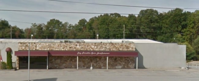
This Property Is For Sale
NEARBY LISTINGS FOR SALE OR LEASE
Property Detail
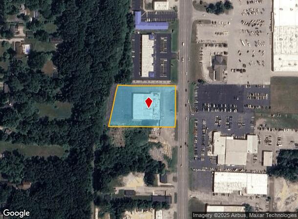
2732 S 11Th St
11-14-0860-0056-05-9
Addition To Bertrand
Bowlingalley
PT OF BLKS 50 51 55 & 56 VILLAGE OF BERTRAND PLAT OF 1836 DESC AS COM AT S1/4 PST SEC 14 T8S R17W TH E 1093.15' TH N01DEG16'W 1143.65' TO POB TH S88DEG51'W 400.10' TO E R/W LN MCRR TH N10DEG22'E 247.00' TH N88DEG51'E 350.5' TH S01DEG16'E 242' TO POB
X
Berrien
18141C0070D
Michigan
2024
2.09 AC
2025
Michigan Southwest Area
021100
Other Market Areas
24,148 SF
Niles, MI
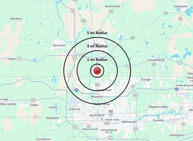
DEMOGRAPHICS near 2732 S 11Th St
1 Mile
3 Mile
5 Mile
2024 Total Population
3,095
20,493
68,411
2029 Population
3,020
20,139
67,396
Pop Growth 2024-2029
(2.42%)
(1.73%)
(1.48%)
Average Age
43
43
41
2024 Total Households
1,195
8,223
26,729
HH Growth 2024-2029
(2.68%)
(1.85%)
(1.63%)
Median Household Inc
$57,572
$81,506
$69,741
Avg Household Size
2.30
2.40
2.30
2024 Avg HH Vehicles
2.00
2.00
2.00
Median Home Value
$141,065
$182,832
$177,135
Median Year Built
1958
1974
1972
Nearby Places
Map Layers
Map Styles
 Street
 Aerial
- Restaurants
- Banks
- Shops
- Fitness
- Groceries
PUBLIC TRANSPORTATION
COMMUTER RAIL
DRIVE
WALK
Distance
9 min
4.9 mi
South Bend Airport Station (South Shore Line - Northern Indiana Commuter Transportation District (South Shore Line))
DRIVE
WALK
Distance
South Bend Airport Station (South Shore Line - Northern Indiana Commuter Transportation District (South Shore Line))
19 min
8.5 mi
AIRPORT
South Bend International
DRIVE
WALK
Distance
South Bend International
29 min
11.5 mi
Nearby Properties
Address
Land Use
TOTAL SIZE
Lot Size
Zoning
Address
Land Use
TOTAL SIZE
Lot Size
Zoning
157,702 SF
44 SF
Address
Land Use
TOTAL SIZE
Lot Size
Zoning
63,780 SF
44 SF
Address
Land Use
TOTAL SIZE
Lot Size
Zoning
33,936 SF
1.84 AC
GB
Address
Land Use
TOTAL SIZE
Lot Size
Zoning
164,768 SF
24.57 AC
GB
Address
Land Use
TOTAL SIZE
Lot Size
Zoning
215,252 SF
18.33 AC
Address
Land Use
TOTAL SIZE
Lot Size
Zoning
41,512 SF
1.37 AC
Address
Land Use
TOTAL SIZE
Lot Size
Zoning
135,152 SF
8.76 AC
GB
Address
Land Use
TOTAL SIZE
Lot Size
Zoning
58,646 SF
1 AC
Address
Land Use
TOTAL SIZE
Lot Size
Zoning
93,452 SF
44 SF
Address
Land Use
TOTAL SIZE
Lot Size
Zoning
300,000 SF
65.30 AC
I
Address
Land Use
TOTAL SIZE
Lot Size
Zoning
26,140 SF
131 SF
Address
Land Use
TOTAL SIZE
Lot Size
Zoning
49,914 SF
6.18 AC
GB
Address
Land Use
TOTAL SIZE
Lot Size
Zoning
52,528 SF
2.41 AC
Address
Land Use
TOTAL SIZE
Lot Size
Zoning
42,210 SF
15.08 AC
Address
Land Use
TOTAL SIZE
Lot Size
Zoning
23,208 SF
44 SF
Address
Land Use
TOTAL SIZE
Lot Size
Zoning
61,402 SF
2.49 AC
MDR
Address
Land Use
TOTAL SIZE
Lot Size
Zoning
35,016 SF
3.50 AC
Address
Land Use
TOTAL SIZE
Lot Size
Zoning
5,075 SF
36.90 AC
R-3
Address
Land Use
TOTAL SIZE
Lot Size
Zoning
19,626 SF
3.10 AC
GB
Address
Land Use
TOTAL SIZE
Lot Size
Zoning
22,657 SF
44 SF
Address
Land Use
TOTAL SIZE
Lot Size
Zoning
42,840 SF
1.65 AC
GB
Address
Land Use
TOTAL SIZE
Lot Size
Zoning
24,984 SF
5 AC
R-2
Address
Land Use
TOTAL SIZE
Lot Size
Zoning
31,932 SF
0.90 AC
RC
Address
Land Use
TOTAL SIZE
Lot Size
Zoning
14,487 SF
2.43 AC
GB
Address
Land Use
TOTAL SIZE
Lot Size
Zoning
48,100 SF
5.10 AC
GB
Address
Land Use
TOTAL SIZE
Lot Size
Zoning
113,964 SF
9.85 AC
GB
Address
Land Use
TOTAL SIZE
Lot Size
Zoning
61,128 SF
7.63 AC
GB
Address
Land Use
TOTAL SIZE
Lot Size
Zoning
2,580 SF
70.66 AC
Address
Land Use
TOTAL SIZE
Lot Size
Zoning
77,338 SF
7.98 AC
Address
Land Use
TOTAL SIZE
Lot Size
Zoning
58,381 SF
5.92 AC
GB
The World's #1 Commercial Real Estate Marketplace
Connect with us
© 2026 CoStar Group
The information above has been obtained from sources believed reliable. While we do not doubt its accuracy we have not verified it and make no guarantee, warranty or representation about it. It is your responsibility to independently confirm its accuracy and completeness. Any projections, opinions, assumptions, or estimates used are for example only and do not represent the current or future performance of the property. The value of this transaction to you depends on tax and other factors which should be evaluated by your tax, financial, and legal advisors. You and your advisors should conduct a careful, independent investigation of the property to determine to your satisfaction the suitability of the property for your needs.