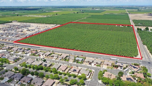
Property Record
275 N Del Norte Ave, Kerman, CA 93630
NEARBY LISTINGS FOR SALE OR LEASE
Property Detail
275 N Del Norte Ave
Fresno, CA
Fresno Irrigated Farms Co
020-120-30S
24.24 AC SUR RT IN LT 15 16 19 20 F I FRM CO SEC 1
Sfr
Fresno
X
California
06019C2075H
16
2025
24.24 AC
2025
W Outlying Fresno County
004004
Fresno
955 SF
DEMOGRAPHICS near 275 N Del Norte Ave
1 mile
3 mile
5 mile
2024 Total Population
9,238
18,124
19,983
2029 Population
9,519
18,495
20,274
Pop Growth 2024-2029
+ 3.04%
+ 2.05%
+ 1.46%
Average Age
34
34
34
2024 Total Households
2,555
5,029
5,588
HH Growth 2024-2029
+ 3.01%
+ 2.01%
+ 1.36%
Median Household Inc
$65,739
$60,693
$62,014
Avg Household Size
3.60
3.60
3.60
2024 Avg HH Vehicles
2.00
2.00
2.00
Median Home Value
$286,859
$278,106
$286,049
Median Year Built
1996
1992
1991
Nearby Places
Map Layers
Map Styles
 Street
 Aerial
Transit
 Traffic
 Biking
Places
Listings with unknown addresses are not visible on the map
- Restaurants
- Banks
- Shops
- Fitness
- Groceries
PUBLIC TRANSPORTATION
AIRPORT
Fresno Yosemite International
Drive
Walk
Distance
Fresno Yosemite International
31 min
21.3 mi
Freight Ports
Port of Stockton
Drive
Walk
Distance
Port of Stockton
151 min
121.9 mi
SALE & LEASE HISTORY
LISTING DATE
SALE/LEASE

Nov 10, 2022
For Sale
Nearby Properties
Address
Land Use
TOTAL SIZE
Lot Size
Zoning
Address
Land Use
TOTAL SIZE
Lot Size
Zoning
477,340 SF
21.45 AC
Address
Land Use
TOTAL SIZE
Lot Size
Zoning
151,227 SF
17.22 AC
C6
Address
Land Use
TOTAL SIZE
Lot Size
Zoning
29,746 SF
39.10 AC
AE20
Address
Land Use
TOTAL SIZE
Lot Size
Zoning
65,017 SF
4.38 AC
R2
Address
Land Use
TOTAL SIZE
Lot Size
Zoning
82,656 SF
6.76 AC
R2
Address
Land Use
TOTAL SIZE
Lot Size
Zoning
63,187 SF
3.87 AC
R3
Address
Land Use
TOTAL SIZE
Lot Size
Zoning
63,187 SF
3.90 AC
R3
Address
Land Use
TOTAL SIZE
Lot Size
Zoning
92,979 SF
5.73 AC
R1
Address
Land Use
TOTAL SIZE
Lot Size
Zoning
90,082 SF
9.12 AC
C2
Address
Land Use
TOTAL SIZE
Lot Size
Zoning
364 SF
11.88 AC
R3
Address
Land Use
TOTAL SIZE
Lot Size
Zoning
70,786 SF
5.46 AC
SDR2
Address
Land Use
TOTAL SIZE
Lot Size
Zoning
16,000 SF
2.08 AC
Address
Land Use
TOTAL SIZE
Lot Size
Zoning
28.36 AC
M2
Address
Land Use
TOTAL SIZE
Lot Size
Zoning
69,820 SF
19.72 AC
Address
Land Use
TOTAL SIZE
Lot Size
Zoning
16,834 SF
0.96 AC
CG
Address
Land Use
TOTAL SIZE
Lot Size
Zoning
18,340 SF
1.21 AC
CG
Address
Land Use
TOTAL SIZE
Lot Size
Zoning
64,484 SF
13.62 AC
M1
Address
Land Use
TOTAL SIZE
Lot Size
Zoning
129,750 SF
12.52 AC
M2
Address
Land Use
TOTAL SIZE
Lot Size
Zoning
13,225 SF
1.67 AC
C5
Address
Land Use
TOTAL SIZE
Lot Size
Zoning
99.62 AC
Address
Land Use
TOTAL SIZE
Lot Size
Zoning
166,410 SF
9.80 AC
M2
Address
Land Use
TOTAL SIZE
Lot Size
Zoning
35,160 SF
3.45 AC
RM
Address
Land Use
TOTAL SIZE
Lot Size
Zoning
31,484 SF
3.03 AC
R2
Address
Land Use
TOTAL SIZE
Lot Size
Zoning
15,447 SF
1.95 AC
Address
Land Use
TOTAL SIZE
Lot Size
Zoning
1,189 SF
29.71 AC
AE20
Address
Land Use
TOTAL SIZE
Lot Size
Zoning
1.02 AC
C5
Address
Land Use
TOTAL SIZE
Lot Size
Zoning
1,720 SF
20 AC
AE20
Address
Land Use
TOTAL SIZE
Lot Size
Zoning
5,161 SF
79.01 AC
AE20
Address
Land Use
TOTAL SIZE
Lot Size
Zoning
4,416 SF
80 AC
AE20
The World's #1 Commercial Real Estate Marketplace
Connect with us
© 2026 CoStar Group
The information above has been obtained from sources believed reliable. While we do not doubt its accuracy we have not verified it and make no guarantee, warranty or representation about it. It is your responsibility to independently confirm its accuracy and completeness. Any projections, opinions, assumptions, or estimates used are for example only and do not represent the current or future performance of the property. The value of this transaction to you depends on tax and other factors which should be evaluated by your tax, financial, and legal advisors. You and your advisors should conduct a careful, independent investigation of the property to determine to your satisfaction the suitability of the property for your needs.