Property Record
2801 Emrick Blvd, Bethlehem, PA 18020

NEARBY LISTINGS FOR SALE OR LEASE
Property Detail
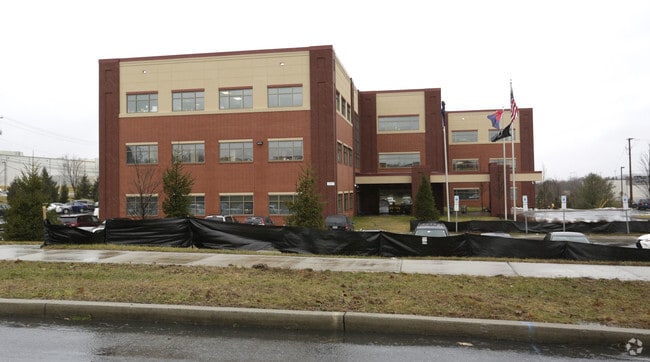
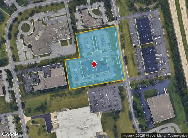
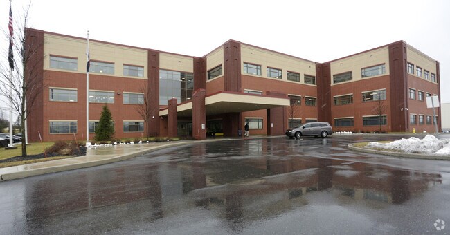
2801 Emrick Blvd
M8 9 14-17APK0205C
Lehigh Valley Industrial Park Vi
Officebuilding
Northampton
X
Pennsylvania
42095C0266E
5.36 AC
0
Lehigh Valley
2025
Philadelphia
017607
Allentown-Bethlehem-Easton, PA-NJ
66,375 SF
DEMOGRAPHICS near 2801 Emrick Blvd
1 Mile
3 Mile
5 Mile
2024 Total Population
6,424
49,299
136,406
2029 Population
6,484
49,524
136,962
Pop Growth 2024-2029
+ 0.93%
+ 0.46%
+ 0.41%
Average Age
42
43
42
2024 Total Households
2,545
18,841
52,331
HH Growth 2024-2029
+ 1.06%
+ 0.44%
+ 0.42%
Median Household Inc
$122,428
$97,641
$82,915
Avg Household Size
2.50
2.50
2.50
2024 Avg HH Vehicles
2.00
2.00
2.00
Median Home Value
$316,977
$270,889
$255,983
Median Year Built
1998
1979
1968
Nearby Places
Map Layers
Map Styles
 Street
 Aerial
- Restaurants
- Banks
- Shops
- Fitness
- Groceries
PUBLIC TRANSPORTATION
AIRPORT
Lehigh Valley International
DRIVE
WALK
Distance
Lehigh Valley International
21 min
11.9 mi
Freight Ports
Port of Philadelphia
DRIVE
WALK
Distance
Port of Philadelphia
96 min
58.6 mi
Nearby Properties
Address
Land Use
TOTAL SIZE
Lot Size
Zoning
Address
Land Use
TOTAL SIZE
Lot Size
Zoning
148,804 SF
22.75 AC
OB
Address
Land Use
TOTAL SIZE
Lot Size
Zoning
52,164 SF
124.81 AC
IN
Address
Land Use
TOTAL SIZE
Lot Size
Zoning
249,872 SF
41.83 AC
PC
Address
Land Use
TOTAL SIZE
Lot Size
Zoning
56,276 SF
14.91 AC
RR
Address
Land Use
TOTAL SIZE
Lot Size
Zoning
319,788 SF
60 AC
IN
Address
Land Use
TOTAL SIZE
Lot Size
Zoning
512,902 SF
35.18 AC
LI
Address
Land Use
TOTAL SIZE
Lot Size
Zoning
162,960 SF
16.26 AC
HDR
Address
Land Use
TOTAL SIZE
Lot Size
Zoning
208,053 SF
45.58 AC
I
Address
Land Use
TOTAL SIZE
Lot Size
Zoning
176,397 SF
45.38 AC
HI
Address
Land Use
TOTAL SIZE
Lot Size
Zoning
26,714 SF
33.71 AC
RI
Address
Land Use
TOTAL SIZE
Lot Size
Zoning
430,201 SF
17.30 AC
I
Address
Land Use
TOTAL SIZE
Lot Size
Zoning
56,276 SF
6.94 AC
RR
Address
Land Use
TOTAL SIZE
Lot Size
Zoning
152,352 SF
17.18 AC
IN
Address
Land Use
TOTAL SIZE
Lot Size
Zoning
22,752 SF
10.17 AC
MHDR
Address
Land Use
TOTAL SIZE
Lot Size
Zoning
319,578 SF
27.91 AC
I
Address
Land Use
TOTAL SIZE
Lot Size
Zoning
137,060 SF
16.16 AC
OB
Address
Land Use
TOTAL SIZE
Lot Size
Zoning
3,055 SF
7.06 AC
OB
Address
Land Use
TOTAL SIZE
Lot Size
Zoning
97,066 SF
14.02 AC
MDB
Address
Land Use
TOTAL SIZE
Lot Size
Zoning
35,575 SF
35.21 AC
C
Address
Land Use
TOTAL SIZE
Lot Size
Zoning
1,800 SF
87.78 AC
RA
Address
Land Use
TOTAL SIZE
Lot Size
Zoning
73,506 SF
6.32 AC
OB
Address
Land Use
TOTAL SIZE
Lot Size
Zoning
1,536 SF
224.03 AC
RA
Address
Land Use
TOTAL SIZE
Lot Size
Zoning
56,276 SF
4.91 AC
RR
Address
Land Use
TOTAL SIZE
Lot Size
Zoning
94,967 SF
29.12 AC
HI
Address
Land Use
TOTAL SIZE
Lot Size
Zoning
77,178 SF
16.19 AC
GC
Address
Land Use
TOTAL SIZE
Lot Size
Zoning
11,532 SF
9.34 AC
MDR
Address
Land Use
TOTAL SIZE
Lot Size
Zoning
183,401 SF
10.71 AC
OB
Address
Land Use
TOTAL SIZE
Lot Size
Zoning
57,188 SF
23.88 AC
LI
Address
Land Use
TOTAL SIZE
Lot Size
Zoning
136,068 SF
21.60 AC
PC
Address
Land Use
TOTAL SIZE
Lot Size
Zoning
73,622 SF
10.67 AC
RR
The World's #1 Commercial Real Estate Marketplace
Connect with us
© 2025 CoStar Group
The information above has been obtained from sources believed reliable. While we do not doubt its accuracy we have not verified it and make no guarantee, warranty or representation about it. It is your responsibility to independently confirm its accuracy and completeness. Any projections, opinions, assumptions, or estimates used are for example only and do not represent the current or future performance of the property. The value of this transaction to you depends on tax and other factors which should be evaluated by your tax, financial, and legal advisors. You and your advisors should conduct a careful, independent investigation of the property to determine to your satisfaction the suitability of the property for your needs.