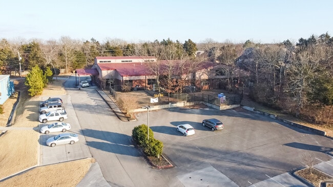
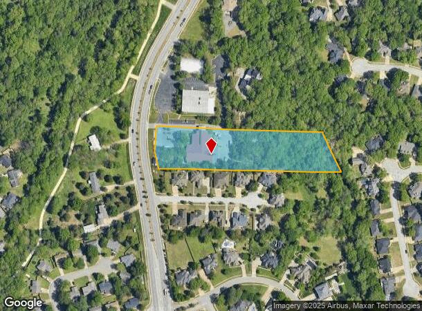
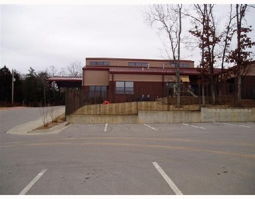
Property Record
2828 N Crossover Rd, Fayetteville, AR 72703
NEARBY LISTINGS FOR SALE OR LEASE
Property Detail
2828 N Crossover Rd
Fayetteville-Springdale-Rogers, AR-MO
Fayetteville Outlots
765-13261-000
PT NW 3.43 AC FURTHER DESCRIBED FROM 2021-21306 AS: PART OF THE SW OF THE NW OF SECTION 31, TOWNSHIP 17 NORTH, RANGE 29 WEST,
Publicschool
Washington
AE
Arkansas
05143C0230G
12
2025
3.43 AC
2025
Greater Fayetteville
010108
Fayetteville/Springdale/Rogers
15,439 SF
DEMOGRAPHICS near 2828 N Crossover Rd
1 Mile
3 Mile
5 Mile
2024 Total Population
6,487
37,866
113,273
2029 Population
7,131
41,242
123,721
Pop Growth 2024-2029
+ 9.93%
+ 8.92%
+ 9.22%
Average Age
39
39
35
2024 Total Households
2,580
16,772
44,706
HH Growth 2024-2029
+ 10.23%
+ 9.15%
+ 9.85%
Median Household Inc
$92,499
$72,444
$61,316
Avg Household Size
2.50
2.20
2.30
2024 Avg HH Vehicles
2.00
2.00
2.00
Median Home Value
$295,822
$316,986
$274,550
Median Year Built
1990
1991
1994
Nearby Places
Map Layers
Map Styles
 Street
 Aerial
- Restaurants
- Banks
- Shops
- Fitness
- Groceries
PUBLIC TRANSPORTATION
AIRPORT
Northwest Arkansas Ntl
DRIVE
WALK
Distance
Northwest Arkansas Ntl
43 min
21.8 mi
Freight Ports
Tulsa Port of Inola
DRIVE
WALK
Distance
Tulsa Port of Inola
111 min
93.2 mi
SALE & LEASE HISTORY
LISTING DATE
SALE/LEASE

Jun 02, 2020
For Sale
Jan 13, 2021
For Lease
Jan 13, 2021
For Sale
Nearby Properties
Address
Land Use
TOTAL SIZE
Lot Size
Zoning
Address
Land Use
TOTAL SIZE
Lot Size
Zoning
153,698 SF
14.10 AC
C2
Address
Land Use
TOTAL SIZE
Lot Size
Zoning
23,707 SF
15.45 AC
R2
Address
Land Use
TOTAL SIZE
Lot Size
Zoning
238,168 SF
Address
Land Use
TOTAL SIZE
Lot Size
Zoning
50,708 SF
1.69 AC
C2
Address
Land Use
TOTAL SIZE
Lot Size
Zoning
232,212 SF
10.31 AC
Address
Land Use
TOTAL SIZE
Lot Size
Zoning
305,272 SF
9.66 AC
R2
Address
Land Use
TOTAL SIZE
Lot Size
Zoning
567,022 SF
88.88 AC
C2
Address
Land Use
TOTAL SIZE
Lot Size
Zoning
6,798 SF
10.56 AC
Address
Land Use
TOTAL SIZE
Lot Size
Zoning
41,952 SF
19.26 AC
Address
Land Use
TOTAL SIZE
Lot Size
Zoning
19,805 SF
0.35 AC
R0
Address
Land Use
TOTAL SIZE
Lot Size
Zoning
178,014 SF
6.43 AC
Address
Land Use
TOTAL SIZE
Lot Size
Zoning
261,670 SF
16.72 AC
R2
Address
Land Use
TOTAL SIZE
Lot Size
Zoning
217,873 SF
24.10 AC
C2
Address
Land Use
TOTAL SIZE
Lot Size
Zoning
56,672 SF
0.53 AC
R0
Address
Land Use
TOTAL SIZE
Lot Size
Zoning
64,659 SF
4.99 AC
R0
Address
Land Use
TOTAL SIZE
Lot Size
Zoning
71,336 SF
6.24 AC
Address
Land Use
TOTAL SIZE
Lot Size
Zoning
20,646 SF
2.45 AC
C2
Address
Land Use
TOTAL SIZE
Lot Size
Zoning
206,047 SF
26.94 AC
R1
Address
Land Use
TOTAL SIZE
Lot Size
Zoning
66,120 SF
1.95 AC
Address
Land Use
TOTAL SIZE
Lot Size
Zoning
12,690 SF
1.72 AC
Address
Land Use
TOTAL SIZE
Lot Size
Zoning
174,848 SF
27.32 AC
R1
Address
Land Use
TOTAL SIZE
Lot Size
Zoning
72,162 SF
3.31 AC
Address
Land Use
TOTAL SIZE
Lot Size
Zoning
96,710 SF
Address
Land Use
TOTAL SIZE
Lot Size
Zoning
55,877 SF
6.43 AC
C2
Address
Land Use
TOTAL SIZE
Lot Size
Zoning
61,431 SF
1.62 AC
C2
Address
Land Use
TOTAL SIZE
Lot Size
Zoning
69,412 SF
8.81 AC
R0
Address
Land Use
TOTAL SIZE
Lot Size
Zoning
63,688 SF
8.24 AC
Address
Land Use
TOTAL SIZE
Lot Size
Zoning
63,197 SF
2.50 AC
R0
Address
Land Use
TOTAL SIZE
Lot Size
Zoning
75,866 SF
5.86 AC
C2
Address
Land Use
TOTAL SIZE
Lot Size
Zoning
217,682 SF
8.28 AC
The World's #1 Commercial Real Estate Marketplace
Connect with us
© 2026 CoStar Group
The information above has been obtained from sources believed reliable. While we do not doubt its accuracy we have not verified it and make no guarantee, warranty or representation about it. It is your responsibility to independently confirm its accuracy and completeness. Any projections, opinions, assumptions, or estimates used are for example only and do not represent the current or future performance of the property. The value of this transaction to you depends on tax and other factors which should be evaluated by your tax, financial, and legal advisors. You and your advisors should conduct a careful, independent investigation of the property to determine to your satisfaction the suitability of the property for your needs.