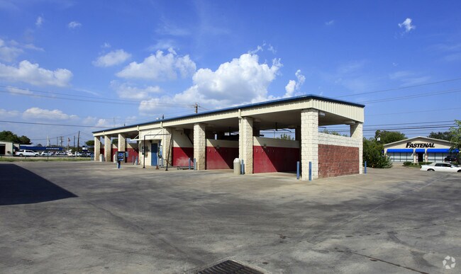
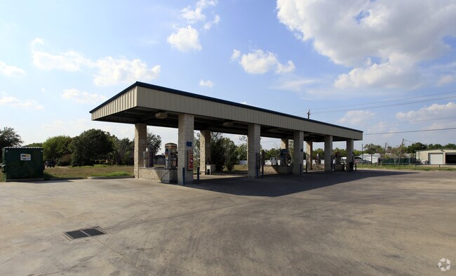
Property Record
2829 N Main St, Baytown, TX 77521

Property Detail
2829 N Main St
Houston-Pasadena-The Woodlands, TX
LT 3 BLK 1 NORTH MAIN CARWASH R/P
1223090010001
HARRIS
Outdoorrecreationbeachmountaindesert
Texas
B and X Area of moderate flood hazard, usually the area between the limits of the 100-year and 500-year floods.
3
2024
1.81 AC
2025
Channelview
253700
Houston
11,468 SF
NEARBY LISTINGS FOR SALE OR LEASE
DEMOGRAPHICS near 2829 N Main St
1 mile
3 mile
5 mile
2025 Total Population
16,703
73,335
108,972
2030 Population
17,990
78,756
117,665
Pop Growth 2025-2030
+ 7.71%
+ 7.39%
+ 7.98%
Average Age
35
36
36
2025 Total Households
5,906
26,272
37,856
HH Growth 2025-2030
+ 7.97%
+ 7.54%
+ 8.12%
Median Household Inc
$53,815
$59,586
$66,006
Avg Household Size
2.70
2.70
2.80
2025 Avg HH Vehicles
2.00
2.00
2.00
Median Home Value
$215,681
$205,631
$226,334
Median Year Built
1981
1981
1986
Nearby Places
Map Layers
Map Styles
 Street
 Aerial
Transit
 Traffic
 Biking
Places
Listings with unknown addresses are not visible on the map
- Restaurants
- Banks
- Shops
- Fitness
- Groceries
PUBLIC TRANSPORTATION
AIRPORT
William P Hobby
Drive
Walk
Distance
William P Hobby
43 min
28.6 mi
George Bush Intcntl/Houston
Drive
Walk
Distance
George Bush Intcntl/Houston
44 min
35.7 mi
Freight Ports
Port of Houston
Drive
Walk
Distance
Port of Houston
34 min
23.6 mi
Nearby Properties
Address
Land Use
TOTAL SIZE
Lot Size
Zoning
Address
Land Use
TOTAL SIZE
Lot Size
Zoning
1,019.77 AC
Address
Land Use
TOTAL SIZE
Lot Size
Zoning
1,019 AC
Address
Land Use
TOTAL SIZE
Lot Size
Zoning
383,631 SF
22.45 AC
Address
Land Use
TOTAL SIZE
Lot Size
Zoning
323,413 SF
26.41 AC
Address
Land Use
TOTAL SIZE
Lot Size
Zoning
284,794 SF
10.18 AC
Address
Land Use
TOTAL SIZE
Lot Size
Zoning
251,498 SF
16.36 AC
Address
Land Use
TOTAL SIZE
Lot Size
Zoning
209,703 SF
11.18 AC
Address
Land Use
TOTAL SIZE
Lot Size
Zoning
225,497 SF
10.90 AC
Address
Land Use
TOTAL SIZE
Lot Size
Zoning
313,810 SF
20 AC
Address
Land Use
TOTAL SIZE
Lot Size
Zoning
238,488 SF
13 AC
Address
Land Use
TOTAL SIZE
Lot Size
Zoning
122,554 SF
12.85 AC
Address
Land Use
TOTAL SIZE
Lot Size
Zoning
205,859 SF
10.88 AC
Address
Land Use
TOTAL SIZE
Lot Size
Zoning
214,627 SF
13.77 AC
Address
Land Use
TOTAL SIZE
Lot Size
Zoning
247,218 SF
12.44 AC
Address
Land Use
TOTAL SIZE
Lot Size
Zoning
313,504 SF
18.76 AC
Address
Land Use
TOTAL SIZE
Lot Size
Zoning
282,661 SF
14.68 AC
Address
Land Use
TOTAL SIZE
Lot Size
Zoning
270,282 SF
15.19 AC
Address
Land Use
TOTAL SIZE
Lot Size
Zoning
7.79 AC
Address
Land Use
TOTAL SIZE
Lot Size
Zoning
221,571 SF
21.28 AC
Address
Land Use
TOTAL SIZE
Lot Size
Zoning
233,074 SF
19.10 AC
Address
Land Use
TOTAL SIZE
Lot Size
Zoning
69,976 SF
7.37 AC
Address
Land Use
TOTAL SIZE
Lot Size
Zoning
203,740 SF
12 AC
Address
Land Use
TOTAL SIZE
Lot Size
Zoning
43,228 SF
6.88 AC
Address
Land Use
TOTAL SIZE
Lot Size
Zoning
42,934 SF
2.60 AC
Address
Land Use
TOTAL SIZE
Lot Size
Zoning
261,760 SF
12.62 AC
Address
Land Use
TOTAL SIZE
Lot Size
Zoning
201,090 SF
12.93 AC
Address
Land Use
TOTAL SIZE
Lot Size
Zoning
178,630 SF
11 AC
Address
Land Use
TOTAL SIZE
Lot Size
Zoning
96,085 SF
8.70 AC
Address
Land Use
TOTAL SIZE
Lot Size
Zoning
218,622 SF
10.77 AC
Address
Land Use
TOTAL SIZE
Lot Size
Zoning
142,021 SF
8.88 AC
The World's #1 Commercial Real Estate Marketplace
Connect with us
© 2026 CoStar Group
The information above has been obtained from sources believed reliable. While we do not doubt its accuracy we have not verified it and make no guarantee, warranty or representation about it. It is your responsibility to independently confirm its accuracy and completeness. Any projections, opinions, assumptions, or estimates used are for example only and do not represent the current or future performance of the property. The value of this transaction to you depends on tax and other factors which should be evaluated by your tax, financial, and legal advisors. You and your advisors should conduct a careful, independent investigation of the property to determine to your satisfaction the suitability of the property for your needs.