Property Record
28385 Freeman Rd, Katy, TX 77493
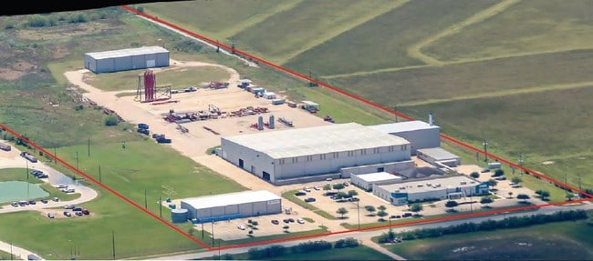

Property Detail
28385 Freeman Rd
164057
ABS A320000 A-200 H & T C R R CO TRACT 2-2 ACRES 15.0 P/O 50.00 ACRES
Industrialgeneral
WALLER
B and X Area of moderate flood hazard, usually the area between the limits of the 100-year and 500-year floods.
Texas
2023
15 AC
2025
Northwest Outliers
542800
Houston
111,361 SF
Houston-Pasadena-The Woodlands, TX
NEARBY LISTINGS FOR SALE OR LEASE
-
-
View all Katy listings for sale on LoopNet.com
DEMOGRAPHICS near 28385 Freeman Rd
1 mile
3 mile
5 mile
2025 Total Population
740
11,286
33,149
2030 Population
903
13,413
38,152
Pop Growth 2025-2030
+ 22.03%
+ 18.85%
+ 15.09%
Average Age
36
35
35
2025 Total Households
241
3,526
10,170
HH Growth 2025-2030
+ 21.99%
+ 19.20%
+ 15.34%
Median Household Inc
$113,749
$118,543
$127,390
Avg Household Size
3.10
3.20
3.20
2025 Avg HH Vehicles
3.00
3.00
2.00
Median Home Value
$503,012
$444,529
$388,635
Median Year Built
2011
2011
2011
Nearby Places
Map Layers
Map Styles
 Street
 Aerial
Layers
 Traffic
 Biking
Places
Listings with unknown addresses are not visible on the map
- Restaurants
- Banks
- Shops
- Fitness
- Groceries
SALE & LEASE HISTORY
LISTING DATE
SALE/LEASE

May 07, 2018
For Sale
Nearby Properties
Address
Land Use
TOTAL SIZE
Lot Size
Zoning
Address
Land Use
TOTAL SIZE
Lot Size
Zoning
117,884 SF
58.56 AC
Address
Land Use
TOTAL SIZE
Lot Size
Zoning
90,000 SF
9.80 AC
Address
Land Use
TOTAL SIZE
Lot Size
Zoning
167,944 SF
12 AC
Address
Land Use
TOTAL SIZE
Lot Size
Zoning
78,032 SF
10.21 AC
Address
Land Use
TOTAL SIZE
Lot Size
Zoning
19,200 SF
101.15 AC
Address
Land Use
TOTAL SIZE
Lot Size
Zoning
54,000 SF
4.49 AC
Address
Land Use
TOTAL SIZE
Lot Size
Zoning
237.62 AC
Address
Land Use
TOTAL SIZE
Lot Size
Zoning
145.57 AC
Address
Land Use
TOTAL SIZE
Lot Size
Zoning
274.70 AC
Address
Land Use
TOTAL SIZE
Lot Size
Zoning
32,307 SF
39.23 AC
Address
Land Use
TOTAL SIZE
Lot Size
Zoning
262.42 AC
Address
Land Use
TOTAL SIZE
Lot Size
Zoning
220.85 AC
Address
Land Use
TOTAL SIZE
Lot Size
Zoning
12,963 SF
23.96 AC
Address
Land Use
TOTAL SIZE
Lot Size
Zoning
83,300 SF
10.06 AC
Address
Land Use
TOTAL SIZE
Lot Size
Zoning
88,860 SF
8.60 AC
Address
Land Use
TOTAL SIZE
Lot Size
Zoning
79.50 AC
Address
Land Use
TOTAL SIZE
Lot Size
Zoning
49,912 SF
10 AC
Address
Land Use
TOTAL SIZE
Lot Size
Zoning
34.82 AC
Address
Land Use
TOTAL SIZE
Lot Size
Zoning
147.42 AC
Address
Land Use
TOTAL SIZE
Lot Size
Zoning
76.83 AC
Address
Land Use
TOTAL SIZE
Lot Size
Zoning
9,000 SF
35 AC
Address
Land Use
TOTAL SIZE
Lot Size
Zoning
47,281 SF
11.66 AC
Address
Land Use
TOTAL SIZE
Lot Size
Zoning
119.10 AC
Address
Land Use
TOTAL SIZE
Lot Size
Zoning
373.27 AC
Address
Land Use
TOTAL SIZE
Lot Size
Zoning
36,000 SF
2.50 AC
Address
Land Use
TOTAL SIZE
Lot Size
Zoning
32,229 SF
5.66 AC
Address
Land Use
TOTAL SIZE
Lot Size
Zoning
53.97 AC
Address
Land Use
TOTAL SIZE
Lot Size
Zoning
15,476 SF
16.84 AC
Address
Land Use
TOTAL SIZE
Lot Size
Zoning
1,364 SF
19 AC
The World's #1 Commercial Real Estate Marketplace
Connect with us
© 2026 CoStar Group
The information above has been obtained from sources believed reliable. While we do not doubt its accuracy we have not verified it and make no guarantee, warranty or representation about it. It is your responsibility to independently confirm its accuracy and completeness. Any projections, opinions, assumptions, or estimates used are for example only and do not represent the current or future performance of the property. The value of this transaction to you depends on tax and other factors which should be evaluated by your tax, financial, and legal advisors. You and your advisors should conduct a careful, independent investigation of the property to determine to your satisfaction the suitability of the property for your needs.