Property Record
2881 S 31St Ave, Greeley, CO 80631

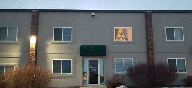
Property Detail
2881 S 31St Ave
Greeley, CO
GR 1OPCC UNIT 18 BLDG D OAKRIDGE PLAZA COMMERCIAL CONDO OF GREELEY 1ST SUPP
R1011002
Weld
Commercialcondominium
Colorado
B and X Area of moderate flood hazard, usually the area between the limits of the 100-year and 500-year floods.
18
2024
0.80 AC
2025
Weld County
001005
Denver
828 SF
NEARBY LISTINGS FOR SALE OR LEASE
DEMOGRAPHICS near 2881 S 31St Ave
1 mile
3 mile
5 mile
2024 Total Population
16,032
108,894
154,633
2029 Population
17,603
120,200
170,448
Pop Growth 2024-2029
+ 9.80%
+ 10.38%
+ 10.23%
Average Age
35
36
36
2024 Total Households
6,192
40,018
55,198
HH Growth 2024-2029
+ 10.26%
+ 11.02%
+ 10.85%
Median Household Inc
$62,193
$64,521
$67,796
Avg Household Size
2.60
2.60
2.70
2024 Avg HH Vehicles
2.00
2.00
2.00
Median Home Value
$367,141
$370,242
$379,742
Median Year Built
1996
1987
1991
Nearby Places
Map Layers
Map Styles
 Street
 Aerial
Transit
 Traffic
 Biking
Places
Listings with unknown addresses are not visible on the map
- Restaurants
- Banks
- Shops
- Fitness
- Groceries
SALE & LEASE HISTORY
LISTING DATE
SALE/LEASE

Sep 24, 2016
For Lease
Oct 25, 2016
For Lease
Oct 14, 2021
For Sale
May 11, 2020
For Lease
Mar 06, 2020
For Lease
Jan 31, 2022
For Lease
Jan 11, 2021
For Sale
Jan 11, 2021
For Sale
Aug 05, 2017
For Sale
Nearby Properties
Address
Land Use
TOTAL SIZE
Lot Size
Zoning
Address
Land Use
TOTAL SIZE
Lot Size
Zoning
1,682,342 SF
134.62 AC
Address
Land Use
TOTAL SIZE
Lot Size
Zoning
1,181,203 SF
23.26 AC
Address
Land Use
TOTAL SIZE
Lot Size
Zoning
669,727 SF
180.71 AC
Address
Land Use
TOTAL SIZE
Lot Size
Zoning
280,000 SF
43.91 AC
Address
Land Use
TOTAL SIZE
Lot Size
Zoning
536,281 SF
33.91 AC
Address
Land Use
TOTAL SIZE
Lot Size
Zoning
237,575 SF
10.77 AC
Address
Land Use
TOTAL SIZE
Lot Size
Zoning
151,418 SF
16.96 AC
Address
Land Use
TOTAL SIZE
Lot Size
Zoning
113,715 SF
9.42 AC
Address
Land Use
TOTAL SIZE
Lot Size
Zoning
78.18 AC
Address
Land Use
TOTAL SIZE
Lot Size
Zoning
83,032 SF
9.23 AC
Address
Land Use
TOTAL SIZE
Lot Size
Zoning
150,693 SF
20 AC
Address
Land Use
TOTAL SIZE
Lot Size
Zoning
118,663 SF
13.36 AC
Address
Land Use
TOTAL SIZE
Lot Size
Zoning
138,446 SF
14.40 AC
Address
Land Use
TOTAL SIZE
Lot Size
Zoning
219,178 SF
22.28 AC
Address
Land Use
TOTAL SIZE
Lot Size
Zoning
214,594 SF
22.70 AC
Address
Land Use
TOTAL SIZE
Lot Size
Zoning
289,203 SF
12.28 AC
Address
Land Use
TOTAL SIZE
Lot Size
Zoning
309,821 SF
13.55 AC
Address
Land Use
TOTAL SIZE
Lot Size
Zoning
122,023 SF
12.29 AC
Address
Land Use
TOTAL SIZE
Lot Size
Zoning
202,130 SF
25.35 AC
Address
Land Use
TOTAL SIZE
Lot Size
Zoning
405,388 SF
17.36 AC
Address
Land Use
TOTAL SIZE
Lot Size
Zoning
239,925 SF
6.06 AC
Address
Land Use
TOTAL SIZE
Lot Size
Zoning
82,759 SF
2.05 AC
Address
Land Use
TOTAL SIZE
Lot Size
Zoning
48,544 SF
7.92 AC
Address
Land Use
TOTAL SIZE
Lot Size
Zoning
198,845 SF
16.02 AC
Address
Land Use
TOTAL SIZE
Lot Size
Zoning
88,620 SF
5.11 AC
Address
Land Use
TOTAL SIZE
Lot Size
Zoning
45,141 SF
12.15 AC
Address
Land Use
TOTAL SIZE
Lot Size
Zoning
240,821 SF
14.53 AC
Address
Land Use
TOTAL SIZE
Lot Size
Zoning
58,754 SF
5.77 AC
Address
Land Use
TOTAL SIZE
Lot Size
Zoning
75,376 SF
11.70 AC
Address
Land Use
TOTAL SIZE
Lot Size
Zoning
114,879 SF
27.73 AC
The World's #1 Commercial Real Estate Marketplace
Connect with us
© 2026 CoStar Group
The information above has been obtained from sources believed reliable. While we do not doubt its accuracy we have not verified it and make no guarantee, warranty or representation about it. It is your responsibility to independently confirm its accuracy and completeness. Any projections, opinions, assumptions, or estimates used are for example only and do not represent the current or future performance of the property. The value of this transaction to you depends on tax and other factors which should be evaluated by your tax, financial, and legal advisors. You and your advisors should conduct a careful, independent investigation of the property to determine to your satisfaction the suitability of the property for your needs.