Property Record
2884 Emanuel Church Rd, West Columbia, SC 29170


NEARBY LISTINGS FOR SALE OR LEASE
-
-
View all West Columbia listings for sale on LoopNet.com
Property Detail
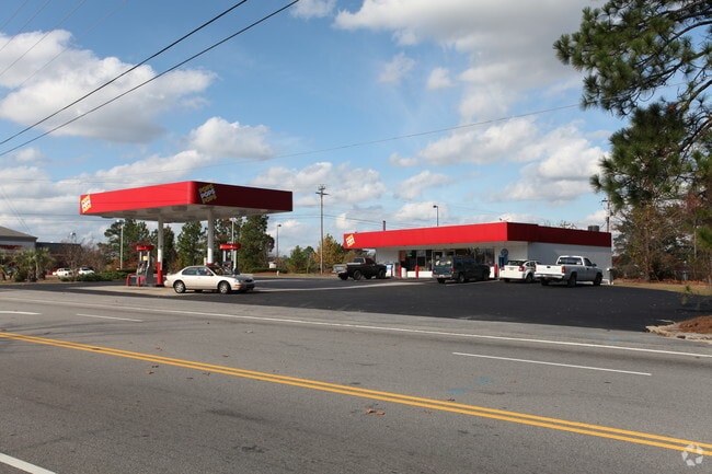
2884 Emanuel Church Rd
005518-01-010
CEDAR ESTATES LOT 23
Conveniencestore
Lexington
X
South Carolina
45063C0258J
23
2025
0.88 AC
2024
Cayce/West Columbia
021034
Columbia
1,924 SF
Columbia, SC
DEMOGRAPHICS near 2884 Emanuel Church Rd
1 Mile
3 Mile
5 Mile
2024 Total Population
5,529
27,779
78,402
2029 Population
5,974
30,169
85,509
Pop Growth 2024-2029
+ 8.05%
+ 8.60%
+ 9.06%
Average Age
39
40
40
2024 Total Households
2,191
11,073
31,612
HH Growth 2024-2029
+ 8.26%
+ 8.77%
+ 9.24%
Median Household Inc
$70,774
$67,247
$64,751
Avg Household Size
2.50
2.50
2.40
2024 Avg HH Vehicles
2.00
2.00
2.00
Median Home Value
$155,335
$155,930
$167,580
Median Year Built
1993
1991
1992
Nearby Places
Map Layers
Map Styles
 Street
 Aerial
- Restaurants
- Banks
- Shops
- Fitness
- Groceries
PUBLIC TRANSPORTATION
COMMUTER RAIL
DRIVE
WALK
Distance
17 min
9.5 mi
AIRPORT
Columbia Metro
DRIVE
WALK
Distance
Columbia Metro
16 min
4.0 mi
SALE & LEASE HISTORY
LISTING DATE
SALE/LEASE

Jan 12, 2022
For Sale
Nearby Properties
Address
Land Use
TOTAL SIZE
Lot Size
Zoning
Address
Land Use
TOTAL SIZE
Lot Size
Zoning
461,888 SF
61.50 AC
ID
Address
Land Use
TOTAL SIZE
Lot Size
Zoning
37,794 SF
22.37 AC
ID
Address
Land Use
TOTAL SIZE
Lot Size
Zoning
58.81 AC
RD
Address
Land Use
TOTAL SIZE
Lot Size
Zoning
257,688 SF
23.03 AC
ID
Address
Land Use
TOTAL SIZE
Lot Size
Zoning
41,860 SF
6.54 AC
ID
Address
Land Use
TOTAL SIZE
Lot Size
Zoning
318,309 SF
33.51 AC
ID
Address
Land Use
TOTAL SIZE
Lot Size
Zoning
70,740 SF
13 AC
ID
Address
Land Use
TOTAL SIZE
Lot Size
Zoning
59.61 AC
ID
Address
Land Use
TOTAL SIZE
Lot Size
Zoning
430.11 AC
ID
Address
Land Use
TOTAL SIZE
Lot Size
Zoning
8,269 SF
12.99 AC
RD
Address
Land Use
TOTAL SIZE
Lot Size
Zoning
10.52 AC
ID
Address
Land Use
TOTAL SIZE
Lot Size
Zoning
115,000 SF
11.99 AC
ID
Address
Land Use
TOTAL SIZE
Lot Size
Zoning
73,778 SF
4.95 AC
A
Address
Land Use
TOTAL SIZE
Lot Size
Zoning
17,442 SF
2.78 AC
Address
Land Use
TOTAL SIZE
Lot Size
Zoning
54,092 SF
5.90 AC
ID
Address
Land Use
TOTAL SIZE
Lot Size
Zoning
95,730 SF
8.15 AC
ID
Address
Land Use
TOTAL SIZE
Lot Size
Zoning
52,096 SF
10.35 AC
ID
Address
Land Use
TOTAL SIZE
Lot Size
Zoning
11,425 SF
5.67 AC
ID
Address
Land Use
TOTAL SIZE
Lot Size
Zoning
47,126 SF
4.53 AC
Address
Land Use
TOTAL SIZE
Lot Size
Zoning
10,286 SF
1.75 AC
ID
Address
Land Use
TOTAL SIZE
Lot Size
Zoning
42,842 SF
6.47 AC
ID
Address
Land Use
TOTAL SIZE
Lot Size
Zoning
96,736 SF
8.30 AC
Address
Land Use
TOTAL SIZE
Lot Size
Zoning
78.48 AC
ID
Address
Land Use
TOTAL SIZE
Lot Size
Zoning
10.48 AC
RD
Address
Land Use
TOTAL SIZE
Lot Size
Zoning
31,000 SF
7.49 AC
C2
Address
Land Use
TOTAL SIZE
Lot Size
Zoning
218.28 AC
RD
Address
Land Use
TOTAL SIZE
Lot Size
Zoning
21,261 SF
9.84 AC
ID
Address
Land Use
TOTAL SIZE
Lot Size
Zoning
6.44 AC
ID
Address
Land Use
TOTAL SIZE
Lot Size
Zoning
23,601 SF
6.98 AC
ID
Address
Land Use
TOTAL SIZE
Lot Size
Zoning
32,239 SF
2.66 AC
ID
The World's #1 Commercial Real Estate Marketplace
Connect with us
© 2026 CoStar Group
The information above has been obtained from sources believed reliable. While we do not doubt its accuracy we have not verified it and make no guarantee, warranty or representation about it. It is your responsibility to independently confirm its accuracy and completeness. Any projections, opinions, assumptions, or estimates used are for example only and do not represent the current or future performance of the property. The value of this transaction to you depends on tax and other factors which should be evaluated by your tax, financial, and legal advisors. You and your advisors should conduct a careful, independent investigation of the property to determine to your satisfaction the suitability of the property for your needs.