Property Record
2884 S Main St, Niles, OH 44446


Save to a Folder
{{folder.Name}}
{{folder.ListingIds.length}} Properties
{{folder.ListingIds.length}} Property
Create a New Folder
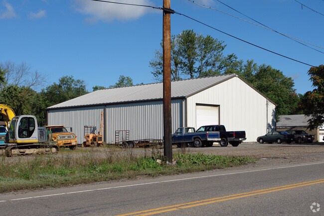
Property Detail
2884 S Main St
Youngstown-Warren, OH
10& 5 9.654 11 16000 PT S MAIN ST EXTN NILES CITY
25-486950
Trumbull
Publicstorage
Ohio
AE The base floodplain where base flood elevations are provided. AE Zones are now used on new format FIRMs instead of A1-A30 Zones.
5
2025
9.65 AC
2025
Niles
932802
Youngstown/Warren/Boardman
4,800 SF
NEARBY LISTINGS FOR SALE OR LEASE
DEMOGRAPHICS near 2884 S Main St
1 mile
3 mile
5 mile
2025 Total Population
1,988
29,671
71,062
2030 Population
1,963
29,416
70,638
Pop Growth 2025-2030
(1.26%)
(0.86%)
(0.60%)
Average Age
42
43
43
2025 Total Households
845
13,170
31,611
HH Growth 2025-2030
(1.42%)
(0.90%)
(0.66%)
Median Household Inc
$43,026
$49,850
$47,514
Avg Household Size
2.30
2.20
2.20
2025 Avg HH Vehicles
2.00
2.00
2.00
Median Home Value
$76,867
$130,215
$129,534
Median Year Built
1949
1964
1961
Nearby Places
Map Layers
Map Styles
 Street
 Aerial
Layers
 Traffic
 Biking
Places
Listings with unknown addresses are not visible on the map
- Restaurants
- Banks
- Shops
- Fitness
- Groceries
Nearby Properties
Address
Land Use
TOTAL SIZE
Lot Size
Zoning
Address
Land Use
TOTAL SIZE
Lot Size
Zoning
1,582.88 AC
Address
Land Use
TOTAL SIZE
Lot Size
Zoning
8,642 SF
16.50 AC
Address
Land Use
TOTAL SIZE
Lot Size
Zoning
10.30 AC
Address
Land Use
TOTAL SIZE
Lot Size
Zoning
77,500 SF
15.96 AC
Address
Land Use
TOTAL SIZE
Lot Size
Zoning
69,132 SF
10 AC
Address
Land Use
TOTAL SIZE
Lot Size
Zoning
14.92 AC
Address
Land Use
TOTAL SIZE
Lot Size
Zoning
97,754 SF
68.10 AC
Address
Land Use
TOTAL SIZE
Lot Size
Zoning
98,609 SF
11.01 AC
Address
Land Use
TOTAL SIZE
Lot Size
Zoning
13,464 SF
21.34 AC
Address
Land Use
TOTAL SIZE
Lot Size
Zoning
58,282 SF
24.96 AC
Address
Land Use
TOTAL SIZE
Lot Size
Zoning
1,129 SF
100.32 AC
Address
Land Use
TOTAL SIZE
Lot Size
Zoning
71,678 SF
7.78 AC
Address
Land Use
TOTAL SIZE
Lot Size
Zoning
95,231 SF
37.75 AC
ASER
Address
Land Use
TOTAL SIZE
Lot Size
Zoning
5,616 SF
23.43 AC
Address
Land Use
TOTAL SIZE
Lot Size
Zoning
2,080 SF
13.83 AC
Address
Land Use
TOTAL SIZE
Lot Size
Zoning
54,969 SF
6.17 AC
Address
Land Use
TOTAL SIZE
Lot Size
Zoning
66,089 SF
3.01 AC
B2
Address
Land Use
TOTAL SIZE
Lot Size
Zoning
153,848 SF
16.95 AC
Address
Land Use
TOTAL SIZE
Lot Size
Zoning
11,316 SF
8.86 AC
Address
Land Use
TOTAL SIZE
Lot Size
Zoning
28,454 SF
6.18 AC
Address
Land Use
TOTAL SIZE
Lot Size
Zoning
69,160 SF
22.87 AC
Address
Land Use
TOTAL SIZE
Lot Size
Zoning
9,069 SF
15.49 AC
B2
Address
Land Use
TOTAL SIZE
Lot Size
Zoning
98,943 SF
1.48 AC
Address
Land Use
TOTAL SIZE
Lot Size
Zoning
48,638 SF
2.05 AC
B2
Address
Land Use
TOTAL SIZE
Lot Size
Zoning
33,792 SF
10.18 AC
Address
Land Use
TOTAL SIZE
Lot Size
Zoning
49,094 SF
2.40 AC
B2
Address
Land Use
TOTAL SIZE
Lot Size
Zoning
65,800 SF
1.08 AC
Address
Land Use
TOTAL SIZE
Lot Size
Zoning
7,380 SF
5.08 AC
Address
Land Use
TOTAL SIZE
Lot Size
Zoning
59,388 SF
2.95 AC
Address
Land Use
TOTAL SIZE
Lot Size
Zoning
20,628 SF
4.53 AC
The World's #1 Commercial Real Estate Marketplace
Connect with us
© 2026 CoStar Group
The information above has been obtained from sources believed reliable. While we do not doubt its accuracy we have not verified it and make no guarantee, warranty or representation about it. It is your responsibility to independently confirm its accuracy and completeness. Any projections, opinions, assumptions, or estimates used are for example only and do not represent the current or future performance of the property. The value of this transaction to you depends on tax and other factors which should be evaluated by your tax, financial, and legal advisors. You and your advisors should conduct a careful, independent investigation of the property to determine to your satisfaction the suitability of the property for your needs.