Property Record
28850 Jones Loop Rd, Punta Gorda, FL 33982
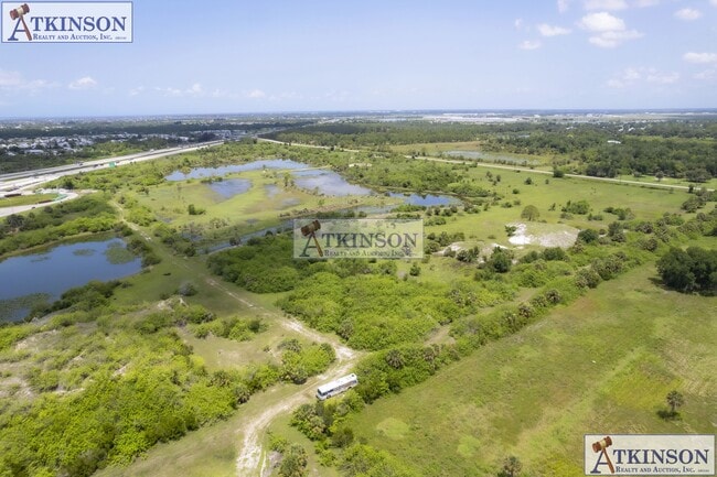


This Property Is For Sale
Property Detail
28850 Jones Loop Rd
412326100005
26 41 23 P-5 143.962A M/LTHAT PORTION OF S1/2 OF NW1/4 AND SW1/4 AND W1/2 OF SE1/4 NE OF I-75 AND PARCEL 5-1 FURTHER LESS ROW SR 768 JONES LOOP RD 396/649 391/801 561/104 566/1908 699/1019 1754/172 2659/1341
Pasture
CHARLOTTE
RMF5
Florida
A Areas with a 1% annual chance of flooding and a 26% chance of flooding over the life of a 30-year mortgage.
143.96 AC
2024
Charlotte County
2025
Southwest Florida
010100
Punta Gorda, FL
NEARBY LISTINGS FOR SALE OR LEASE
DEMOGRAPHICS near 28850 Jones Loop Rd
1 mile
3 mile
5 mile
2025 Total Population
1,105
11,688
26,431
2030 Population
1,228
12,947
29,050
Pop Growth 2025-2030
+ 11.13%
+ 10.77%
+ 9.91%
Average Age
58
53
55
2025 Total Households
531
5,185
12,415
HH Growth 2025-2030
+ 11.30%
+ 10.80%
+ 9.75%
Median Household Inc
$44,124
$82,931
$71,451
Avg Household Size
2.00
2.10
2.10
2025 Avg HH Vehicles
2.00
2.00
2.00
Median Home Value
$148,113
$347,681
$368,249
Median Year Built
2002
2001
1998
Nearby Places
Map Layers
Map Styles
 Street
 Aerial
Layers
 Traffic
 Biking
Places
Listings with unknown addresses are not visible on the map
- Restaurants
- Banks
- Shops
- Fitness
- Groceries
PUBLIC TRANSPORTATION
AIRPORT
Punta Gorda
Drive
Walk
Distance
Punta Gorda
7 min
3.5 mi
Southwest Florida International
Drive
Walk
Distance
Southwest Florida International
43 min
35.0 mi
Freight Ports
Port Manatee
Drive
Walk
Distance
Port Manatee
87 min
75.2 mi
Nearby Properties
Address
Land Use
TOTAL SIZE
Lot Size
Zoning
Address
Land Use
TOTAL SIZE
Lot Size
Zoning
164,121 SF
44.20 AC
ECAP
Address
Land Use
TOTAL SIZE
Lot Size
Zoning
265,949 SF
22.80 AC
PD-CC
Address
Land Use
TOTAL SIZE
Lot Size
Zoning
253,440 SF
30.47 AC
ECAP
Address
Land Use
TOTAL SIZE
Lot Size
Zoning
378,000 SF
29.24 AC
ECAP
Address
Land Use
TOTAL SIZE
Lot Size
Zoning
345,043 SF
33.12 AC
ECAP
Address
Land Use
TOTAL SIZE
Lot Size
Zoning
62,415 SF
281.65 AC
ECAP
Address
Land Use
TOTAL SIZE
Lot Size
Zoning
198,916 SF
25.79 AC
HC
Address
Land Use
TOTAL SIZE
Lot Size
Zoning
96,845 SF
17.62 AC
HC
Address
Land Use
TOTAL SIZE
Lot Size
Zoning
8,406 SF
31.48 AC
ECAP
Address
Land Use
TOTAL SIZE
Lot Size
Zoning
104,398 SF
12.97 AC
HC
Address
Land Use
TOTAL SIZE
Lot Size
Zoning
13,260 SF
2.27 AC
CG
Address
Land Use
TOTAL SIZE
Lot Size
Zoning
65,396 SF
5.13 AC
HC
Address
Land Use
TOTAL SIZE
Lot Size
Zoning
63,770 SF
5 AC
ECAP
Address
Land Use
TOTAL SIZE
Lot Size
Zoning
65,141 SF
9.56 AC
HC
Address
Land Use
TOTAL SIZE
Lot Size
Zoning
15,134 SF
2.03 AC
CG
Address
Land Use
TOTAL SIZE
Lot Size
Zoning
40,000 SF
20 AC
ECAP
Address
Land Use
TOTAL SIZE
Lot Size
Zoning
18.93 AC
HC
Address
Land Use
TOTAL SIZE
Lot Size
Zoning
68,773 SF
8.05 AC
ECAP
Address
Land Use
TOTAL SIZE
Lot Size
Zoning
43,500 SF
9.84 AC
CG
Address
Land Use
TOTAL SIZE
Lot Size
Zoning
17.81 AC
HC
Address
Land Use
TOTAL SIZE
Lot Size
Zoning
21,583 SF
590.79 AC
ES
Address
Land Use
TOTAL SIZE
Lot Size
Zoning
Address
Land Use
TOTAL SIZE
Lot Size
Zoning
12,408 SF
1.92 AC
CG
Address
Land Use
TOTAL SIZE
Lot Size
Zoning
22,597 SF
3.43 AC
HC
Address
Land Use
TOTAL SIZE
Lot Size
Zoning
7,128 SF
0.76 AC
ECAP
Address
Land Use
TOTAL SIZE
Lot Size
Zoning
636 AC
ES
Address
Land Use
TOTAL SIZE
Lot Size
Zoning
636 AC
ES
Address
Land Use
TOTAL SIZE
Lot Size
Zoning
20,271 SF
6.26 AC
CG
Address
Land Use
TOTAL SIZE
Lot Size
Zoning
28,730 SF
11.64 AC
NC
Address
Land Use
TOTAL SIZE
Lot Size
Zoning
The World's #1 Commercial Real Estate Marketplace
Connect with us
© 2026 CoStar Group
The information above has been obtained from sources believed reliable. While we do not doubt its accuracy we have not verified it and make no guarantee, warranty or representation about it. It is your responsibility to independently confirm its accuracy and completeness. Any projections, opinions, assumptions, or estimates used are for example only and do not represent the current or future performance of the property. The value of this transaction to you depends on tax and other factors which should be evaluated by your tax, financial, and legal advisors. You and your advisors should conduct a careful, independent investigation of the property to determine to your satisfaction the suitability of the property for your needs.