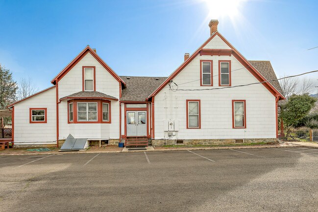
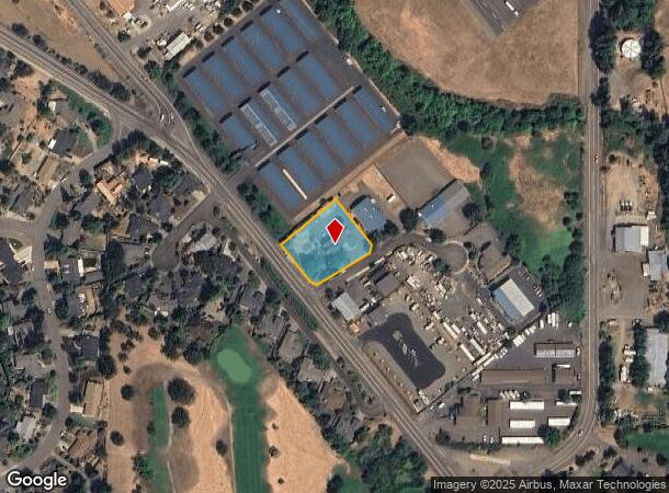
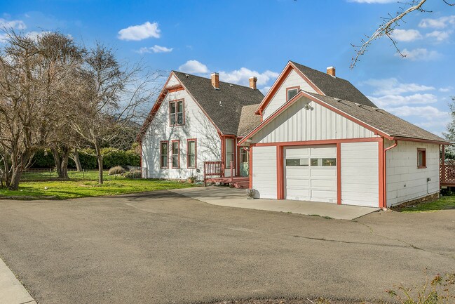
Property Record
2895 Highway 66, Ashland, OR 97520
NEARBY LISTINGS FOR SALE OR LEASE
Property Detail
2895 Highway 66
10116240
Partition Plat # P-14-1998
Charitableorganization
Jackson
X
Oregon
41029C2216G
1
0
0.66 AC
2025
Other Market Areas
002400
Medford, OR
3,642 SF
DEMOGRAPHICS near 2895 Highway 66
1 Mile
3 Mile
5 Mile
2024 Total Population
2,413
20,754
27,351
2029 Population
2,416
21,340
27,979
Pop Growth 2024-2029
+ 0.12%
+ 2.82%
+ 2.30%
Average Age
46
43
44
2024 Total Households
1,131
9,533
12,583
HH Growth 2024-2029
0.00%
+ 3.06%
+ 2.46%
Median Household Inc
$72,430
$59,102
$64,970
Avg Household Size
2.10
2.00
2.00
2024 Avg HH Vehicles
2.00
2.00
2.00
Median Home Value
$439,604
$528,823
$556,869
Median Year Built
1993
1986
1984
Nearby Places
Map Layers
Map Styles
 Street
 Aerial
- Restaurants
- Banks
- Shops
- Fitness
- Groceries
PUBLIC TRANSPORTATION
AIRPORT
Rogue Valley International - Medford
DRIVE
WALK
Distance
Rogue Valley International - Medford
25 min
18.4 mi
Freight Ports
Port of Coos Bay, OR
DRIVE
WALK
Distance
Port of Coos Bay, OR
233 min
179.8 mi
SALE & LEASE HISTORY
LISTING DATE
SALE/LEASE

Jan 16, 2018
For Sale
Nearby Properties
Address
Land Use
TOTAL SIZE
Lot Size
Zoning
Address
Land Use
TOTAL SIZE
Lot Size
Zoning
17.46 AC
SO
Address
Land Use
TOTAL SIZE
Lot Size
Zoning
78,000 SF
15.17 AC
SO
Address
Land Use
TOTAL SIZE
Lot Size
Zoning
25,300 SF
14.69 AC
SO
Address
Land Use
TOTAL SIZE
Lot Size
Zoning
21.36 AC
SO
Address
Land Use
TOTAL SIZE
Lot Size
Zoning
25.14 AC
R-1-5
Address
Land Use
TOTAL SIZE
Lot Size
Zoning
9.73 AC
R-1-5
Address
Land Use
TOTAL SIZE
Lot Size
Zoning
11.04 AC
SO
Address
Land Use
TOTAL SIZE
Lot Size
Zoning
12.05 AC
R-2
Address
Land Use
TOTAL SIZE
Lot Size
Zoning
29.34 AC
SO
Address
Land Use
TOTAL SIZE
Lot Size
Zoning
123,060 SF
7.22 AC
SO
Address
Land Use
TOTAL SIZE
Lot Size
Zoning
3.46 AC
R-2
Address
Land Use
TOTAL SIZE
Lot Size
Zoning
196,614 SF
10.05 AC
C-1
Address
Land Use
TOTAL SIZE
Lot Size
Zoning
43,034 SF
0.96 AC
C-1-D
Address
Land Use
TOTAL SIZE
Lot Size
Zoning
26,208 SF
2.85 AC
HC
Address
Land Use
TOTAL SIZE
Lot Size
Zoning
24.96 AC
WR
Address
Land Use
TOTAL SIZE
Lot Size
Zoning
320,862 SF
5.91 AC
C-1
Address
Land Use
TOTAL SIZE
Lot Size
Zoning
21,098 SF
56.38 AC
EFU
Address
Land Use
TOTAL SIZE
Lot Size
Zoning
20.03 AC
WR-20
Address
Land Use
TOTAL SIZE
Lot Size
Zoning
0.37 AC
C-1-D
Address
Land Use
TOTAL SIZE
Lot Size
Zoning
40,673 SF
2.72 AC
C-1
Address
Land Use
TOTAL SIZE
Lot Size
Zoning
18.84 AC
WR-20
Address
Land Use
TOTAL SIZE
Lot Size
Zoning
56,386 SF
2.98 AC
C-1
Address
Land Use
TOTAL SIZE
Lot Size
Zoning
65,160 SF
4.82 AC
E-1
Address
Land Use
TOTAL SIZE
Lot Size
Zoning
42,033 SF
8.48 AC
E-1
Address
Land Use
TOTAL SIZE
Lot Size
Zoning
104,679 SF
3.59 AC
R-3
Address
Land Use
TOTAL SIZE
Lot Size
Zoning
28,860 SF
1.54 AC
R-2
Address
Land Use
TOTAL SIZE
Lot Size
Zoning
43,456 SF
3.99 AC
C-1
Address
Land Use
TOTAL SIZE
Lot Size
Zoning
45,096 SF
2.57 AC
R-2
Address
Land Use
TOTAL SIZE
Lot Size
Zoning
45,310 SF
1.78 AC
C-1
Address
Land Use
TOTAL SIZE
Lot Size
Zoning
5.53 AC
RR-.5
The World's #1 Commercial Real Estate Marketplace
Connect with us
© 2025 CoStar Group
The information above has been obtained from sources believed reliable. While we do not doubt its accuracy we have not verified it and make no guarantee, warranty or representation about it. It is your responsibility to independently confirm its accuracy and completeness. Any projections, opinions, assumptions, or estimates used are for example only and do not represent the current or future performance of the property. The value of this transaction to you depends on tax and other factors which should be evaluated by your tax, financial, and legal advisors. You and your advisors should conduct a careful, independent investigation of the property to determine to your satisfaction the suitability of the property for your needs.