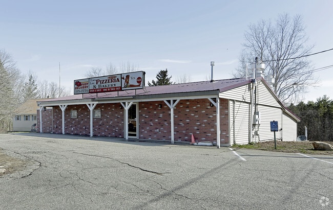
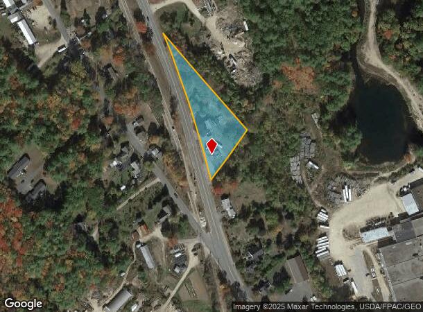
Property Record
287 Milton Rd, Rochester, NH 03868
NEARBY LISTINGS FOR SALE OR LEASE
-
-
View all Rochester listings for sale on LoopNet.com
Property Detail
287 Milton Rd
Commercialnec
Strafford
X
New Hampshire
23031C0363G
1.40 AC
2024
Strafford County
2024
Boston
084201
Boston-Cambridge-Newton, MA-NH
3,015 SF
RCHE-000201-000014
DEMOGRAPHICS near 287 Milton Rd
1 Mile
3 Mile
5 Mile
2024 Total Population
1,321
6,526
28,152
2029 Population
1,376
6,795
29,381
Pop Growth 2024-2029
+ 4.16%
+ 4.12%
+ 4.37%
Average Age
43
43
42
2024 Total Households
538
2,661
11,713
HH Growth 2024-2029
+ 4.28%
+ 4.17%
+ 4.39%
Median Household Inc
$98,181
$100,123
$84,818
Avg Household Size
2.40
2.40
2.40
2024 Avg HH Vehicles
2.00
2.00
2.00
Median Home Value
$235,897
$238,481
$247,122
Median Year Built
1983
1983
1977
Nearby Places
Map Layers
Map Styles
 Street
 Aerial
- Restaurants
- Banks
- Shops
- Fitness
- Groceries
PUBLIC TRANSPORTATION
AIRPORT
Portsmouth International at Pease
DRIVE
WALK
Distance
Portsmouth International at Pease
39 min
25.7 mi
Freight Ports
Portland, ME
DRIVE
WALK
Distance
Portland, ME
73 min
51.4 mi
SALE & LEASE HISTORY
LISTING DATE
SALE/LEASE

Sep 24, 2016
For Sale
Jun 06, 2023
For Sale
Nearby Properties
Address
Land Use
TOTAL SIZE
Lot Size
Zoning
Address
Land Use
TOTAL SIZE
Lot Size
Zoning
123,860 SF
8.75 AC
IND/CO
Address
Land Use
TOTAL SIZE
Lot Size
Zoning
59,235 SF
22.08 AC
A
Address
Land Use
TOTAL SIZE
Lot Size
Zoning
111,807 SF
31.93 AC
HC
Address
Land Use
TOTAL SIZE
Lot Size
Zoning
221,995 SF
35.47 AC
IND
Address
Land Use
TOTAL SIZE
Lot Size
Zoning
61,383 SF
9.60 AC
HIGH D
Address
Land Use
TOTAL SIZE
Lot Size
Zoning
87.64 AC
A
Address
Land Use
TOTAL SIZE
Lot Size
Zoning
30 AC
RA
Address
Land Use
TOTAL SIZE
Lot Size
Zoning
66,994 SF
38.56 AC
IB IND
Address
Land Use
TOTAL SIZE
Lot Size
Zoning
1,288 SF
72 AC
A
Address
Land Use
TOTAL SIZE
Lot Size
Zoning
5,048 SF
165.49 AC
A
Address
Land Use
TOTAL SIZE
Lot Size
Zoning
35,049 SF
4.61 AC
HIGH D
Address
Land Use
TOTAL SIZE
Lot Size
Zoning
10,172 SF
92.55 AC
A
Address
Land Use
TOTAL SIZE
Lot Size
Zoning
39 AC
A
Address
Land Use
TOTAL SIZE
Lot Size
Zoning
1,800 SF
5.50 AC
CIBO C
Address
Land Use
TOTAL SIZE
Lot Size
Zoning
24,000 SF
6.67 AC
GRD
Address
Land Use
TOTAL SIZE
Lot Size
Zoning
3,472 SF
4.65 AC
CB COM
Address
Land Use
TOTAL SIZE
Lot Size
Zoning
6,000 SF
2.30 AC
IND/CO
Address
Land Use
TOTAL SIZE
Lot Size
Zoning
4,756 SF
1.27 AC
HC
Address
Land Use
TOTAL SIZE
Lot Size
Zoning
18,875 SF
5.44 AC
GRD
Address
Land Use
TOTAL SIZE
Lot Size
Zoning
2,583 SF
1.30 AC
LOW DE
Address
Land Use
TOTAL SIZE
Lot Size
Zoning
10,332 SF
2.88 AC
GRD
Address
Land Use
TOTAL SIZE
Lot Size
Zoning
516 SF
23.09 AC
IND
Address
Land Use
TOTAL SIZE
Lot Size
Zoning
10,750 SF
2 AC
IND/CO
Address
Land Use
TOTAL SIZE
Lot Size
Zoning
192,505 SF
25.50 AC
IND
Address
Land Use
TOTAL SIZE
Lot Size
Zoning
5,106 SF
3.65 AC
IND/CO
Address
Land Use
TOTAL SIZE
Lot Size
Zoning
4,032 SF
1.65 AC
CB COM
Address
Land Use
TOTAL SIZE
Lot Size
Zoning
3,703 SF
15.60 AC
A
Address
Land Use
TOTAL SIZE
Lot Size
Zoning
14,895 SF
5.92 AC
IND/CO
Address
Land Use
TOTAL SIZE
Lot Size
Zoning
8,108 SF
3.18 AC
IND/CO
Address
Land Use
TOTAL SIZE
Lot Size
Zoning
2,954 SF
1.93 AC
GRD
The World's #1 Commercial Real Estate Marketplace
Connect with us
© 2025 CoStar Group
The information above has been obtained from sources believed reliable. While we do not doubt its accuracy we have not verified it and make no guarantee, warranty or representation about it. It is your responsibility to independently confirm its accuracy and completeness. Any projections, opinions, assumptions, or estimates used are for example only and do not represent the current or future performance of the property. The value of this transaction to you depends on tax and other factors which should be evaluated by your tax, financial, and legal advisors. You and your advisors should conduct a careful, independent investigation of the property to determine to your satisfaction the suitability of the property for your needs.