Property Record
2900 W 44Th Ave, Denver, CO 80211
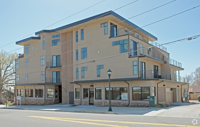
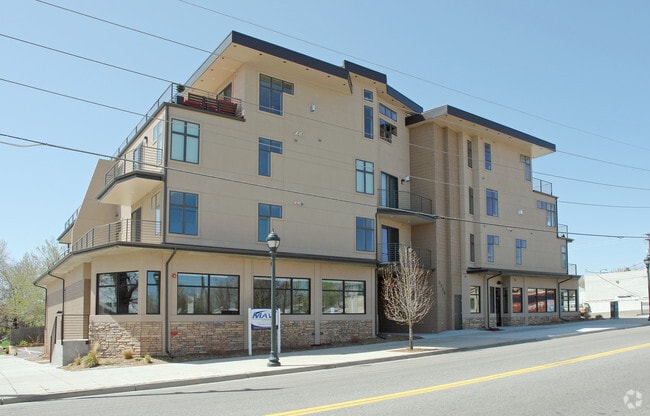
This Property Is For Sale
Current Lease Availabilities
NEARBY LISTINGS FOR SALE OR LEASE
Property Detail
2900 W 44Th Ave
2204-06-053
Terraces At Siena Condos U-402
Condominium
TERRACES AT SIENA CONDOS U-102 PRK-7 STR-2
X
Denver
0800460069J
Colorado
2024
0.03 AC
2024
Sunnyside
000401
Denver
967 SF
Denver-Aurora-Lakewood, CO
DEMOGRAPHICS near 2900 W 44Th Ave
1 Mile
3 Mile
5 Mile
2024 Total Population
21,794
164,486
442,101
2029 Population
21,897
168,125
448,504
Pop Growth 2024-2029
+ 0.47%
+ 2.21%
+ 1.45%
Average Age
38
37
38
2024 Total Households
9,572
80,399
206,184
HH Growth 2024-2029
+ 0.39%
+ 2.30%
+ 1.49%
Median Household Inc
$105,112
$91,457
$76,913
Avg Household Size
2.20
1.90
2.00
2024 Avg HH Vehicles
2.00
1.00
2.00
Median Home Value
$670,324
$646,333
$520,676
Median Year Built
1948
1983
1968
Nearby Places
Map Layers
Map Styles
 Street
 Aerial
- Restaurants
- Banks
- Shops
- Fitness
- Groceries
PUBLIC TRANSPORTATION
COMMUTER RAIL
41St & Fox Station Track 1 (Union Station to Westminster Station - Regional Transportation District, Union Station to Wheat Ridge Ward Station - Regional Transportation District)
DRIVE
WALK
Distance
41St & Fox Station Track 1 (Union Station to Westminster Station - Regional Transportation District, Union Station to Wheat Ridge Ward Station - Regional Transportation District)
7 min
2.6 mi
41St & Fox Station Track 2 (Union Station to Westminster Station - Regional Transportation District, Union Station to Wheat Ridge Ward Station - Regional Transportation District)
DRIVE
WALK
Distance
41St & Fox Station Track 2 (Union Station to Westminster Station - Regional Transportation District, Union Station to Wheat Ridge Ward Station - Regional Transportation District)
7 min
2.6 mi
AIRPORT
Denver International
DRIVE
WALK
Distance
Denver International
31 min
24.7 mi
Freight Ports
Tulsa Port Of Catoosa
DRIVE
WALK
Distance
Tulsa Port Of Catoosa
728 min
710.2 mi
Nearby Properties
Address
Land Use
TOTAL SIZE
Lot Size
Zoning
Address
Land Use
TOTAL SIZE
Lot Size
Zoning
1,882,179 SF
21.15 AC
D-TD
Address
Land Use
TOTAL SIZE
Lot Size
Zoning
1,721,086 SF
21.34 AC
C-MU-30
Address
Land Use
TOTAL SIZE
Lot Size
Zoning
794,383 SF
0.90 AC
D-TD
Address
Land Use
TOTAL SIZE
Lot Size
Zoning
1,542,612 SF
1.56 AC
D-C
Address
Land Use
TOTAL SIZE
Lot Size
Zoning
1,567,575 SF
1.40 AC
D-C
Address
Land Use
TOTAL SIZE
Lot Size
Zoning
1,048,471 SF
2.44 AC
PUD
Address
Land Use
TOTAL SIZE
Lot Size
Zoning
545,292 SF
1.15 AC
D-C
Address
Land Use
TOTAL SIZE
Lot Size
Zoning
614,750 SF
0.23 AC
D-C
Address
Land Use
TOTAL SIZE
Lot Size
Zoning
611,828 SF
0.94 AC
PUD
Address
Land Use
TOTAL SIZE
Lot Size
Zoning
150,202 SF
13.24 AC
T-MU-30
Address
Land Use
TOTAL SIZE
Lot Size
Zoning
337,495 SF
0.57 AC
D-C
Address
Land Use
TOTAL SIZE
Lot Size
Zoning
858,528 SF
2.53 AC
D-C
Address
Land Use
TOTAL SIZE
Lot Size
Zoning
755,793 SF
2.44 AC
D-C
Address
Land Use
TOTAL SIZE
Lot Size
Zoning
298,387 SF
0.88 AC
PUD
Address
Land Use
TOTAL SIZE
Lot Size
Zoning
724,981 SF
1.26 AC
D-C
Address
Land Use
TOTAL SIZE
Lot Size
Zoning
405,974 SF
1.78 AC
PUD
Address
Land Use
TOTAL SIZE
Lot Size
Zoning
1,018,386 SF
2.46 AC
D-C
Address
Land Use
TOTAL SIZE
Lot Size
Zoning
290,821 SF
1.16 AC
PUD
Address
Land Use
TOTAL SIZE
Lot Size
Zoning
604,358 SF
2.45 AC
D-C
Address
Land Use
TOTAL SIZE
Lot Size
Zoning
716,151 SF
2.45 AC
D-C
Address
Land Use
TOTAL SIZE
Lot Size
Zoning
618,768 SF
1.23 AC
D-C
Address
Land Use
TOTAL SIZE
Lot Size
Zoning
778,340 SF
0.61 AC
D-C
Address
Land Use
TOTAL SIZE
Lot Size
Zoning
334,746 SF
1.25 AC
D-LD
Address
Land Use
TOTAL SIZE
Lot Size
Zoning
764,724 SF
1 AC
D-C
Address
Land Use
TOTAL SIZE
Lot Size
Zoning
1,078,109 SF
36.79 AC
CMP-EI
Address
Land Use
TOTAL SIZE
Lot Size
Zoning
888,385 SF
20.40 AC
I-A
Address
Land Use
TOTAL SIZE
Lot Size
Zoning
343,483 SF
5.62 AC
D-TD
Address
Land Use
TOTAL SIZE
Lot Size
Zoning
345,616 SF
3.45 AC
PUD
Address
Land Use
TOTAL SIZE
Lot Size
Zoning
860,132 SF
68.50 AC
R-5
Address
Land Use
TOTAL SIZE
Lot Size
Zoning
424,862 SF
32.28 AC
G-MU-3
The World's #1 Commercial Real Estate Marketplace
Connect with us
© 2025 CoStar Group
The information above has been obtained from sources believed reliable. While we do not doubt its accuracy we have not verified it and make no guarantee, warranty or representation about it. It is your responsibility to independently confirm its accuracy and completeness. Any projections, opinions, assumptions, or estimates used are for example only and do not represent the current or future performance of the property. The value of this transaction to you depends on tax and other factors which should be evaluated by your tax, financial, and legal advisors. You and your advisors should conduct a careful, independent investigation of the property to determine to your satisfaction the suitability of the property for your needs.