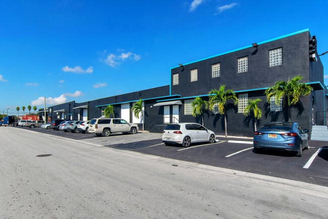
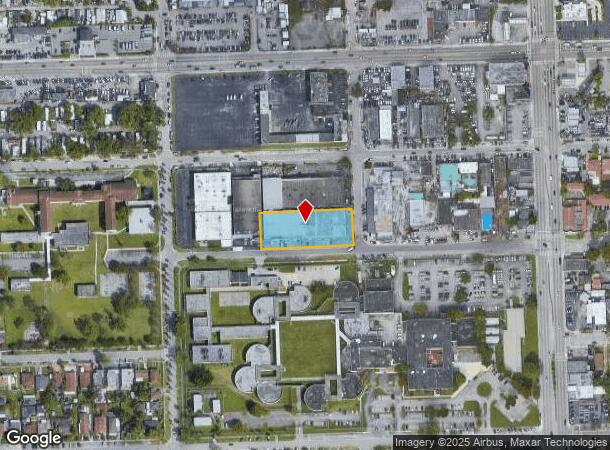
Property Record
2901 Nw 34Th St, Miami, FL 33142


Current Lease Availabilities
NEARBY LISTINGS FOR SALE OR LEASE
Property Detail
2901 Nw 34Th St
30-3128-000-0031
Acreage
Foodprocessing
28 53 41 .87 AC M/L S150FT OF SE1/4 OF NW1/4 OF NE1/4 OF NE1/4 LESS S25FT & LESS E25FT LOT SIZE 38125 SQUARE FEET OR 17682-2499 0697 1 COC 23978-3722 11 2005 1
X
Miami/Dade
12086C0311L
Florida
2024
0.88 AC
2025
South Central Miami
001704
South Florida
30,764 SF
Miami-Miami Beach-Kendall, FL
DEMOGRAPHICS near 2901 Nw 34Th St
1 Mile
3 Mile
5 Mile
2024 Total Population
22,192
233,677
632,332
2029 Population
21,506
228,276
620,072
Pop Growth 2024-2029
(3.09%)
(2.31%)
(1.94%)
Average Age
40
41
42
2024 Total Households
7,524
84,043
251,334
HH Growth 2024-2029
(3.60%)
(2.57%)
(1.96%)
Median Household Inc
$34,756
$34,816
$49,529
Avg Household Size
2.80
2.60
2.40
2024 Avg HH Vehicles
1.00
1.00
1.00
Median Home Value
$269,016
$316,484
$393,684
Median Year Built
1965
1965
1973
Nearby Places
- Restaurants
- Banks
- Shops
- Fitness
- Groceries
PUBLIC TRANSPORTATION
COMMUTER RAIL
Brownsville (Metrorail Green Line - Miami-Dade Transit (Metrorail/Metromover))
DRIVE
WALK
Distance
Brownsville (Metrorail Green Line - Miami-Dade Transit (Metrorail/Metromover))
3 min
1.2 mi
Earlington Heights (Metrorail Green Line - Miami-Dade Transit (Metrorail/Metromover))
DRIVE
WALK
Distance
Earlington Heights (Metrorail Green Line - Miami-Dade Transit (Metrorail/Metromover))
10 min
6.7 mi
AIRPORT
Miami International
DRIVE
WALK
Distance
Miami International
17 min
6.2 mi
Fort Lauderdale/Hollywood International
DRIVE
WALK
Distance
Fort Lauderdale/Hollywood International
33 min
22.8 mi
Freight Ports
Port of Miami
DRIVE
WALK
Distance
Port of Miami
15 min
7.2 mi
Nearby Properties
Address
Land Use
TOTAL SIZE
Lot Size
Zoning
Address
Land Use
TOTAL SIZE
Lot Size
Zoning
955,966 SF
38.91 AC
9600
Address
Land Use
TOTAL SIZE
Lot Size
Zoning
928,000 SF
14.30 AC
8000
Address
Land Use
TOTAL SIZE
Lot Size
Zoning
16.13 AC
6100
Address
Land Use
TOTAL SIZE
Lot Size
Zoning
2,789,683 SF
33.23 AC
7300
Address
Land Use
TOTAL SIZE
Lot Size
Zoning
2,403,353 SF
7.37 AC
6100
Address
Land Use
TOTAL SIZE
Lot Size
Zoning
256,089 SF
20.35 AC
7600
Address
Land Use
TOTAL SIZE
Lot Size
Zoning
585,775 SF
1.86 AC
6101
Address
Land Use
TOTAL SIZE
Lot Size
Zoning
570,694 SF
1.37 AC
4604
Address
Land Use
TOTAL SIZE
Lot Size
Zoning
566,165 SF
2.09 AC
6101
Address
Land Use
TOTAL SIZE
Lot Size
Zoning
996,100 SF
3.58 AC
9600
Address
Land Use
TOTAL SIZE
Lot Size
Zoning
627,685 SF
2.06 AC
6100
Address
Land Use
TOTAL SIZE
Lot Size
Zoning
328,554 SF
668.26 AC
8900
Address
Land Use
TOTAL SIZE
Lot Size
Zoning
428,154 SF
1.39 AC
6101
Address
Land Use
TOTAL SIZE
Lot Size
Zoning
596,081 SF
4.33 AC
9600
Address
Land Use
TOTAL SIZE
Lot Size
Zoning
1,212,604 SF
10.50 AC
9600
Address
Land Use
TOTAL SIZE
Lot Size
Zoning
648,350 SF
9.78 AC
6118
Address
Land Use
TOTAL SIZE
Lot Size
Zoning
526,358 SF
3.62 AC
6100
Address
Land Use
TOTAL SIZE
Lot Size
Zoning
545,220 SF
15.32 AC
6100
Address
Land Use
TOTAL SIZE
Lot Size
Zoning
498,242 SF
2.69 AC
6100
Address
Land Use
TOTAL SIZE
Lot Size
Zoning
480,664 SF
26.03 AC
9600
Address
Land Use
TOTAL SIZE
Lot Size
Zoning
474,561 SF
1.69 AC
6100
Address
Land Use
TOTAL SIZE
Lot Size
Zoning
499,370 SF
1.45 AC
7000
Address
Land Use
TOTAL SIZE
Lot Size
Zoning
306,775 SF
29.70 AC
7000
Address
Land Use
TOTAL SIZE
Lot Size
Zoning
299,169 SF
1.21 AC
6107
Address
Land Use
TOTAL SIZE
Lot Size
Zoning
451,817 SF
6400
Address
Land Use
TOTAL SIZE
Lot Size
Zoning
763,761 SF
8 AC
6402
Address
Land Use
TOTAL SIZE
Lot Size
Zoning
2 SF
154.10 AC
8900
Address
Land Use
TOTAL SIZE
Lot Size
Zoning
214,154 SF
0.66 AC
6100
Address
Land Use
TOTAL SIZE
Lot Size
Zoning
619,411 SF
7.33 AC
9600
Address
Land Use
TOTAL SIZE
Lot Size
Zoning
885,374 SF
20.59 AC
7300
The World's #1 Commercial Real Estate Marketplace
Connect with us
© 2025 CoStar Group
The information above has been obtained from sources believed reliable. While we do not doubt its accuracy we have not verified it and make no guarantee, warranty or representation about it. It is your responsibility to independently confirm its accuracy and completeness. Any projections, opinions, assumptions, or estimates used are for example only and do not represent the current or future performance of the property. The value of this transaction to you depends on tax and other factors which should be evaluated by your tax, financial, and legal advisors. You and your advisors should conduct a careful, independent investigation of the property to determine to your satisfaction the suitability of the property for your needs.