Property Record
2909 S Hampton Rd, Dallas, TX 75224
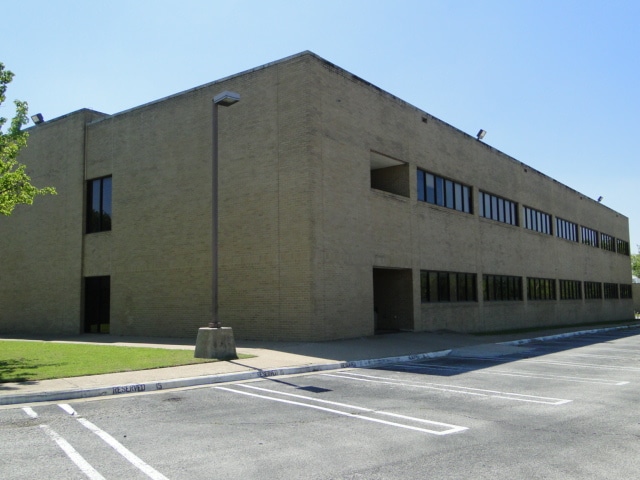

Property Detail
2909 S Hampton Rd
00C1280000II10000
DALLAS SOUTHWEST MEDICAL OFC BLDG BLK A/6030 PT LT 1 ACS 4.00 UNIT I 102 CE 3.7% INT202100390903 DD12072021 CO-DC 6030A000 001 2006030A000
Medicalbuilding
DALLAS
Z239
Texas
B and X Area of moderate flood hazard, usually the area between the limits of the 100-year and 500-year floods.
1
2024
4 AC
2025
Southwest Dallas
010804
Dallas/Ft Worth
13,878 SF
Dallas-Fort Worth-Arlington, TX
NEARBY LISTINGS FOR SALE OR LEASE
DEMOGRAPHICS near 2909 S Hampton Rd
1 mile
3 mile
5 mile
2025 Total Population
16,789
151,011
313,844
2030 Population
17,175
155,215
323,707
Pop Growth 2025-2030
+ 2.30%
+ 2.78%
+ 3.14%
Average Age
36
37
36
2025 Total Households
5,138
48,361
105,239
HH Growth 2025-2030
+ 2.30%
+ 2.92%
+ 3.30%
Median Household Inc
$64,271
$60,065
$56,995
Avg Household Size
3.20
3.00
2.90
2025 Avg HH Vehicles
2.00
2.00
2.00
Median Home Value
$254,414
$265,025
$249,626
Median Year Built
1957
1960
1968
Nearby Places
Map Layers
Map Styles
 Street
 Aerial
Layers
 Traffic
 Biking
Places
Listings with unknown addresses are not visible on the map
- Restaurants
- Banks
- Shops
- Fitness
- Groceries
PUBLIC TRANSPORTATION
TRANSIT/SUBWAY
Hampton Station (DART LIGHT RAIL - RED LINE - Dallas Area Rapid Transit (DART))
Drive
Walk
Distance
Hampton Station (DART LIGHT RAIL - RED LINE - Dallas Area Rapid Transit (DART))
3 min
17 min
0.9 mi
COMMUTER RAIL
Medical/Market Ctr Station (TRINITY RAILWAY - Dallas Area Rapid Transit (DART))
Drive
Walk
Distance
Medical/Market Ctr Station (TRINITY RAILWAY - Dallas Area Rapid Transit (DART))
16 min
7.5 mi
Victory Station (DART LIGHT RAIL - GREEN LINE - Dallas Area Rapid Transit (DART), DART LIGHT RAIL - ORANGE LINE - Dallas Area Rapid Transit (DART), TRINITY RAILWAY - Dallas Area Rapid Transit (DART))
Drive
Walk
Distance
Victory Station (DART LIGHT RAIL - GREEN LINE - Dallas Area Rapid Transit (DART), DART LIGHT RAIL - ORANGE LINE - Dallas Area Rapid Transit (DART), TRINITY RAILWAY - Dallas Area Rapid Transit (DART))
12 min
7.7 mi
AIRPORT
Dallas Love Field
Drive
Walk
Distance
Dallas Love Field
21 min
10.0 mi
Dallas-Fort Worth International
Drive
Walk
Distance
Dallas-Fort Worth International
34 min
23.2 mi
Freight Ports
Port of Shreveport
Drive
Walk
Distance
Port of Shreveport
221 min
202.7 mi
SALE & LEASE HISTORY
LISTING DATE
SALE/LEASE

Oct 30, 2022
For Lease
Nov 15, 2023
For Sale
May 23, 2017
For Sale
Feb 26, 2024
For Sale
Nearby Properties
Address
Land Use
TOTAL SIZE
Lot Size
Zoning
Address
Land Use
TOTAL SIZE
Lot Size
Zoning
271,956 SF
23.18 AC
Z298
Address
Land Use
TOTAL SIZE
Lot Size
Zoning
344,801 SF
7.24 AC
Z125
Address
Land Use
TOTAL SIZE
Lot Size
Zoning
192,086 SF
27.05 AC
Z125
Address
Land Use
TOTAL SIZE
Lot Size
Zoning
343,006 SF
0.53 AC
Z239
Address
Land Use
TOTAL SIZE
Lot Size
Zoning
8,727 SF
28.76 AC
Z298
Address
Land Use
TOTAL SIZE
Lot Size
Zoning
260,602 SF
6.64 AC
Address
Land Use
TOTAL SIZE
Lot Size
Zoning
333,215 SF
3.04 AC
Address
Land Use
TOTAL SIZE
Lot Size
Zoning
552,991 SF
34.27 AC
Z164
Address
Land Use
TOTAL SIZE
Lot Size
Zoning
286,203 SF
1.37 AC
Z239
Address
Land Use
TOTAL SIZE
Lot Size
Zoning
532,726 SF
64.28 AC
Z248
Address
Land Use
TOTAL SIZE
Lot Size
Zoning
291,174 SF
9.49 AC
Z239
Address
Land Use
TOTAL SIZE
Lot Size
Zoning
164,120 SF
15.85 AC
Z163
Address
Land Use
TOTAL SIZE
Lot Size
Zoning
472,800 SF
27.19 AC
Z116
Address
Land Use
TOTAL SIZE
Lot Size
Zoning
236,300 SF
4.76 AC
Z239
Address
Land Use
TOTAL SIZE
Lot Size
Zoning
389,900 SF
22.88 AC
Z298
Address
Land Use
TOTAL SIZE
Lot Size
Zoning
138,645 SF
195.45 AC
Z298
Address
Land Use
TOTAL SIZE
Lot Size
Zoning
312,118 SF
8.26 AC
Z166
Address
Land Use
TOTAL SIZE
Lot Size
Zoning
131,904 SF
11.99 AC
Z297
Address
Land Use
TOTAL SIZE
Lot Size
Zoning
414,118 SF
49.01 AC
Z294
Address
Land Use
TOTAL SIZE
Lot Size
Zoning
73,485 SF
3.29 AC
Z297
Address
Land Use
TOTAL SIZE
Lot Size
Zoning
146,912 SF
2.74 AC
Z239
Address
Land Use
TOTAL SIZE
Lot Size
Zoning
248,376 SF
15.62 AC
Z164
Address
Land Use
TOTAL SIZE
Lot Size
Zoning
142,616 SF
13.99 AC
Z125
Address
Land Use
TOTAL SIZE
Lot Size
Zoning
273,300 SF
12.52 AC
Z164
Address
Land Use
TOTAL SIZE
Lot Size
Zoning
330,000 SF
24.76 AC
Z116
Address
Land Use
TOTAL SIZE
Lot Size
Zoning
206,202 SF
11.18 AC
Z163
Address
Land Use
TOTAL SIZE
Lot Size
Zoning
211,022 SF
5.89 AC
Z239
Address
Land Use
TOTAL SIZE
Lot Size
Zoning
324,000 SF
21.75 AC
Z116
Address
Land Use
TOTAL SIZE
Lot Size
Zoning
96,401 SF
12.97 AC
Z248
Address
Land Use
TOTAL SIZE
Lot Size
Zoning
178,050 SF
7.38 AC
Z164
The World's #1 Commercial Real Estate Marketplace
Connect with us
© 2026 CoStar Group
The information above has been obtained from sources believed reliable. While we do not doubt its accuracy we have not verified it and make no guarantee, warranty or representation about it. It is your responsibility to independently confirm its accuracy and completeness. Any projections, opinions, assumptions, or estimates used are for example only and do not represent the current or future performance of the property. The value of this transaction to you depends on tax and other factors which should be evaluated by your tax, financial, and legal advisors. You and your advisors should conduct a careful, independent investigation of the property to determine to your satisfaction the suitability of the property for your needs.