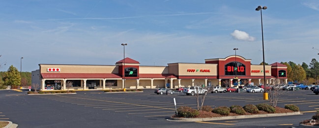
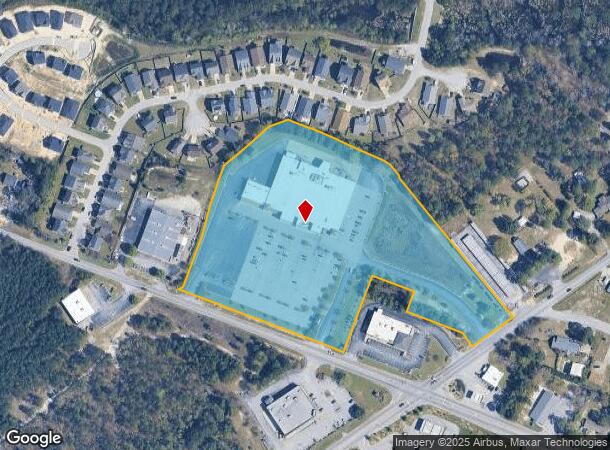
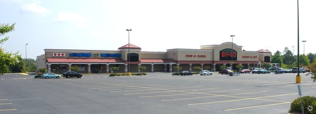
Property Record
2916 Emanuel Church Rd, West Columbia, SC 29170
NEARBY LISTINGS FOR SALE OR LEASE
Property Detail
2916 Emanuel Church Rd
Stripcommercialcenter
Lexington
X
South Carolina
45063C0258J
10.35 AC
2025
Cayce/West Columbia
2024
Columbia
021033
Columbia, SC
52,096 SF
005599-05-050
DEMOGRAPHICS near 2916 Emanuel Church Rd
1 Mile
3 Mile
5 Mile
2024 Total Population
5,706
28,453
80,675
2029 Population
6,166
30,899
87,975
Pop Growth 2024-2029
+ 8.06%
+ 8.60%
+ 9.05%
Average Age
39
39
40
2024 Total Households
2,276
11,323
32,480
HH Growth 2024-2029
+ 8.22%
+ 8.76%
+ 9.22%
Median Household Inc
$70,383
$67,436
$65,223
Avg Household Size
2.50
2.50
2.40
2024 Avg HH Vehicles
2.00
2.00
2.00
Median Home Value
$153,840
$156,415
$169,737
Median Year Built
1994
1991
1992
Nearby Places
Map Layers
Map Styles
 Street
 Aerial
- Restaurants
- Banks
- Shops
- Fitness
- Groceries
PUBLIC TRANSPORTATION
COMMUTER RAIL
Columbia Amtrak Station (Silver Star - Amtrak)
DRIVE
WALK
Distance
Columbia Amtrak Station (Silver Star - Amtrak)
18 min
9.7 mi
AIRPORT
Columbia Metro
DRIVE
WALK
Distance
Columbia Metro
16 min
4.1 mi
Freight Ports
North Charleston Terminal
DRIVE
WALK
Distance
North Charleston Terminal
123 min
106.0 mi
Nearby Properties
Address
Land Use
TOTAL SIZE
Lot Size
Zoning
Address
Land Use
TOTAL SIZE
Lot Size
Zoning
461,888 SF
61.50 AC
ID
Address
Land Use
TOTAL SIZE
Lot Size
Zoning
37,794 SF
22.37 AC
ID
Address
Land Use
TOTAL SIZE
Lot Size
Zoning
58.81 AC
RD
Address
Land Use
TOTAL SIZE
Lot Size
Zoning
257,688 SF
23.03 AC
ID
Address
Land Use
TOTAL SIZE
Lot Size
Zoning
41,860 SF
6.54 AC
ID
Address
Land Use
TOTAL SIZE
Lot Size
Zoning
318,309 SF
33.51 AC
ID
Address
Land Use
TOTAL SIZE
Lot Size
Zoning
70,740 SF
13 AC
ID
Address
Land Use
TOTAL SIZE
Lot Size
Zoning
59.61 AC
ID
Address
Land Use
TOTAL SIZE
Lot Size
Zoning
430.11 AC
ID
Address
Land Use
TOTAL SIZE
Lot Size
Zoning
8,269 SF
12.99 AC
RD
Address
Land Use
TOTAL SIZE
Lot Size
Zoning
10.52 AC
ID
Address
Land Use
TOTAL SIZE
Lot Size
Zoning
115,000 SF
11.99 AC
ID
Address
Land Use
TOTAL SIZE
Lot Size
Zoning
17,442 SF
2.78 AC
Address
Land Use
TOTAL SIZE
Lot Size
Zoning
54,092 SF
5.90 AC
ID
Address
Land Use
TOTAL SIZE
Lot Size
Zoning
95,730 SF
8.15 AC
ID
Address
Land Use
TOTAL SIZE
Lot Size
Zoning
11,425 SF
5.67 AC
ID
Address
Land Use
TOTAL SIZE
Lot Size
Zoning
16,160 SF
9 AC
ID
Address
Land Use
TOTAL SIZE
Lot Size
Zoning
10,286 SF
1.75 AC
ID
Address
Land Use
TOTAL SIZE
Lot Size
Zoning
42,842 SF
6.47 AC
ID
Address
Land Use
TOTAL SIZE
Lot Size
Zoning
96,736 SF
8.30 AC
Address
Land Use
TOTAL SIZE
Lot Size
Zoning
78.48 AC
ID
Address
Land Use
TOTAL SIZE
Lot Size
Zoning
10.48 AC
RD
Address
Land Use
TOTAL SIZE
Lot Size
Zoning
31,000 SF
7.49 AC
C2
Address
Land Use
TOTAL SIZE
Lot Size
Zoning
218.28 AC
RD
Address
Land Use
TOTAL SIZE
Lot Size
Zoning
21,261 SF
9.84 AC
ID
Address
Land Use
TOTAL SIZE
Lot Size
Zoning
6.44 AC
ID
Address
Land Use
TOTAL SIZE
Lot Size
Zoning
23,601 SF
6.98 AC
ID
Address
Land Use
TOTAL SIZE
Lot Size
Zoning
32,239 SF
2.66 AC
ID
Address
Land Use
TOTAL SIZE
Lot Size
Zoning
40,550 SF
3.95 AC
ID
The World's #1 Commercial Real Estate Marketplace
Connect with us
© 2025 CoStar Group
The information above has been obtained from sources believed reliable. While we do not doubt its accuracy we have not verified it and make no guarantee, warranty or representation about it. It is your responsibility to independently confirm its accuracy and completeness. Any projections, opinions, assumptions, or estimates used are for example only and do not represent the current or future performance of the property. The value of this transaction to you depends on tax and other factors which should be evaluated by your tax, financial, and legal advisors. You and your advisors should conduct a careful, independent investigation of the property to determine to your satisfaction the suitability of the property for your needs.