Property Record
2933 E Davis St, Conroe, TX 77301


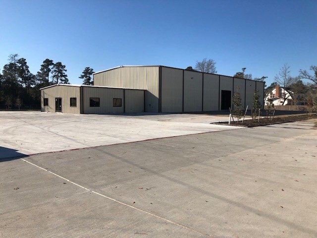
Property Detail
2933 E Davis St
0563-01-03510
A0563 - TOOPS JOHN, TRACT 35-A, ACRES 5.536
Commercialnec
MONTGOMERY
1
Texas
B and X Area of moderate flood hazard, usually the area between the limits of the 100-year and 500-year floods.
5.54 AC
2024
The Woodlands/Conroe
2025
Houston
693002
Houston-Pasadena-The Woodlands, TX
30,000 SF
NEARBY LISTINGS FOR SALE OR LEASE
DEMOGRAPHICS near 2933 E Davis St
1 mile
3 mile
5 mile
2024 Total Population
2,749
35,960
84,011
2029 Population
3,357
43,744
103,073
Pop Growth 2024-2029
+ 22.12%
+ 21.65%
+ 22.69%
Average Age
33
35
36
2024 Total Households
814
10,637
28,758
HH Growth 2024-2029
+ 22.24%
+ 22.91%
+ 23.25%
Median Household Inc
$80,357
$58,648
$61,349
Avg Household Size
3.30
3.10
2.80
2024 Avg HH Vehicles
2.00
2.00
2.00
Median Home Value
$232,143
$175,391
$226,890
Median Year Built
2010
1997
1999
Nearby Places
Map Layers
Map Styles
 Street
 Aerial
Transit
 Traffic
 Biking
Places
Listings with unknown addresses are not visible on the map
- Restaurants
- Banks
- Shops
- Fitness
- Groceries
PUBLIC TRANSPORTATION
AIRPORT
George Bush Intcntl/Houston
Drive
Walk
Distance
George Bush Intcntl/Houston
44 min
34.5 mi
Freight Ports
Port of Houston
Drive
Walk
Distance
Port of Houston
67 min
50.2 mi
SALE & LEASE HISTORY
LISTING DATE
SALE/LEASE

Jul 13, 2022
For Lease
Jan 19, 2018
For Lease
Nearby Properties
Address
Land Use
TOTAL SIZE
Lot Size
Zoning
Address
Land Use
TOTAL SIZE
Lot Size
Zoning
322,082 SF
36.56 AC
1
Address
Land Use
TOTAL SIZE
Lot Size
Zoning
398,842 SF
23.75 AC
1
Address
Land Use
TOTAL SIZE
Lot Size
Zoning
619,770 SF
81.76 AC
Address
Land Use
TOTAL SIZE
Lot Size
Zoning
191,700 SF
19.41 AC
1
Address
Land Use
TOTAL SIZE
Lot Size
Zoning
326,478 SF
20.22 AC
Address
Land Use
TOTAL SIZE
Lot Size
Zoning
206,008 SF
107.61 AC
Address
Land Use
TOTAL SIZE
Lot Size
Zoning
376,980 SF
24.37 AC
1
Address
Land Use
TOTAL SIZE
Lot Size
Zoning
242,944 SF
179.58 AC
Address
Land Use
TOTAL SIZE
Lot Size
Zoning
186,100 SF
29.68 AC
1
Address
Land Use
TOTAL SIZE
Lot Size
Zoning
192,624 SF
25.16 AC
Address
Land Use
TOTAL SIZE
Lot Size
Zoning
82,078 SF
61.15 AC
1
Address
Land Use
TOTAL SIZE
Lot Size
Zoning
262,564 SF
51.89 AC
1
Address
Land Use
TOTAL SIZE
Lot Size
Zoning
86,634 SF
15.72 AC
Address
Land Use
TOTAL SIZE
Lot Size
Zoning
92,160 SF
0.82 AC
1
Address
Land Use
TOTAL SIZE
Lot Size
Zoning
118,897 SF
11.01 AC
Address
Land Use
TOTAL SIZE
Lot Size
Zoning
38,742 SF
249.26 AC
1
Address
Land Use
TOTAL SIZE
Lot Size
Zoning
159,185 SF
18.45 AC
1
Address
Land Use
TOTAL SIZE
Lot Size
Zoning
117,392 SF
27 AC
1
Address
Land Use
TOTAL SIZE
Lot Size
Zoning
213,043 SF
15.95 AC
Address
Land Use
TOTAL SIZE
Lot Size
Zoning
143,641 SF
14.80 AC
1
Address
Land Use
TOTAL SIZE
Lot Size
Zoning
161,142 SF
493.71 AC
Address
Land Use
TOTAL SIZE
Lot Size
Zoning
271,500 SF
0.97 AC
1
Address
Land Use
TOTAL SIZE
Lot Size
Zoning
187,426 SF
61.77 AC
1
Address
Land Use
TOTAL SIZE
Lot Size
Zoning
35,026 SF
3.24 AC
Address
Land Use
TOTAL SIZE
Lot Size
Zoning
82,280 SF
9.60 AC
1
Address
Land Use
TOTAL SIZE
Lot Size
Zoning
89,792 SF
1.44 AC
1
Address
Land Use
TOTAL SIZE
Lot Size
Zoning
166,846 SF
2.92 AC
1
Address
Land Use
TOTAL SIZE
Lot Size
Zoning
77,046 SF
0.77 AC
1
Address
Land Use
TOTAL SIZE
Lot Size
Zoning
70,912 SF
5.07 AC
1
Address
Land Use
TOTAL SIZE
Lot Size
Zoning
198,512 SF
0.72 AC
1
The World's #1 Commercial Real Estate Marketplace
Connect with us
© 2026 CoStar Group
The information above has been obtained from sources believed reliable. While we do not doubt its accuracy we have not verified it and make no guarantee, warranty or representation about it. It is your responsibility to independently confirm its accuracy and completeness. Any projections, opinions, assumptions, or estimates used are for example only and do not represent the current or future performance of the property. The value of this transaction to you depends on tax and other factors which should be evaluated by your tax, financial, and legal advisors. You and your advisors should conduct a careful, independent investigation of the property to determine to your satisfaction the suitability of the property for your needs.