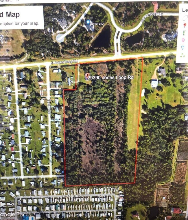
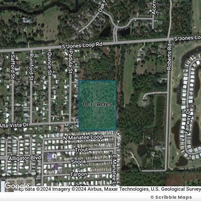
Property Record
29390 Jones Loop Rd, Punta Gorda, FL 33950


NEARBY LISTINGS FOR SALE OR LEASE
-
-
-
No Photo
-
-
-
-
-
View all Punta Gorda listings for sale on LoopNet.com
Property Detail
29390 Jones Loop Rd
Punta Gorda, FL
Acreage
412327176002
Charlotte
Sfr
Florida
X
14.20 AC
12015C0244G
Charlotte County
1,274 SF
Southwest Florida
DEMOGRAPHICS near 29390 Jones Loop Rd
1 Mile
3 Mile
5 Mile
2024 Total Population
3,516
12,723
34,308
2029 Population
4,192
15,197
41,341
Pop Growth 2024-2029
+ 19.23%
+ 19.45%
+ 20.50%
Average Age
55
56
57
2024 Total Households
1,544
5,868
16,622
HH Growth 2024-2029
+ 19.69%
+ 19.79%
+ 20.78%
Median Household Inc
$57,702
$65,447
$57,981
Avg Household Size
2.00
2.10
2.00
2024 Avg HH Vehicles
2.00
2.00
2.00
Median Home Value
$150,374
$272,699
$295,049
Median Year Built
2000
1997
1994
Nearby Places
Map Layers
Map Styles
 Street
 Aerial
- Restaurants
- Banks
- Shops
- Fitness
- Groceries
PUBLIC TRANSPORTATION
AIRPORT
Punta Gorda
DRIVE
WALK
Distance
Punta Gorda
8 min
3.4 mi
Southwest Florida International
DRIVE
WALK
Distance
Southwest Florida International
42 min
33.3 mi
Freight Ports
Port Manatee
DRIVE
WALK
Distance
Port Manatee
89 min
75.1 mi
SALE & LEASE HISTORY
LISTING DATE
SALE/LEASE

Jun 08, 2023
For Sale
Apr 29, 2022
For Sale
Nearby Properties
Address
Land Use
TOTAL SIZE
Lot Size
Zoning
Address
Land Use
TOTAL SIZE
Lot Size
Zoning
164,121 SF
44.20 AC
ECAP
Address
Land Use
TOTAL SIZE
Lot Size
Zoning
265,949 SF
22.80 AC
PD-CC
Address
Land Use
TOTAL SIZE
Lot Size
Zoning
253,440 SF
30.47 AC
ECAP
Address
Land Use
TOTAL SIZE
Lot Size
Zoning
378,000 SF
29.24 AC
ECAP
Address
Land Use
TOTAL SIZE
Lot Size
Zoning
345,043 SF
33.12 AC
ECAP
Address
Land Use
TOTAL SIZE
Lot Size
Zoning
62,415 SF
281.65 AC
ECAP
Address
Land Use
TOTAL SIZE
Lot Size
Zoning
198,916 SF
25.79 AC
HC
Address
Land Use
TOTAL SIZE
Lot Size
Zoning
385,350 SF
374.81 AC
ECAP
Address
Land Use
TOTAL SIZE
Lot Size
Zoning
142,812 SF
7.89 AC
HC
Address
Land Use
TOTAL SIZE
Lot Size
Zoning
96,845 SF
17.62 AC
HC
Address
Land Use
TOTAL SIZE
Lot Size
Zoning
8,406 SF
31.48 AC
ECAP
Address
Land Use
TOTAL SIZE
Lot Size
Zoning
136.11 AC
ECAP
Address
Land Use
TOTAL SIZE
Lot Size
Zoning
104,398 SF
12.97 AC
HC
Address
Land Use
TOTAL SIZE
Lot Size
Zoning
13,260 SF
2.27 AC
CG
Address
Land Use
TOTAL SIZE
Lot Size
Zoning
65,396 SF
5.13 AC
HC
Address
Land Use
TOTAL SIZE
Lot Size
Zoning
63,770 SF
5 AC
ECAP
Address
Land Use
TOTAL SIZE
Lot Size
Zoning
65,141 SF
9.56 AC
HC
Address
Land Use
TOTAL SIZE
Lot Size
Zoning
15,134 SF
2.03 AC
CG
Address
Land Use
TOTAL SIZE
Lot Size
Zoning
60,000 SF
1.44 AC
ECAP
Address
Land Use
TOTAL SIZE
Lot Size
Zoning
52,818 SF
16.78 AC
P
Address
Land Use
TOTAL SIZE
Lot Size
Zoning
40,000 SF
20 AC
ECAP
Address
Land Use
TOTAL SIZE
Lot Size
Zoning
18.93 AC
HC
Address
Land Use
TOTAL SIZE
Lot Size
Zoning
68,773 SF
8.05 AC
ECAP
Address
Land Use
TOTAL SIZE
Lot Size
Zoning
43,500 SF
9.84 AC
CG
Address
Land Use
TOTAL SIZE
Lot Size
Zoning
17.81 AC
HC
Address
Land Use
TOTAL SIZE
Lot Size
Zoning
21,583 SF
590.79 AC
ES
Address
Land Use
TOTAL SIZE
Lot Size
Zoning
Address
Land Use
TOTAL SIZE
Lot Size
Zoning
12,408 SF
1.92 AC
CG
Address
Land Use
TOTAL SIZE
Lot Size
Zoning
21,936 SF
175.75 AC
GS-3.5
Address
Land Use
TOTAL SIZE
Lot Size
Zoning
22,597 SF
3.43 AC
HC
The World's #1 Commercial Real Estate Marketplace
Connect with us
© 2025 CoStar Group
The information above has been obtained from sources believed reliable. While we do not doubt its accuracy we have not verified it and make no guarantee, warranty or representation about it. It is your responsibility to independently confirm its accuracy and completeness. Any projections, opinions, assumptions, or estimates used are for example only and do not represent the current or future performance of the property. The value of this transaction to you depends on tax and other factors which should be evaluated by your tax, financial, and legal advisors. You and your advisors should conduct a careful, independent investigation of the property to determine to your satisfaction the suitability of the property for your needs.