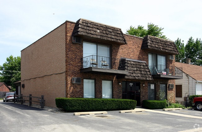
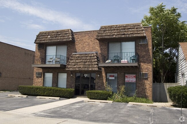
Property Record
2940 Bernice Rd, Lansing, IL 60438


Property Detail
2940 Bernice Rd
Chicago-Naperville-Elgin, IL-IN
(HARLANDS) SOUTH (CHICAGO) ADD TO (BERNICE) SUB S 174 FT OF SW NE SEC 30-36-15
30-30-220-019-0000
Cook
Miscresidentialimprovement
Illinois
B and X Area of moderate flood hazard, usually the area between the limits of the 100-year and 500-year floods.
6
2023
0.14 AC
2025
Near South Cook
827902
Chicago
2,960 SF
NEARBY LISTINGS FOR SALE OR LEASE
DEMOGRAPHICS near 2940 Bernice Rd
1 mile
3 mile
5 mile
2025 Total Population
13,584
103,377
243,262
2030 Population
13,724
104,062
244,252
Pop Growth 2025-2030
+ 1.03%
+ 0.66%
+ 0.41%
Average Age
40
41
40
2025 Total Households
5,004
39,538
91,995
HH Growth 2025-2030
+ 0.90%
+ 0.47%
+ 0.24%
Median Household Inc
$62,023
$65,050
$65,752
Avg Household Size
2.60
2.50
2.50
2025 Avg HH Vehicles
2.00
2.00
2.00
Median Home Value
$146,494
$181,512
$182,695
Median Year Built
1960
1961
1963
Nearby Places
Map Layers
Map Styles
 Street
 Aerial
Layers
 Traffic
 Biking
Places
Listings with unknown addresses are not visible on the map
- Restaurants
- Banks
- Shops
- Fitness
- Groceries
PUBLIC TRANSPORTATION
COMMUTER RAIL
Hegewisch Station (South Shore Line - Northern Indiana Commuter Transportation District (South Shore Line))
Drive
Walk
Distance
Hegewisch Station (South Shore Line - Northern Indiana Commuter Transportation District (South Shore Line))
10 min
5.0 mi
Drive
Walk
Distance
14 min
6.3 mi
AIRPORT
Chicago Midway International
Drive
Walk
Distance
Chicago Midway International
37 min
23.2 mi
Chicago O'Hare International
Drive
Walk
Distance
Chicago O'Hare International
79 min
45.2 mi
Nearby Properties
Address
Land Use
TOTAL SIZE
Lot Size
Zoning
Address
Land Use
TOTAL SIZE
Lot Size
Zoning
879,191 SF
13.93 AC
Address
Land Use
TOTAL SIZE
Lot Size
Zoning
125,938 SF
13.32 AC
Address
Land Use
TOTAL SIZE
Lot Size
Zoning
350,110 SF
24.01 AC
R33
Address
Land Use
TOTAL SIZE
Lot Size
Zoning
668,326 SF
26.90 AC
Address
Land Use
TOTAL SIZE
Lot Size
Zoning
197,080 SF
R33
Address
Land Use
TOTAL SIZE
Lot Size
Zoning
82,736 SF
0.37 AC
Address
Land Use
TOTAL SIZE
Lot Size
Zoning
24.56 AC
Address
Land Use
TOTAL SIZE
Lot Size
Zoning
Address
Land Use
TOTAL SIZE
Lot Size
Zoning
97,046 SF
3.36 AC
Address
Land Use
TOTAL SIZE
Lot Size
Zoning
126,648 SF
3.71 AC
Address
Land Use
TOTAL SIZE
Lot Size
Zoning
115,612 SF
4.20 AC
Address
Land Use
TOTAL SIZE
Lot Size
Zoning
140,360 SF
15 AC
R33
Address
Land Use
TOTAL SIZE
Lot Size
Zoning
135,617 SF
7.80 AC
Address
Land Use
TOTAL SIZE
Lot Size
Zoning
251,700 SF
19.86 AC
Address
Land Use
TOTAL SIZE
Lot Size
Zoning
186,608 SF
18.11 AC
R3
Address
Land Use
TOTAL SIZE
Lot Size
Zoning
82,272 SF
12.55 AC
R3
Address
Land Use
TOTAL SIZE
Lot Size
Zoning
52,731 SF
2.24 AC
R33
Address
Land Use
TOTAL SIZE
Lot Size
Zoning
94,500 SF
2.68 AC
Address
Land Use
TOTAL SIZE
Lot Size
Zoning
244,310 SF
9.32 AC
Address
Land Use
TOTAL SIZE
Lot Size
Zoning
87,166 SF
7.82 AC
Address
Land Use
TOTAL SIZE
Lot Size
Zoning
106,840 SF
6.62 AC
R33
Address
Land Use
TOTAL SIZE
Lot Size
Zoning
36,704 SF
3.12 AC
Address
Land Use
TOTAL SIZE
Lot Size
Zoning
118,120 SF
4.70 AC
Address
Land Use
TOTAL SIZE
Lot Size
Zoning
117,855 SF
8.51 AC
Address
Land Use
TOTAL SIZE
Lot Size
Zoning
149,623 SF
4.93 AC
Address
Land Use
TOTAL SIZE
Lot Size
Zoning
5.01 AC
Address
Land Use
TOTAL SIZE
Lot Size
Zoning
122,628 SF
9.40 AC
Address
Land Use
TOTAL SIZE
Lot Size
Zoning
120,033 SF
30.10 AC
Address
Land Use
TOTAL SIZE
Lot Size
Zoning
41,928 SF
3.71 AC
Address
Land Use
TOTAL SIZE
Lot Size
Zoning
102,264 SF
8.61 AC
R3
The World's #1 Commercial Real Estate Marketplace
Connect with us
© 2026 CoStar Group
The information above has been obtained from sources believed reliable. While we do not doubt its accuracy we have not verified it and make no guarantee, warranty or representation about it. It is your responsibility to independently confirm its accuracy and completeness. Any projections, opinions, assumptions, or estimates used are for example only and do not represent the current or future performance of the property. The value of this transaction to you depends on tax and other factors which should be evaluated by your tax, financial, and legal advisors. You and your advisors should conduct a careful, independent investigation of the property to determine to your satisfaction the suitability of the property for your needs.