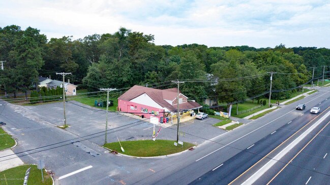
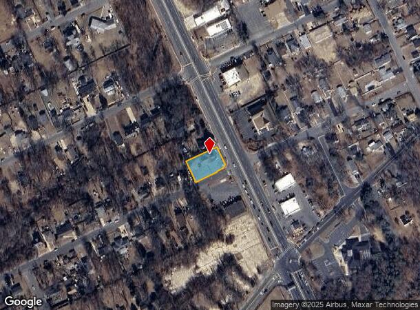
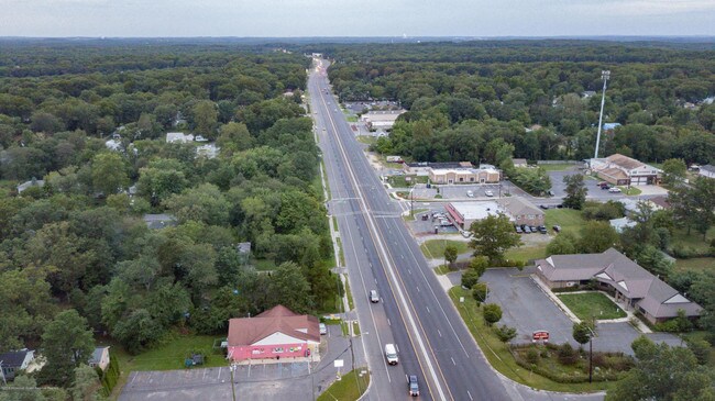
Property Record
2940 Us Highway 9, Howell, NJ 07731
NEARBY LISTINGS FOR SALE OR LEASE
Property Detail
2940 Us Highway 9
21-00115-0000-00021
Freewood Acres
Storebuilding
Monmouth
X
New Jersey
34025C0311F
21
2024
0.36 AC
2025
Western Monmouth
811301
Northern New Jersey
2,200 SF
New York-Jersey City-White Plains, NY-NJ
DEMOGRAPHICS near 2940 Us Highway 9
1 Mile
3 Mile
5 Mile
2024 Total Population
4,523
40,140
104,699
2029 Population
4,491
40,280
106,336
Pop Growth 2024-2029
(0.71%)
+ 0.35%
+ 1.56%
Average Age
41
40
37
2024 Total Households
1,583
13,361
33,325
HH Growth 2024-2029
(0.88%)
(0.21%)
+ 0.89%
Median Household Inc
$98,704
$119,908
$99,832
Avg Household Size
2.80
2.90
2.90
2024 Avg HH Vehicles
2.00
2.00
2.00
Median Home Value
$408,558
$398,337
$405,453
Median Year Built
1979
1981
1983
Nearby Places
Map Layers
Map Styles
 Street
 Aerial
- Restaurants
- Banks
- Shops
- Fitness
- Groceries
SALE & LEASE HISTORY
LISTING DATE
SALE/LEASE

Sep 10, 2018
For Sale
Nearby Properties
Address
Land Use
TOTAL SIZE
Lot Size
Zoning
Address
Land Use
TOTAL SIZE
Lot Size
Zoning
36,678 SF
38.75 AC
MFAH
Address
Land Use
TOTAL SIZE
Lot Size
Zoning
161,340 SF
35.35 AC
HD-1
Address
Land Use
TOTAL SIZE
Lot Size
Zoning
25.63 AC
HD-1
Address
Land Use
TOTAL SIZE
Lot Size
Zoning
14.90 AC
PFE
Address
Land Use
TOTAL SIZE
Lot Size
Zoning
136,800 SF
14.08 AC
ARE1
Address
Land Use
TOTAL SIZE
Lot Size
Zoning
28.99 AC
HD-1
Address
Land Use
TOTAL SIZE
Lot Size
Zoning
120,000 SF
77 AC
ARE2
Address
Land Use
TOTAL SIZE
Lot Size
Zoning
43.22 AC
ARE2
Address
Land Use
TOTAL SIZE
Lot Size
Zoning
70.60 AC
RE
Address
Land Use
TOTAL SIZE
Lot Size
Zoning
98,731 SF
13.65 AC
HD
Address
Land Use
TOTAL SIZE
Lot Size
Zoning
117,975 SF
21.20 AC
HD-1
Address
Land Use
TOTAL SIZE
Lot Size
Zoning
141,437 SF
13.35 AC
HD-1
Address
Land Use
TOTAL SIZE
Lot Size
Zoning
125,379 SF
22.16 AC
HD
Address
Land Use
TOTAL SIZE
Lot Size
Zoning
58.80 AC
R-E
Address
Land Use
TOTAL SIZE
Lot Size
Zoning
51,531 SF
13.30 AC
HD
Address
Land Use
TOTAL SIZE
Lot Size
Zoning
24,630 SF
6.93 AC
HD-1
Address
Land Use
TOTAL SIZE
Lot Size
Zoning
94,480 SF
11.11 AC
HD-1
Address
Land Use
TOTAL SIZE
Lot Size
Zoning
5.08 AC
NC
Address
Land Use
TOTAL SIZE
Lot Size
Zoning
123,578 SF
9.28 AC
HD-1
Address
Land Use
TOTAL SIZE
Lot Size
Zoning
46.70 AC
R-E
Address
Land Use
TOTAL SIZE
Lot Size
Zoning
66,768 SF
10.90 AC
ARE2
Address
Land Use
TOTAL SIZE
Lot Size
Zoning
2,104 SF
22.90 AC
MHP
Address
Land Use
TOTAL SIZE
Lot Size
Zoning
52,985 SF
20.92 AC
HD-1
Address
Land Use
TOTAL SIZE
Lot Size
Zoning
2,040 SF
40.11 AC
R-80
Address
Land Use
TOTAL SIZE
Lot Size
Zoning
35.06 AC
HD-1
Address
Land Use
TOTAL SIZE
Lot Size
Zoning
30,529 SF
1.41 AC
HD-1
Address
Land Use
TOTAL SIZE
Lot Size
Zoning
69,465 SF
7.70 AC
HD-1
Address
Land Use
TOTAL SIZE
Lot Size
Zoning
34.92 AC
R-E
Address
Land Use
TOTAL SIZE
Lot Size
Zoning
78,528 SF
6.21 AC
R-3
Address
Land Use
TOTAL SIZE
Lot Size
Zoning
600 SF
12.47 AC
RMLD
The World's #1 Commercial Real Estate Marketplace
Connect with us
© 2025 CoStar Group
The information above has been obtained from sources believed reliable. While we do not doubt its accuracy we have not verified it and make no guarantee, warranty or representation about it. It is your responsibility to independently confirm its accuracy and completeness. Any projections, opinions, assumptions, or estimates used are for example only and do not represent the current or future performance of the property. The value of this transaction to you depends on tax and other factors which should be evaluated by your tax, financial, and legal advisors. You and your advisors should conduct a careful, independent investigation of the property to determine to your satisfaction the suitability of the property for your needs.