Property Record
29423 Highway 160, Durango, CO 81301
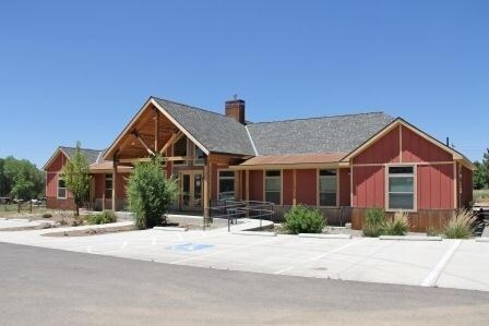

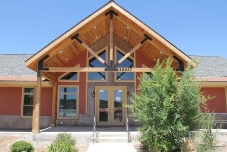
Property Detail
29423 Highway 160
Durango, CO
SUBDIVISION: PINON ACRES S/D BLOCK: 0 LOT: 19 PINON ACRES SUB 29423 E US HWY 160 DURANGO 81301
R011506
La Plata
Officebuilding
Colorado
B and X Area of moderate flood hazard, usually the area between the limits of the 100-year and 500-year floods.
19
2024
2.25 AC
2025
Colorado Southwest Area
970703
Other Market Areas
3,323 SF
NEARBY LISTINGS FOR SALE OR LEASE
DEMOGRAPHICS near 29423 Highway 160
1 mile
3 mile
5 mile
2025 Total Population
1,916
4,644
12,667
2030 Population
1,917
4,630
12,595
Pop Growth 2025-2030
+ 0.05%
(0.30%)
(0.57%)
Average Age
41
41
40
2025 Total Households
806
1,967
5,429
HH Growth 2025-2030
(0.12%)
(0.31%)
(0.76%)
Median Household Inc
$99,575
$105,661
$92,180
Avg Household Size
2.30
2.30
2.20
2025 Avg HH Vehicles
2.00
2.00
2.00
Median Home Value
$732,276
$658,858
$680,985
Median Year Built
2000
1998
1990
Nearby Places
Map Layers
Map Styles
 Street
 Aerial
Transit
 Traffic
 Biking
Places
Listings with unknown addresses are not visible on the map
- Restaurants
- Banks
- Shops
- Fitness
- Groceries
PUBLIC TRANSPORTATION
AIRPORT
Durango-La Plata County
Drive
Walk
Distance
Durango-La Plata County
13 min
7.9 mi
Freight Ports
Port of San Diego
Drive
Walk
Distance
Port of San Diego
931 min
810.7 mi
SALE & LEASE HISTORY
LISTING DATE
SALE/LEASE

Feb 13, 2018
For Sale
Nearby Properties
Address
Land Use
TOTAL SIZE
Lot Size
Zoning
Address
Land Use
TOTAL SIZE
Lot Size
Zoning
309,540 SF
49.68 AC
Address
Land Use
TOTAL SIZE
Lot Size
Zoning
151,412 SF
2.60 AC
Address
Land Use
TOTAL SIZE
Lot Size
Zoning
108,918 SF
27.44 AC
Address
Land Use
TOTAL SIZE
Lot Size
Zoning
180,591 SF
13.50 AC
Address
Land Use
TOTAL SIZE
Lot Size
Zoning
58,393 SF
10.20 AC
Address
Land Use
TOTAL SIZE
Lot Size
Zoning
42,714 SF
2.05 AC
Address
Land Use
TOTAL SIZE
Lot Size
Zoning
93,332 SF
10.49 AC
Address
Land Use
TOTAL SIZE
Lot Size
Zoning
10,928 SF
15.53 AC
Address
Land Use
TOTAL SIZE
Lot Size
Zoning
61,035 SF
9.64 AC
Address
Land Use
TOTAL SIZE
Lot Size
Zoning
93,696 SF
3.47 AC
Address
Land Use
TOTAL SIZE
Lot Size
Zoning
26,379 SF
0.84 AC
Address
Land Use
TOTAL SIZE
Lot Size
Zoning
8,003 SF
1.50 AC
Address
Land Use
TOTAL SIZE
Lot Size
Zoning
8,771 SF
2.31 AC
Address
Land Use
TOTAL SIZE
Lot Size
Zoning
52,185 SF
2.92 AC
Address
Land Use
TOTAL SIZE
Lot Size
Zoning
92,058 SF
3.61 AC
Address
Land Use
TOTAL SIZE
Lot Size
Zoning
22,180 SF
0.78 AC
Address
Land Use
TOTAL SIZE
Lot Size
Zoning
5,629 SF
4.31 AC
Address
Land Use
TOTAL SIZE
Lot Size
Zoning
21,574 SF
5.77 AC
Address
Land Use
TOTAL SIZE
Lot Size
Zoning
18,327 SF
4.21 AC
Address
Land Use
TOTAL SIZE
Lot Size
Zoning
15,560 SF
2.71 AC
Address
Land Use
TOTAL SIZE
Lot Size
Zoning
22,367 SF
2.75 AC
Address
Land Use
TOTAL SIZE
Lot Size
Zoning
29,066 SF
1.63 AC
Address
Land Use
TOTAL SIZE
Lot Size
Zoning
29,760 SF
4.54 AC
Address
Land Use
TOTAL SIZE
Lot Size
Zoning
18,545 SF
6.85 AC
Address
Land Use
TOTAL SIZE
Lot Size
Zoning
6,552 SF
8.57 AC
Address
Land Use
TOTAL SIZE
Lot Size
Zoning
17,422 SF
1.08 AC
Address
Land Use
TOTAL SIZE
Lot Size
Zoning
58,290 SF
2.01 AC
Address
Land Use
TOTAL SIZE
Lot Size
Zoning
3.72 AC
Address
Land Use
TOTAL SIZE
Lot Size
Zoning
35,150 SF
2.61 AC
Address
Land Use
TOTAL SIZE
Lot Size
Zoning
14,888 SF
2.30 AC
The World's #1 Commercial Real Estate Marketplace
Connect with us
© 2026 CoStar Group
The information above has been obtained from sources believed reliable. While we do not doubt its accuracy we have not verified it and make no guarantee, warranty or representation about it. It is your responsibility to independently confirm its accuracy and completeness. Any projections, opinions, assumptions, or estimates used are for example only and do not represent the current or future performance of the property. The value of this transaction to you depends on tax and other factors which should be evaluated by your tax, financial, and legal advisors. You and your advisors should conduct a careful, independent investigation of the property to determine to your satisfaction the suitability of the property for your needs.