Property Record
2954 Brighton 3Rd St, Brooklyn, NY 11235
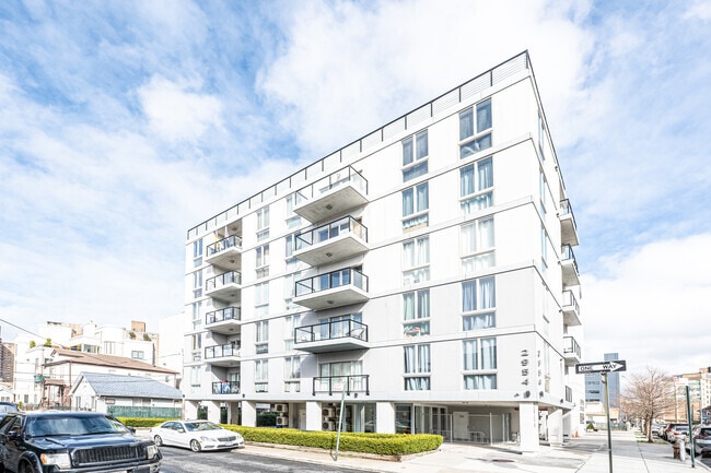

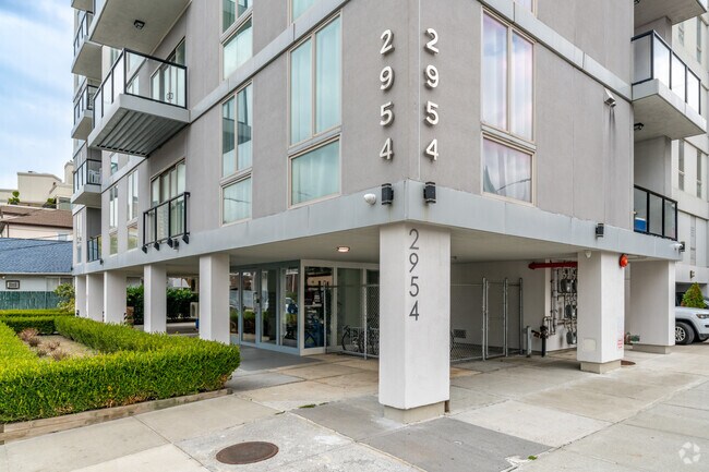

This Property Is For Sale
NEARBY LISTINGS FOR SALE OR LEASE
Property Detail
2954 Brighton 3Rd St
08662-0133
DOCID-2013110601786001
Cooperative
Kings
AE
New York
3604970354F
133
2024
0.16 AC
2025
Brighton Beach
036400
Long Island (New York)
16,006 SF
New York-Jersey City-White Plains, NY-NJ
DEMOGRAPHICS near 2954 Brighton 3Rd St
1 mile
3 mile
5 mile
2024 Total Population
88,392
477,807
1,084,117
2029 Population
83,476
446,935
1,006,314
Pop Growth 2024-2029
(5.56%)
(6.46%)
(7.18%)
Average Age
46
42
40
2024 Total Households
37,114
172,982
372,889
HH Growth 2024-2029
(5.78%)
(6.82%)
(7.49%)
Median Household Inc
$55,243
$59,284
$64,452
Avg Household Size
2.30
2.60
2.80
2024 Avg HH Vehicles
1.00
1.00
1.00
Median Home Value
$594,308
$754,382
$783,816
Median Year Built
1960
1949
1948
Nearby Places
Map Layers
Map Styles
 Street
 Aerial
Transit
 Traffic
 Biking
Places
Listings with unknown addresses are not visible on the map
- Restaurants
- Banks
- Shops
- Fitness
- Groceries
PUBLIC TRANSPORTATION
TRANSIT/SUBWAY
Brighton Beach (B - New York MTA Subway (The Subway), Q - New York MTA Subway (The Subway))
Drive
Walk
Distance
Brighton Beach (B - New York MTA Subway (The Subway), Q - New York MTA Subway (The Subway))
2 min
7 min
0.3 mi
Ocean Parkway (Q - New York MTA Subway (The Subway))
Drive
Walk
Distance
Ocean Parkway (Q - New York MTA Subway (The Subway))
2 min
7 min
0.4 mi
Neptune Avenue (F - New York MTA Subway (The Subway))
Drive
Walk
Distance
Neptune Avenue (F - New York MTA Subway (The Subway))
3 min
13 min
0.7 mi
West 8 Street-New York Aquarium (F - New York MTA Subway (The Subway), Q - New York MTA Subway (The Subway))
Drive
Walk
Distance
West 8 Street-New York Aquarium (F - New York MTA Subway (The Subway), Q - New York MTA Subway (The Subway))
4 min
19 min
0.8 mi
Coney Island-Stillwell Avenue (D - New York MTA Subway (The Subway), F - New York MTA Subway (The Subway), N - New York MTA Subway (The Subway), Q - New York MTA Subway (The Subway))
Drive
Walk
Distance
Coney Island-Stillwell Avenue (D - New York MTA Subway (The Subway), F - New York MTA Subway (The Subway), N - New York MTA Subway (The Subway), Q - New York MTA Subway (The Subway))
4 min
20 min
1.0 mi
COMMUTER RAIL
Nostrand Avenue Station (Far Rockaway Branch - Long Island Rail Road, Hempstead Branch - Long Island Rail Road, Long Beach Branch - Long Island Rail Road, West Hempstead Branch - Long Island Rail Road)
Drive
Walk
Distance
Nostrand Avenue Station (Far Rockaway Branch - Long Island Rail Road, Hempstead Branch - Long Island Rail Road, Long Beach Branch - Long Island Rail Road, West Hempstead Branch - Long Island Rail Road)
20 min
8.2 mi
Grasmere (Staten Island Railway - New York MTA Subway (The Subway))
Drive
Walk
Distance
Grasmere (Staten Island Railway - New York MTA Subway (The Subway))
18 min
8.8 mi
AIRPORT
John F Kennedy International
Drive
Walk
Distance
John F Kennedy International
25 min
14.9 mi
LaGuardia
Drive
Walk
Distance
LaGuardia
36 min
22.1 mi
Newark Liberty International
Drive
Walk
Distance
Newark Liberty International
39 min
24.0 mi
Freight Ports
NY - Red Hook Container Terminal
Drive
Walk
Distance
NY - Red Hook Container Terminal
18 min
8.5 mi
Nearby Properties
Address
Land Use
TOTAL SIZE
Lot Size
Zoning
Address
Land Use
TOTAL SIZE
Lot Size
Zoning
200 SF
281.30 AC
R4
Address
Land Use
TOTAL SIZE
Lot Size
Zoning
200 SF
281.30 AC
R4
Address
Land Use
TOTAL SIZE
Lot Size
Zoning
200 SF
281.30 AC
R4
Address
Land Use
TOTAL SIZE
Lot Size
Zoning
200 SF
281.30 AC
R4
Address
Land Use
TOTAL SIZE
Lot Size
Zoning
200 SF
281.30 AC
R4
Address
Land Use
TOTAL SIZE
Lot Size
Zoning
200 SF
281.30 AC
R4
Address
Land Use
TOTAL SIZE
Lot Size
Zoning
200 SF
281.30 AC
R4
Address
Land Use
TOTAL SIZE
Lot Size
Zoning
200 SF
281.30 AC
R4
Address
Land Use
TOTAL SIZE
Lot Size
Zoning
200 SF
281.30 AC
R4
Address
Land Use
TOTAL SIZE
Lot Size
Zoning
200 SF
281.30 AC
R4
Address
Land Use
TOTAL SIZE
Lot Size
Zoning
200 SF
281.30 AC
R4
Address
Land Use
TOTAL SIZE
Lot Size
Zoning
200 SF
281.30 AC
R4
Address
Land Use
TOTAL SIZE
Lot Size
Zoning
200 SF
281.30 AC
R4
Address
Land Use
TOTAL SIZE
Lot Size
Zoning
200 SF
281.30 AC
R4
Address
Land Use
TOTAL SIZE
Lot Size
Zoning
200 SF
281.30 AC
R4
Address
Land Use
TOTAL SIZE
Lot Size
Zoning
200 SF
281.30 AC
R4
Address
Land Use
TOTAL SIZE
Lot Size
Zoning
200 SF
281.30 AC
R4
Address
Land Use
TOTAL SIZE
Lot Size
Zoning
200 SF
281.30 AC
R4
Address
Land Use
TOTAL SIZE
Lot Size
Zoning
200 SF
281.30 AC
R4
Address
Land Use
TOTAL SIZE
Lot Size
Zoning
200 SF
281.30 AC
R4
Address
Land Use
TOTAL SIZE
Lot Size
Zoning
200 SF
281.30 AC
R4
Address
Land Use
TOTAL SIZE
Lot Size
Zoning
200 SF
281.30 AC
R4
Address
Land Use
TOTAL SIZE
Lot Size
Zoning
200 SF
281.30 AC
R4
Address
Land Use
TOTAL SIZE
Lot Size
Zoning
200 SF
281.30 AC
R4
Address
Land Use
TOTAL SIZE
Lot Size
Zoning
200 SF
281.30 AC
R4
Address
Land Use
TOTAL SIZE
Lot Size
Zoning
200 SF
281.30 AC
R4
Address
Land Use
TOTAL SIZE
Lot Size
Zoning
200 SF
281.30 AC
R4
Address
Land Use
TOTAL SIZE
Lot Size
Zoning
200 SF
281.30 AC
R4
Address
Land Use
TOTAL SIZE
Lot Size
Zoning
200 SF
281.30 AC
R4
Address
Land Use
TOTAL SIZE
Lot Size
Zoning
200 SF
281.30 AC
R4
The World's #1 Commercial Real Estate Marketplace
Connect with us
© 2026 CoStar Group
The information above has been obtained from sources believed reliable. While we do not doubt its accuracy we have not verified it and make no guarantee, warranty or representation about it. It is your responsibility to independently confirm its accuracy and completeness. Any projections, opinions, assumptions, or estimates used are for example only and do not represent the current or future performance of the property. The value of this transaction to you depends on tax and other factors which should be evaluated by your tax, financial, and legal advisors. You and your advisors should conduct a careful, independent investigation of the property to determine to your satisfaction the suitability of the property for your needs.