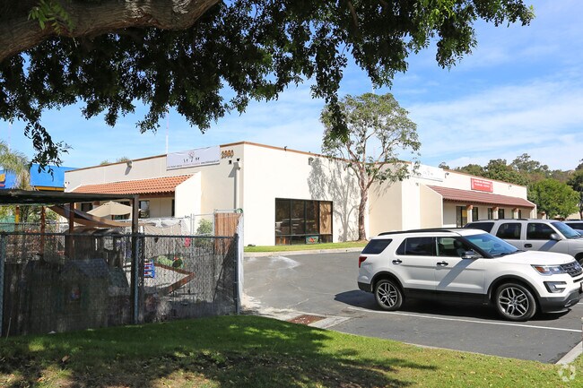
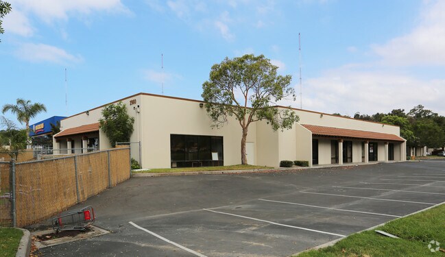
Property Record
2960 Oceanside Blvd, Oceanside, CA 92054

Property Detail
2960 Oceanside Blvd
162-030-66
PAR 2 (EX ST) TR PM11078
Storesoffices
San Diego
CG
California
AE The base floodplain where base flood elevations are provided. AE Zones are now used on new format FIRMs instead of A1-A30 Zones.
1.22 AC
2024
Oceanside
2025
San Diego
018511
San Diego-Chula Vista-Carlsbad, CA
20,166 SF
NEARBY LISTINGS FOR SALE OR LEASE
DEMOGRAPHICS near 2960 Oceanside Blvd
1 mile
3 mile
5 mile
2025 Total Population
13,022
127,798
248,711
2030 Population
13,274
129,148
250,447
Pop Growth 2025-2030
+ 1.94%
+ 1.06%
+ 0.70%
Average Age
41
40
40
2025 Total Households
4,855
47,718
88,517
HH Growth 2025-2030
+ 1.65%
+ 1.22%
+ 0.80%
Median Household Inc
$78,868
$91,182
$96,924
Avg Household Size
2.60
2.50
2.60
2025 Avg HH Vehicles
2.00
2.00
2.00
Median Home Value
$809,017
$790,602
$799,580
Median Year Built
1978
1981
1983
Nearby Places
Map Layers
Map Styles
 Street
 Aerial
Layers
 Traffic
 Biking
Places
Listings with unknown addresses are not visible on the map
- Restaurants
- Banks
- Shops
- Fitness
- Groceries
PUBLIC TRANSPORTATION
TRANSIT/SUBWAY
El Camino Real (Sprinter - San Diego North County Transit District (Coaster/Sprinter/Breeze))
Drive
Walk
Distance
El Camino Real (Sprinter - San Diego North County Transit District (Coaster/Sprinter/Breeze))
2 min
10 min
0.5 mi
COMMUTER RAIL
Oceanside Transit Center (Metrolink Inland Empire-Orange County Line - Metrolink Trains, Metrolink Orange County Line - Metrolink Trains, Orange County Line - Metrolink Trains)
Drive
Walk
Distance
Oceanside Transit Center (Metrolink Inland Empire-Orange County Line - Metrolink Trains, Metrolink Orange County Line - Metrolink Trains, Orange County Line - Metrolink Trains)
8 min
3.6 mi
Carlsbad Village (Coaster - San Diego North County Transit District (Coaster/Sprinter/Breeze))
Drive
Walk
Distance
Carlsbad Village (Coaster - San Diego North County Transit District (Coaster/Sprinter/Breeze))
10 min
4.8 mi
Freight Ports
Port of San Diego
Drive
Walk
Distance
Port of San Diego
53 min
41.1 mi
Nearby Properties
Address
Land Use
TOTAL SIZE
Lot Size
Zoning
Address
Land Use
TOTAL SIZE
Lot Size
Zoning
20.96 AC
SP-1-84 (I
Address
Land Use
TOTAL SIZE
Lot Size
Zoning
1.38 AC
C
Address
Land Use
TOTAL SIZE
Lot Size
Zoning
15.74 AC
SP-1-84 (I
Address
Land Use
TOTAL SIZE
Lot Size
Zoning
15.25 AC
P-C
Address
Land Use
TOTAL SIZE
Lot Size
Zoning
9,999 SF
5.28 AC
C2
Address
Land Use
TOTAL SIZE
Lot Size
Zoning
31.94 AC
RM-B
Address
Land Use
TOTAL SIZE
Lot Size
Zoning
16 AC
P-C
Address
Land Use
TOTAL SIZE
Lot Size
Zoning
38.61 AC
PD-1 (IL)
Address
Land Use
TOTAL SIZE
Lot Size
Zoning
1.38 AC
C
Address
Land Use
TOTAL SIZE
Lot Size
Zoning
9.22 AC
RH
Address
Land Use
TOTAL SIZE
Lot Size
Zoning
12 AC
SP-1-09
Address
Land Use
TOTAL SIZE
Lot Size
Zoning
4.26 AC
C-2
Address
Land Use
TOTAL SIZE
Lot Size
Zoning
1.77 AC
C-2
Address
Land Use
TOTAL SIZE
Lot Size
Zoning
1.14 AC
C
Address
Land Use
TOTAL SIZE
Lot Size
Zoning
8.01 AC
PD-19-H
Address
Land Use
TOTAL SIZE
Lot Size
Zoning
96,240 SF
22.25 AC
PD-2
Address
Land Use
TOTAL SIZE
Lot Size
Zoning
85,000 SF
4.40 AC
CC
Address
Land Use
TOTAL SIZE
Lot Size
Zoning
5.24 AC
SP-1-09
Address
Land Use
TOTAL SIZE
Lot Size
Zoning
19.51 AC
C-2-Q
Address
Land Use
TOTAL SIZE
Lot Size
Zoning
10.63 AC
RD-M
Address
Land Use
TOTAL SIZE
Lot Size
Zoning
1.02 AC
D-1
Address
Land Use
TOTAL SIZE
Lot Size
Zoning
4.68 AC
D-6B
Address
Land Use
TOTAL SIZE
Lot Size
Zoning
15.02 AC
SP-1-84 (I
Address
Land Use
TOTAL SIZE
Lot Size
Zoning
25.16 AC
SP-1-84 (I
Address
Land Use
TOTAL SIZE
Lot Size
Zoning
87,472 SF
4.96 AC
RM-A
Address
Land Use
TOTAL SIZE
Lot Size
Zoning
65,156 SF
2.52 AC
PD-1 (IL)
Address
Land Use
TOTAL SIZE
Lot Size
Zoning
11.60 AC
RM-C
Address
Land Use
TOTAL SIZE
Lot Size
Zoning
10,500 SF
43.77 AC
RM-A-SMH
Address
Land Use
TOTAL SIZE
Lot Size
Zoning
6.63 AC
RD-M
Address
Land Use
TOTAL SIZE
Lot Size
Zoning
78,489 SF
2.67 AC
PD-1 (IL)
The World's #1 Commercial Real Estate Marketplace
Connect with us
© 2026 CoStar Group
The information above has been obtained from sources believed reliable. While we do not doubt its accuracy we have not verified it and make no guarantee, warranty or representation about it. It is your responsibility to independently confirm its accuracy and completeness. Any projections, opinions, assumptions, or estimates used are for example only and do not represent the current or future performance of the property. The value of this transaction to you depends on tax and other factors which should be evaluated by your tax, financial, and legal advisors. You and your advisors should conduct a careful, independent investigation of the property to determine to your satisfaction the suitability of the property for your needs.