Property Record
2985 Xavier Ray Ct, Snellville, GA 30039
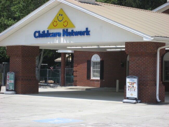

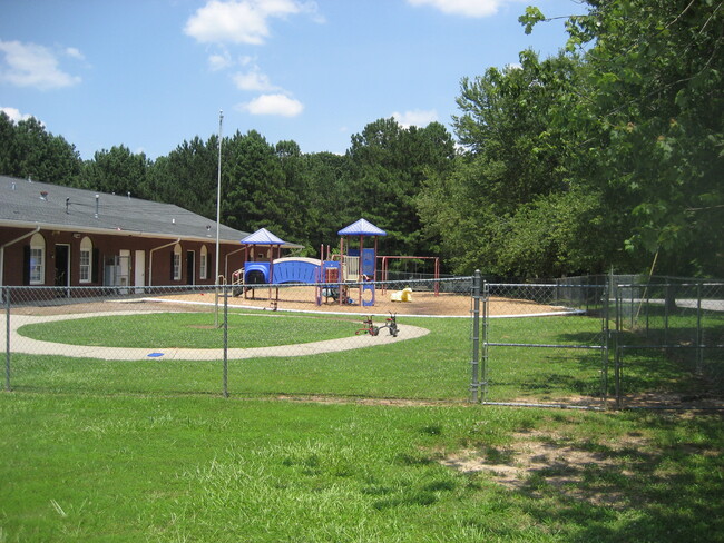
Property Detail
2985 Xavier Ray Ct
5-002-151
LENORA CHURCH RD
Daycare
GWINNETT
C1
Georgia
B and X Area of moderate flood hazard, usually the area between the limits of the 100-year and 500-year floods.
2
2025
2 AC
2025
Lilburn/Snellville
050739
Atlanta
10,560 SF
Atlanta-Sandy Springs-Roswell, GA
NEARBY LISTINGS FOR SALE OR LEASE
DEMOGRAPHICS near 2985 Xavier Ray Ct
1 mile
3 mile
5 mile
2024 Total Population
5,349
52,717
125,427
2029 Population
5,575
54,545
130,552
Pop Growth 2024-2029
+ 4.23%
+ 3.47%
+ 4.09%
Average Age
40
38
38
2024 Total Households
1,725
16,840
40,706
HH Growth 2024-2029
+ 4.35%
+ 3.56%
+ 4.18%
Median Household Inc
$99,599
$81,260
$81,957
Avg Household Size
3.10
3.10
3.00
2024 Avg HH Vehicles
3.00
2.00
2.00
Median Home Value
$401,266
$260,513
$266,120
Median Year Built
1998
1992
1991
Nearby Places
Map Layers
Map Styles
 Street
 Aerial
Transit
 Traffic
 Biking
Places
Listings with unknown addresses are not visible on the map
- Restaurants
- Banks
- Shops
- Fitness
- Groceries
PUBLIC TRANSPORTATION
AIRPORT
Hartsfield - Jackson Atlanta International
Drive
Walk
Distance
Hartsfield - Jackson Atlanta International
53 min
34.0 mi
SALE & LEASE HISTORY
LISTING DATE
SALE/LEASE

Jun 28, 2025
For Sale
Nearby Properties
Address
Land Use
TOTAL SIZE
Lot Size
Zoning
Address
Land Use
TOTAL SIZE
Lot Size
Zoning
469,566 SF
24.30 AC
RS180
Address
Land Use
TOTAL SIZE
Lot Size
Zoning
162,474 SF
41 AC
R100
Address
Land Use
TOTAL SIZE
Lot Size
Zoning
175,045 SF
13.01 AC
RM
Address
Land Use
TOTAL SIZE
Lot Size
Zoning
23,692 SF
112.46 AC
RA200
Address
Land Use
TOTAL SIZE
Lot Size
Zoning
196,333 SF
23.27 AC
RS180
Address
Land Use
TOTAL SIZE
Lot Size
Zoning
217,730 SF
29.68 AC
C2
Address
Land Use
TOTAL SIZE
Lot Size
Zoning
79,339 SF
38.25 AC
RS180
Address
Land Use
TOTAL SIZE
Lot Size
Zoning
100,427 SF
22.60 AC
RA200
Address
Land Use
TOTAL SIZE
Lot Size
Zoning
103,821 SF
10.80 AC
M1
Address
Land Use
TOTAL SIZE
Lot Size
Zoning
151,922 SF
18.19 AC
R100
Address
Land Use
TOTAL SIZE
Lot Size
Zoning
91,096 SF
28.67 AC
OI
Address
Land Use
TOTAL SIZE
Lot Size
Zoning
90,000 SF
9.32 AC
M1
Address
Land Use
TOTAL SIZE
Lot Size
Zoning
90,151 SF
2.38 AC
C2
Address
Land Use
TOTAL SIZE
Lot Size
Zoning
57,206 SF
7 AC
C2
Address
Land Use
TOTAL SIZE
Lot Size
Zoning
75,930 SF
2.31 AC
HSB
Address
Land Use
TOTAL SIZE
Lot Size
Zoning
68,800 SF
9.01 AC
C2
Address
Land Use
TOTAL SIZE
Lot Size
Zoning
1,296 SF
65.93 AC
R100
Address
Land Use
TOTAL SIZE
Lot Size
Zoning
3,403 SF
34.69 AC
CI
Address
Land Use
TOTAL SIZE
Lot Size
Zoning
42,183 SF
11.87 AC
C2
Address
Land Use
TOTAL SIZE
Lot Size
Zoning
93,914 SF
1.56 AC
C2
Address
Land Use
TOTAL SIZE
Lot Size
Zoning
88,464 SF
8.86 AC
RM
Address
Land Use
TOTAL SIZE
Lot Size
Zoning
18,420 SF
13.92 AC
OI
Address
Land Use
TOTAL SIZE
Lot Size
Zoning
26,866 SF
8.21 AC
OI
Address
Land Use
TOTAL SIZE
Lot Size
Zoning
8,976 SF
23.21 AC
CI
Address
Land Use
TOTAL SIZE
Lot Size
Zoning
30,158 SF
17.25 AC
RS180
Address
Land Use
TOTAL SIZE
Lot Size
Zoning
36.74 AC
R100
Address
Land Use
TOTAL SIZE
Lot Size
Zoning
38,237 SF
5.86 AC
R100
Address
Land Use
TOTAL SIZE
Lot Size
Zoning
116,970 SF
19.90 AC
C2
Address
Land Use
TOTAL SIZE
Lot Size
Zoning
36,320 SF
15.43 AC
R100
Address
Land Use
TOTAL SIZE
Lot Size
Zoning
31,434 SF
3.23 AC
C2
The World's #1 Commercial Real Estate Marketplace
Connect with us
© 2026 CoStar Group
The information above has been obtained from sources believed reliable. While we do not doubt its accuracy we have not verified it and make no guarantee, warranty or representation about it. It is your responsibility to independently confirm its accuracy and completeness. Any projections, opinions, assumptions, or estimates used are for example only and do not represent the current or future performance of the property. The value of this transaction to you depends on tax and other factors which should be evaluated by your tax, financial, and legal advisors. You and your advisors should conduct a careful, independent investigation of the property to determine to your satisfaction the suitability of the property for your needs.