Property Record
2Nd St, Port Isabel, TX 78578


Property Detail
2Nd St
Brownsville-Harlingen, TX
LOT 2 CACTUS COVE SUBDIVISION (2012 REPLAT C1-3071 A CCMR FILED 7/13/11) (2012 C1-3061 A CCMR FILED 3/30/11)
472802-0000-002000
CAMERON
Commercialacreage
Texas
AE The base floodplain where base flood elevations are provided. AE Zones are now used on new format FIRMs instead of A1-A30 Zones.
2
2024
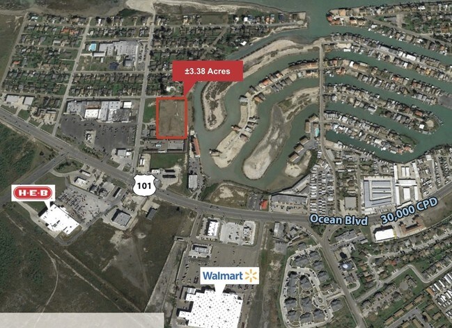
3.39 AC
2025
Outlying Cameron County
012304
Brownsville/Harlingen
NEARBY LISTINGS FOR SALE OR LEASE
DEMOGRAPHICS near 2Nd St
1 mile
3 mile
5 mile
2025 Total Population
3,080
6,573
11,264
2030 Population
3,019
6,628
11,717
Pop Growth 2025-2030
(1.98%)
+ 0.84%
+ 4.02%
Average Age
41
43
46
2025 Total Households
1,157
2,576
4,668
HH Growth 2025-2030
(1.56%)
+ 2.14%
+ 5.21%
Median Household Inc
$52,630
$55,587
$58,446
Avg Household Size
2.60
2.50
2.40
2025 Avg HH Vehicles
1.00
1.00
2.00
Median Home Value
$241,025
$291,093
$358,579
Median Year Built
1982
1985
1986
Nearby Places
Map Layers
Map Styles
 Street
 Aerial
Layers
 Traffic
 Biking
Places
Listings with unknown addresses are not visible on the map
- Restaurants
- Banks
- Shops
- Fitness
- Groceries
PUBLIC TRANSPORTATION
AIRPORT
Brownsville/South Padre Island International
Drive
Walk
Distance
Brownsville/South Padre Island International
25 min
19.6 mi
Valley International
Drive
Walk
Distance
Valley International
51 min
42.5 mi
Freight Ports
Port of Brownsville
Drive
Walk
Distance
Port of Brownsville
18 min
15.8 mi
SALE & LEASE HISTORY
LISTING DATE
SALE/LEASE

Jan 11, 2017
For Sale
Feb 23, 2017
For Sale
Nearby Properties
Address
Land Use
TOTAL SIZE
Lot Size
Zoning
Address
Land Use
TOTAL SIZE
Lot Size
Zoning
194,092 SF
40 AC
C
Address
Land Use
TOTAL SIZE
Lot Size
Zoning
90,794 SF
22.76 AC
C
Address
Land Use
TOTAL SIZE
Lot Size
Zoning
159,538 SF
22.34 AC
Address
Land Use
TOTAL SIZE
Lot Size
Zoning
83,500 SF
4.80 AC
A-C
Address
Land Use
TOTAL SIZE
Lot Size
Zoning
15,193 SF
15.34 AC
M-R
Address
Land Use
TOTAL SIZE
Lot Size
Zoning
78,345 SF
7.05 AC
A-C
Address
Land Use
TOTAL SIZE
Lot Size
Zoning
Address
Land Use
TOTAL SIZE
Lot Size
Zoning
62,486 SF
9.83 AC
C
Address
Land Use
TOTAL SIZE
Lot Size
Zoning
92,749 SF
8.58 AC
Address
Land Use
TOTAL SIZE
Lot Size
Zoning
48,150 SF
3.14 AC
C
Address
Land Use
TOTAL SIZE
Lot Size
Zoning
9,093 SF
0.83 AC
C
Address
Land Use
TOTAL SIZE
Lot Size
Zoning
78,361 SF
9.60 AC
B
Address
Land Use
TOTAL SIZE
Lot Size
Zoning
106,404 SF
7.25 AC
Address
Land Use
TOTAL SIZE
Lot Size
Zoning
70,789 SF
Address
Land Use
TOTAL SIZE
Lot Size
Zoning
60,083 SF
10.84 AC
C
Address
Land Use
TOTAL SIZE
Lot Size
Zoning
45,591 SF
3.36 AC
Address
Land Use
TOTAL SIZE
Lot Size
Zoning
48,596 SF
4.73 AC
C
Address
Land Use
TOTAL SIZE
Lot Size
Zoning
17,616 SF
1.13 AC
C
Address
Land Use
TOTAL SIZE
Lot Size
Zoning
5,514 SF
0.35 AC
A-C
Address
Land Use
TOTAL SIZE
Lot Size
Zoning
14,991 SF
1.37 AC
Address
Land Use
TOTAL SIZE
Lot Size
Zoning
21,756 SF
2.48 AC
Address
Land Use
TOTAL SIZE
Lot Size
Zoning
6,329 SF
1.35 AC
Address
Land Use
TOTAL SIZE
Lot Size
Zoning
17,352 SF
0.28 AC
Address
Land Use
TOTAL SIZE
Lot Size
Zoning
25,996 SF
1.65 AC
C
Address
Land Use
TOTAL SIZE
Lot Size
Zoning
25,257 SF
2.72 AC
C
Address
Land Use
TOTAL SIZE
Lot Size
Zoning
41,639 SF
1.68 AC
AC
Address
Land Use
TOTAL SIZE
Lot Size
Zoning
11,100 SF
0.94 AC
Address
Land Use
TOTAL SIZE
Lot Size
Zoning
16,700 SF
2.12 AC
Address
Land Use
TOTAL SIZE
Lot Size
Zoning
10,143 SF
0.57 AC
C
Address
Land Use
TOTAL SIZE
Lot Size
Zoning
2,356 SF
1.82 AC
The World's #1 Commercial Real Estate Marketplace
Connect with us
© 2026 CoStar Group
The information above has been obtained from sources believed reliable. While we do not doubt its accuracy we have not verified it and make no guarantee, warranty or representation about it. It is your responsibility to independently confirm its accuracy and completeness. Any projections, opinions, assumptions, or estimates used are for example only and do not represent the current or future performance of the property. The value of this transaction to you depends on tax and other factors which should be evaluated by your tax, financial, and legal advisors. You and your advisors should conduct a careful, independent investigation of the property to determine to your satisfaction the suitability of the property for your needs.