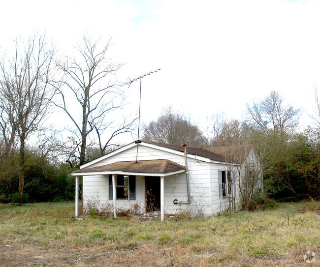
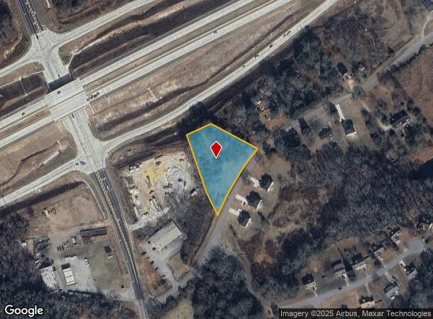
Property Record
30 Gifton Thomas Rd, Bethlehem, GA 30620

NEARBY LISTINGS FOR SALE OR LEASE
Property Detail
30 Gifton Thomas Rd
BE05-025
Turtle Creek Villas Phase Ii
Residentialacreage
30 GIFTON THOMAS RD
X
Barrow
13013C0129D
Georgia
2024
1.40 AC
2024
Barrow County
180502
Atlanta
1,578 SF
Atlanta-Sandy Springs-Roswell, GA
DEMOGRAPHICS near 30 Gifton Thomas Rd
1 Mile
3 Mile
5 Mile
2024 Total Population
871
12,961
47,574
2029 Population
1,015
15,140
55,668
Pop Growth 2024-2029
+ 16.53%
+ 16.81%
+ 17.01%
Average Age
38
36
37
2024 Total Households
299
4,263
16,358
HH Growth 2024-2029
+ 16.39%
+ 16.96%
+ 17.17%
Median Household Inc
$55,416
$62,818
$63,469
Avg Household Size
2.90
2.90
2.80
2024 Avg HH Vehicles
3.00
2.00
2.00
Median Home Value
$214,286
$216,570
$211,772
Median Year Built
1994
1999
2000
Nearby Places
Map Layers
Map Styles
 Street
 Aerial
- Restaurants
- Banks
- Shops
- Fitness
- Groceries
SALE & LEASE HISTORY
LISTING DATE
SALE/LEASE

Sep 26, 2022
For Sale
Nearby Properties
Address
Land Use
TOTAL SIZE
Lot Size
Zoning
Address
Land Use
TOTAL SIZE
Lot Size
Zoning
1,456 SF
1,732.80 AC
G
Address
Land Use
TOTAL SIZE
Lot Size
Zoning
26,789 SF
35.60 AC
C-3
Address
Land Use
TOTAL SIZE
Lot Size
Zoning
2,046 SF
13 AC
B-2,R-3
Address
Land Use
TOTAL SIZE
Lot Size
Zoning
132,156 SF
10.10 AC
C-2
Address
Land Use
TOTAL SIZE
Lot Size
Zoning
79,029 SF
9.70 AC
C-2
Address
Land Use
TOTAL SIZE
Lot Size
Zoning
37,162 SF
4.60 AC
R-3
Address
Land Use
TOTAL SIZE
Lot Size
Zoning
104,805 SF
12.50 AC
C-3
Address
Land Use
TOTAL SIZE
Lot Size
Zoning
3,370 SF
352.40 AC
G,TNPD
Address
Land Use
TOTAL SIZE
Lot Size
Zoning
55,420 SF
5 AC
C-3
Address
Land Use
TOTAL SIZE
Lot Size
Zoning
26,802 SF
5 AC
AG
Address
Land Use
TOTAL SIZE
Lot Size
Zoning
20,857 SF
39.60 AC
M-1
Address
Land Use
TOTAL SIZE
Lot Size
Zoning
24,982 SF
16.10 AC
R-1
Address
Land Use
TOTAL SIZE
Lot Size
Zoning
46,339 SF
2 AC
B-2
Address
Land Use
TOTAL SIZE
Lot Size
Zoning
20,592 SF
66.10 AC
G
Address
Land Use
TOTAL SIZE
Lot Size
Zoning
76,768 SF
19 AC
AG
Address
Land Use
TOTAL SIZE
Lot Size
Zoning
45,296 SF
8.20 AC
B-2
Address
Land Use
TOTAL SIZE
Lot Size
Zoning
143,025 SF
9.30 AC
M-1
Address
Land Use
TOTAL SIZE
Lot Size
Zoning
19,483 SF
2.80 AC
B-2
Address
Land Use
TOTAL SIZE
Lot Size
Zoning
11,914 SF
6.90 AC
G,R-2,R-3
Address
Land Use
TOTAL SIZE
Lot Size
Zoning
49,920 SF
24.50 AC
AG
Address
Land Use
TOTAL SIZE
Lot Size
Zoning
18,240 SF
0.93 AC
B-2
Address
Land Use
TOTAL SIZE
Lot Size
Zoning
38,423 SF
4.10 AC
R-1
Address
Land Use
TOTAL SIZE
Lot Size
Zoning
5,500 SF
12.90 AC
C-3
Address
Land Use
TOTAL SIZE
Lot Size
Zoning
4,026 SF
1.60 AC
B-2
Address
Land Use
TOTAL SIZE
Lot Size
Zoning
47,130 SF
17.60 AC
M-1
Address
Land Use
TOTAL SIZE
Lot Size
Zoning
21,514 SF
0.50 AC
B-2
Address
Land Use
TOTAL SIZE
Lot Size
Zoning
14,356 SF
2.30 AC
B-2
Address
Land Use
TOTAL SIZE
Lot Size
Zoning
1,395 SF
0.16 AC
HPM2*
Address
Land Use
TOTAL SIZE
Lot Size
Zoning
93,611 SF
9.90 AC
I
Address
Land Use
TOTAL SIZE
Lot Size
Zoning
13,439 SF
1.30 AC
B-2
The World's #1 Commercial Real Estate Marketplace
Connect with us
© 2025 CoStar Group
The information above has been obtained from sources believed reliable. While we do not doubt its accuracy we have not verified it and make no guarantee, warranty or representation about it. It is your responsibility to independently confirm its accuracy and completeness. Any projections, opinions, assumptions, or estimates used are for example only and do not represent the current or future performance of the property. The value of this transaction to you depends on tax and other factors which should be evaluated by your tax, financial, and legal advisors. You and your advisors should conduct a careful, independent investigation of the property to determine to your satisfaction the suitability of the property for your needs.