Property Record
300 Palm Dr, Corpus Christi, TX 78408
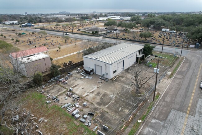
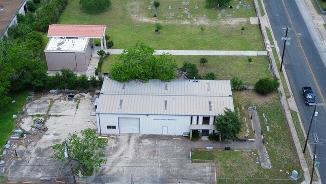
Property Detail
300 Palm Dr
Corpus Christi, TX
HAWN TRACT S127.95 OF LT 2 TR L
242336
NUECES
Industrialacreage
Texas
I-3
2
B and X Area of moderate flood hazard, usually the area between the limits of the 100-year and 500-year floods.
0.28 AC
2024
West Side
2025
Corpus Christi
001100
NEARBY LISTINGS FOR SALE OR LEASE
DEMOGRAPHICS near 300 Palm Dr
1 mile
3 mile
5 mile
2025 Total Population
11,633
56,234
103,646
2030 Population
11,784
56,208
102,890
Pop Growth 2025-2030
+ 1.30%
(0.05%)
(0.73%)
Average Age
39
40
40
2025 Total Households
3,971
20,273
37,535
HH Growth 2025-2030
+ 1.36%
+ 0.06%
(0.65%)
Median Household Inc
$37,500
$42,792
$49,746
Avg Household Size
2.60
2.60
2.60
2025 Avg HH Vehicles
1.00
2.00
2.00
Median Home Value
$67,548
$96,117
$124,034
Median Year Built
1960
1958
1958
Nearby Places
Map Layers
Map Styles
 Street
 Aerial
Layers
 Traffic
 Biking
Places
Listings with unknown addresses are not visible on the map
- Restaurants
- Banks
- Shops
- Fitness
- Groceries
PUBLIC TRANSPORTATION
AIRPORT
Corpus Christi International
Drive
Walk
Distance
Corpus Christi International
13 min
6.6 mi
Freight Ports
Port of Corpus Christi
Drive
Walk
Distance
Port of Corpus Christi
6 min
3.1 mi
SALE & LEASE HISTORY
LISTING DATE
SALE/LEASE

Mar 25, 2025
For Sale
Nearby Properties
Address
Land Use
TOTAL SIZE
Lot Size
Zoning
Address
Land Use
TOTAL SIZE
Lot Size
Zoning
382,448 SF
14.98 AC
Address
Land Use
TOTAL SIZE
Lot Size
Zoning
674,927 SF
10.54 AC
B4
Address
Land Use
TOTAL SIZE
Lot Size
Zoning
594,377 SF
29.96 AC
B5
Address
Land Use
TOTAL SIZE
Lot Size
Zoning
1 SF
62.73 AC
III
Address
Land Use
TOTAL SIZE
Lot Size
Zoning
24,217 SF
4.39 AC
B2
Address
Land Use
TOTAL SIZE
Lot Size
Zoning
370,000 SF
1.47 AC
B-2
Address
Land Use
TOTAL SIZE
Lot Size
Zoning
15.10 AC
I3
Address
Land Use
TOTAL SIZE
Lot Size
Zoning
1 SF
13.71 AC
B5
Address
Land Use
TOTAL SIZE
Lot Size
Zoning
302,344 SF
5 AC
Address
Land Use
TOTAL SIZE
Lot Size
Zoning
392,617 SF
2.20 AC
B2
Address
Land Use
TOTAL SIZE
Lot Size
Zoning
131,533 SF
23.24 AC
I3
Address
Land Use
TOTAL SIZE
Lot Size
Zoning
1 SF
10.53 AC
I2
Address
Land Use
TOTAL SIZE
Lot Size
Zoning
10,000 SF
35.96 AC
R1B
Address
Land Use
TOTAL SIZE
Lot Size
Zoning
72,106 SF
1.96 AC
B-5
Address
Land Use
TOTAL SIZE
Lot Size
Zoning
11.03 AC
I3
Address
Land Use
TOTAL SIZE
Lot Size
Zoning
75,120 SF
1.93 AC
B2
Address
Land Use
TOTAL SIZE
Lot Size
Zoning
85,871 SF
18.68 AC
R1B
Address
Land Use
TOTAL SIZE
Lot Size
Zoning
11,109 SF
76.58 AC
R1B
Address
Land Use
TOTAL SIZE
Lot Size
Zoning
177,545 SF
7.75 AC
B2
Address
Land Use
TOTAL SIZE
Lot Size
Zoning
52,121 SF
27.73 AC
Address
Land Use
TOTAL SIZE
Lot Size
Zoning
74,261 SF
4.44 AC
R1B
Address
Land Use
TOTAL SIZE
Lot Size
Zoning
361,000 SF
2.20 AC
B6PUD2
Address
Land Use
TOTAL SIZE
Lot Size
Zoning
105.49 AC
R1B
Address
Land Use
TOTAL SIZE
Lot Size
Zoning
103,628 SF
2.61 AC
Address
Land Use
TOTAL SIZE
Lot Size
Zoning
145,296 SF
1.21 AC
B6
Address
Land Use
TOTAL SIZE
Lot Size
Zoning
94,600 SF
9.29 AC
R2
Address
Land Use
TOTAL SIZE
Lot Size
Zoning
129,210 SF
11.63 AC
R1B
Address
Land Use
TOTAL SIZE
Lot Size
Zoning
315,038 SF
1.38 AC
B-6
Address
Land Use
TOTAL SIZE
Lot Size
Zoning
73,595 SF
2.63 AC
B5
Address
Land Use
TOTAL SIZE
Lot Size
Zoning
218,757 SF
2.20 AC
B2
The World's #1 Commercial Real Estate Marketplace
Connect with us
© 2026 CoStar Group
The information above has been obtained from sources believed reliable. While we do not doubt its accuracy we have not verified it and make no guarantee, warranty or representation about it. It is your responsibility to independently confirm its accuracy and completeness. Any projections, opinions, assumptions, or estimates used are for example only and do not represent the current or future performance of the property. The value of this transaction to you depends on tax and other factors which should be evaluated by your tax, financial, and legal advisors. You and your advisors should conduct a careful, independent investigation of the property to determine to your satisfaction the suitability of the property for your needs.