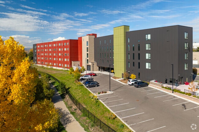
Property Record
300 W Lehow Ave, Englewood, CO 80110


NEARBY LISTINGS FOR SALE OR LEASE
Property Detail
300 W Lehow Ave
Denver
Rafferty Gardens Amendment No 1
Denver-Aurora-Centennial, CO
TOWNSHIP T5S MAPPLATB E208 MAPPLATP 4826 SUBDIVISIONCD 050901 SUBDIVISIONNAME RAFFERTY GARDENS AMENDMENT NO 1 LOT 001 LOT 1 RAFFERTY GARDENS AMENDMENT #1
2077-15-2-31-001
Arapahoe
Apartment
Colorado
2024
1
2025
4.17 AC
006601
Englewood
98,523 SF
DEMOGRAPHICS near 300 W Lehow Ave
1 Mile
3 Mile
5 Mile
2024 Total Population
16,822
97,275
288,465
2029 Population
17,038
97,715
291,780
Pop Growth 2024-2029
+ 1.28%
+ 0.45%
+ 1.15%
Average Age
39
42
41
2024 Total Households
7,367
42,386
121,557
HH Growth 2024-2029
+ 1.45%
+ 0.51%
+ 1.33%
Median Household Inc
$61,317
$81,681
$93,664
Avg Household Size
2.20
2.20
2.30
2024 Avg HH Vehicles
2.00
2.00
2.00
Median Home Value
$475,463
$563,417
$625,104
Median Year Built
1964
1971
1975
Nearby Places
Map Layers
Map Styles
 Street
 Aerial
- Restaurants
- Banks
- Shops
- Fitness
- Groceries
PUBLIC TRANSPORTATION
AIRPORT
Denver International
DRIVE
WALK
Distance
Denver International
41 min
30.9 mi
Freight Ports
Tulsa Port Of Catoosa
DRIVE
WALK
Distance
Tulsa Port Of Catoosa
738 min
713.7 mi
Nearby Properties
Address
Land Use
TOTAL SIZE
Lot Size
Zoning
Address
Land Use
TOTAL SIZE
Lot Size
Zoning
117,535 SF
4.76 AC
Address
Land Use
TOTAL SIZE
Lot Size
Zoning
248,291 SF
128.77 AC
CMP-H2
Address
Land Use
TOTAL SIZE
Lot Size
Zoning
330,776 SF
48.11 AC
CMP-H2
Address
Land Use
TOTAL SIZE
Lot Size
Zoning
251,583 SF
38.03 AC
Address
Land Use
TOTAL SIZE
Lot Size
Zoning
68,500 SF
2.14 AC
Address
Land Use
TOTAL SIZE
Lot Size
Zoning
214,192 SF
0.03 AC
Address
Land Use
TOTAL SIZE
Lot Size
Zoning
206,632 SF
33.68 AC
Address
Land Use
TOTAL SIZE
Lot Size
Zoning
250,402 SF
21 AC
Address
Land Use
TOTAL SIZE
Lot Size
Zoning
14,029 SF
23.97 AC
Address
Land Use
TOTAL SIZE
Lot Size
Zoning
38,992 SF
1 AC
Address
Land Use
TOTAL SIZE
Lot Size
Zoning
42,444 SF
1.41 AC
Address
Land Use
TOTAL SIZE
Lot Size
Zoning
58,006 SF
1.80 AC
Address
Land Use
TOTAL SIZE
Lot Size
Zoning
110,016 SF
1.29 AC
Address
Land Use
TOTAL SIZE
Lot Size
Zoning
167,287 SF
13.65 AC
Address
Land Use
TOTAL SIZE
Lot Size
Zoning
221,025 SF
8.45 AC
PUD
Address
Land Use
TOTAL SIZE
Lot Size
Zoning
139,858 SF
2.36 AC
Address
Land Use
TOTAL SIZE
Lot Size
Zoning
47.24 AC
Address
Land Use
TOTAL SIZE
Lot Size
Zoning
458,000 SF
5.85 AC
Address
Land Use
TOTAL SIZE
Lot Size
Zoning
107,159 SF
26.40 AC
Address
Land Use
TOTAL SIZE
Lot Size
Zoning
118,881 SF
107.83 AC
Address
Land Use
TOTAL SIZE
Lot Size
Zoning
137,526 SF
11.35 AC
Address
Land Use
TOTAL SIZE
Lot Size
Zoning
572,657 SF
0.21 AC
LPD-C
Address
Land Use
TOTAL SIZE
Lot Size
Zoning
229,830 SF
11.33 AC
Address
Land Use
TOTAL SIZE
Lot Size
Zoning
8,502 SF
3.32 AC
Address
Land Use
TOTAL SIZE
Lot Size
Zoning
90,350 SF
11.44 AC
Address
Land Use
TOTAL SIZE
Lot Size
Zoning
39.44 AC
Address
Land Use
TOTAL SIZE
Lot Size
Zoning
63,732 SF
1.58 AC
Address
Land Use
TOTAL SIZE
Lot Size
Zoning
7,035 SF
12.90 AC
LPD-R
Address
Land Use
TOTAL SIZE
Lot Size
Zoning
133,594 SF
25.03 AC
The World's #1 Commercial Real Estate Marketplace
Connect with us
© 2026 CoStar Group
The information above has been obtained from sources believed reliable. While we do not doubt its accuracy we have not verified it and make no guarantee, warranty or representation about it. It is your responsibility to independently confirm its accuracy and completeness. Any projections, opinions, assumptions, or estimates used are for example only and do not represent the current or future performance of the property. The value of this transaction to you depends on tax and other factors which should be evaluated by your tax, financial, and legal advisors. You and your advisors should conduct a careful, independent investigation of the property to determine to your satisfaction the suitability of the property for your needs.