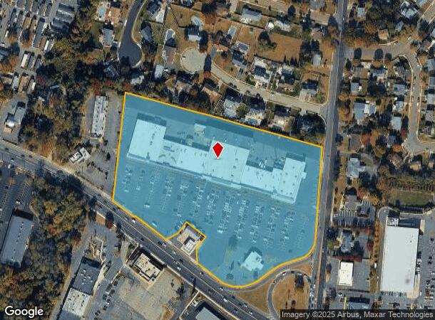
Property Record
2985 Highway 35, Hazlet, NJ 07730

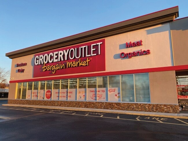

Current Lease Availabilities
NEARBY LISTINGS FOR SALE OR LEASE
Property Detail
2985 Highway 35
18-00182-0000-00006
Monmouth
Commercialnec
New Jersey
AE
6
34025C0041F
10.84 AC
2024
Eastern Monmouth
2025
Northern New Jersey
802300
New York-Jersey City-White Plains, NY-NJ
103,758 SF
DEMOGRAPHICS near 2985 Highway 35
1 Mile
3 Mile
5 Mile
2024 Total Population
10,139
69,086
139,314
2029 Population
10,041
68,625
138,291
Pop Growth 2024-2029
(0.97%)
(0.67%)
(0.73%)
Average Age
43
42
42
2024 Total Households
3,652
25,660
51,337
HH Growth 2024-2029
(1.20%)
(0.84%)
(0.91%)
Median Household Inc
$106,793
$106,822
$110,288
Avg Household Size
2.70
2.60
2.60
2024 Avg HH Vehicles
2.00
2.00
2.00
Median Home Value
$425,799
$411,056
$424,406
Median Year Built
1967
1968
1969
Nearby Places
Map Layers
Map Styles
 Street
 Aerial
- Restaurants
- Banks
- Shops
- Fitness
- Groceries
PUBLIC TRANSPORTATION
COMMUTER RAIL
Hazlet (North Jersey Coast Line - NJ Transit Commuter Rail (NJ Transit))
DRIVE
WALK
Distance
Hazlet (North Jersey Coast Line - NJ Transit Commuter Rail (NJ Transit))
3 min
1.5 mi
Aberdeen Matawan (North Jersey Coast Line - NJ Transit Commuter Rail (NJ Transit))
DRIVE
WALK
Distance
Aberdeen Matawan (North Jersey Coast Line - NJ Transit Commuter Rail (NJ Transit))
5 min
3.0 mi
AIRPORT
Newark Liberty International
DRIVE
WALK
Distance
Newark Liberty International
40 min
29.0 mi
LaGuardia
DRIVE
WALK
Distance
LaGuardia
69 min
46.3 mi
John F Kennedy International
DRIVE
WALK
Distance
John F Kennedy International
71 min
49.5 mi
Freight Ports
New York Container Terminal
DRIVE
WALK
Distance
New York Container Terminal
33 min
24.1 mi
Nearby Properties
Address
Land Use
TOTAL SIZE
Lot Size
Zoning
Address
Land Use
TOTAL SIZE
Lot Size
Zoning
836,881 SF
253 AC
R-45
Address
Land Use
TOTAL SIZE
Lot Size
Zoning
6,500 SF
48.71 AC
CI
Address
Land Use
TOTAL SIZE
Lot Size
Zoning
197,568 SF
1.39 AC
Address
Land Use
TOTAL SIZE
Lot Size
Zoning
37.83 AC
PUD
Address
Land Use
TOTAL SIZE
Lot Size
Zoning
Address
Land Use
TOTAL SIZE
Lot Size
Zoning
157,615 SF
17.08 AC
M
Address
Land Use
TOTAL SIZE
Lot Size
Zoning
10.44 AC
TMHO
Address
Land Use
TOTAL SIZE
Lot Size
Zoning
70,624 SF
1.56 AC
WD
Address
Land Use
TOTAL SIZE
Lot Size
Zoning
29.59 AC
CI
Address
Land Use
TOTAL SIZE
Lot Size
Zoning
3.98 AC
MUD
Address
Land Use
TOTAL SIZE
Lot Size
Zoning
2.70 AC
LI
Address
Land Use
TOTAL SIZE
Lot Size
Zoning
192,538 SF
45.11 AC
R100
Address
Land Use
TOTAL SIZE
Lot Size
Zoning
151,463 SF
20.58 AC
M-2
Address
Land Use
TOTAL SIZE
Lot Size
Zoning
39,965 SF
17.14 AC
BH
Address
Land Use
TOTAL SIZE
Lot Size
Zoning
4.23 AC
LI
Address
Land Use
TOTAL SIZE
Lot Size
Zoning
1,242 SF
0.29 AC
P
Address
Land Use
TOTAL SIZE
Lot Size
Zoning
186,567 SF
2.31 AC
RC
Address
Land Use
TOTAL SIZE
Lot Size
Zoning
94,150 SF
13.62 AC
M
Address
Land Use
TOTAL SIZE
Lot Size
Zoning
3,641 SF
22.58 AC
C1
Address
Land Use
TOTAL SIZE
Lot Size
Zoning
70,854 SF
14.30 AC
MF0
Address
Land Use
TOTAL SIZE
Lot Size
Zoning
196,948 SF
19.80 AC
BH
Address
Land Use
TOTAL SIZE
Lot Size
Zoning
256,384 SF
75.23 AC
P
Address
Land Use
TOTAL SIZE
Lot Size
Zoning
42,314 SF
52 AC
IA
Address
Land Use
TOTAL SIZE
Lot Size
Zoning
81.64 AC
R70
Address
Land Use
TOTAL SIZE
Lot Size
Zoning
420 SF
87.76 AC
OL2
Address
Land Use
TOTAL SIZE
Lot Size
Zoning
8.62 AC
RC
Address
Land Use
TOTAL SIZE
Lot Size
Zoning
6 AC
RC
Address
Land Use
TOTAL SIZE
Lot Size
Zoning
5 AC
PUD
Address
Land Use
TOTAL SIZE
Lot Size
Zoning
162,250 SF
2.80 AC
RC
Address
Land Use
TOTAL SIZE
Lot Size
Zoning
4,005 SF
87 SF
B-2
The World's #1 Commercial Real Estate Marketplace
Connect with us
© 2026 CoStar Group
The information above has been obtained from sources believed reliable. While we do not doubt its accuracy we have not verified it and make no guarantee, warranty or representation about it. It is your responsibility to independently confirm its accuracy and completeness. Any projections, opinions, assumptions, or estimates used are for example only and do not represent the current or future performance of the property. The value of this transaction to you depends on tax and other factors which should be evaluated by your tax, financial, and legal advisors. You and your advisors should conduct a careful, independent investigation of the property to determine to your satisfaction the suitability of the property for your needs.