Property Record
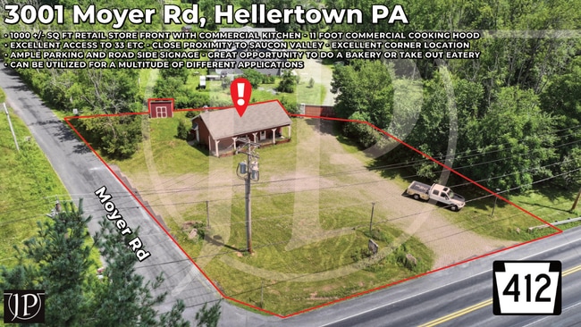
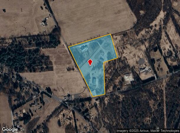
3001 Moyer Rd, Hellertown, PA 18055
Current Lease Availabilities
NEARBY LISTINGS FOR SALE OR LEASE
Property Detail
3001 Moyer Rd
Philadelphia-Camden-Wilmington, PA-NJ-DE-MD
Gallagher Land Project
42-012-051-005
Bucks
Residentialnec
Pennsylvania
A
14.82 AC
42017C0041J
Upper Bucks County
5,463 SF
Philadelphia
DEMOGRAPHICS near 3001 Moyer Rd
1 Mile
3 Mile
5 Mile
2024 Total Population
456
9,509
31,746
2029 Population
447
9,627
32,481
Pop Growth 2024-2029
(1.97%)
+ 1.24%
+ 2.32%
Average Age
47
45
43
2024 Total Households
179
3,784
12,045
HH Growth 2024-2029
(2.23%)
+ 1.29%
+ 2.36%
Median Household Inc
$135,326
$117,065
$103,433
Avg Household Size
2.50
2.40
2.50
2024 Avg HH Vehicles
2.00
2.00
2.00
Median Home Value
$551,887
$392,577
$420,386
Median Year Built
1969
1961
1972
Nearby Places
Map Layers
Map Styles
 Street
 Aerial
- Restaurants
- Banks
- Shops
- Fitness
- Groceries
PUBLIC TRANSPORTATION
AIRPORT
Lehigh Valley International
DRIVE
WALK
Distance
Lehigh Valley International
28 min
13.8 mi
Freight Ports
Port of Philadelphia
DRIVE
WALK
Distance
Port of Philadelphia
79 min
47.5 mi
Nearby Properties
Address
Land Use
TOTAL SIZE
Lot Size
Zoning
Address
Land Use
TOTAL SIZE
Lot Size
Zoning
151,013 SF
104.20 AC
R12
Address
Land Use
TOTAL SIZE
Lot Size
Zoning
77,319 SF
15.62 AC
GB
Address
Land Use
TOTAL SIZE
Lot Size
Zoning
2,567 SF
180.51 AC
R-1
Address
Land Use
TOTAL SIZE
Lot Size
Zoning
27,379 SF
2.68 AC
SC
Address
Land Use
TOTAL SIZE
Lot Size
Zoning
38,742 SF
0.44 AC
TC
Address
Land Use
TOTAL SIZE
Lot Size
Zoning
11,596 SF
0.58 AC
TC
Address
Land Use
TOTAL SIZE
Lot Size
Zoning
19,899 SF
4 AC
R2
Address
Land Use
TOTAL SIZE
Lot Size
Zoning
20,092 SF
5 AC
R40
Address
Land Use
TOTAL SIZE
Lot Size
Zoning
48,421 SF
15.29 AC
R40
Address
Land Use
TOTAL SIZE
Lot Size
Zoning
10,274 SF
0.80 AC
TC
Address
Land Use
TOTAL SIZE
Lot Size
Zoning
14,780 SF
1.49 AC
M
Address
Land Use
TOTAL SIZE
Lot Size
Zoning
81.09 AC
R40
Address
Land Use
TOTAL SIZE
Lot Size
Zoning
28.70 AC
R-1
Address
Land Use
TOTAL SIZE
Lot Size
Zoning
19,168 SF
2.36 AC
SC
Address
Land Use
TOTAL SIZE
Lot Size
Zoning
22,827 SF
1.04 AC
C
Address
Land Use
TOTAL SIZE
Lot Size
Zoning
1,730 SF
92.50 AC
RA
Address
Land Use
TOTAL SIZE
Lot Size
Zoning
30 AC
R-1
Address
Land Use
TOTAL SIZE
Lot Size
Zoning
4,207 SF
47.89 AC
C
Address
Land Use
TOTAL SIZE
Lot Size
Zoning
5,186 SF
3.70 AC
C
Address
Land Use
TOTAL SIZE
Lot Size
Zoning
12,182 SF
7.12 AC
R40
Address
Land Use
TOTAL SIZE
Lot Size
Zoning
3,928 SF
0.47 AC
R-1
Address
Land Use
TOTAL SIZE
Lot Size
Zoning
10,840 SF
0.87 AC
TC
Address
Land Use
TOTAL SIZE
Lot Size
Zoning
3,198 SF
14.90 AC
R40
Address
Land Use
TOTAL SIZE
Lot Size
Zoning
86 AC
RA
Address
Land Use
TOTAL SIZE
Lot Size
Zoning
22.29 AC
R-1
Address
Land Use
TOTAL SIZE
Lot Size
Zoning
9,232 SF
0.50 AC
M
Address
Land Use
TOTAL SIZE
Lot Size
Zoning
5,772 SF
0.82 AC
M
Address
Land Use
TOTAL SIZE
Lot Size
Zoning
4,112 SF
0.68 AC
TC
Address
Land Use
TOTAL SIZE
Lot Size
Zoning
5,894 SF
1.50 AC
C
Address
Land Use
TOTAL SIZE
Lot Size
Zoning
2,864 SF
0.76 AC
M
The World's #1 Commercial Real Estate Marketplace
Connect with us
© 2026 CoStar Group
The information above has been obtained from sources believed reliable. While we do not doubt its accuracy we have not verified it and make no guarantee, warranty or representation about it. It is your responsibility to independently confirm its accuracy and completeness. Any projections, opinions, assumptions, or estimates used are for example only and do not represent the current or future performance of the property. The value of this transaction to you depends on tax and other factors which should be evaluated by your tax, financial, and legal advisors. You and your advisors should conduct a careful, independent investigation of the property to determine to your satisfaction the suitability of the property for your needs.