Property Record
3003 S 25Th E, Ammon, ID 83406
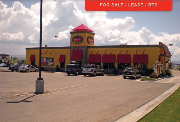

Property Detail
3003 S 25Th E
Idaho Falls, ID
LOT 9, BLOCK 3, RICKS FARM AMENDED # 6 LOT 10, BLOCK 3, RICKS FARM AMENDED # 7, NW1/4 & SW1/4 SEC 27, T 2N, R 38
RPB3314003009A
Bonneville
Restaurantdrivein
Idaho
2025
9
2025
1.34 AC
970502
Idaho South Area
4,685 SF
Other Market Areas
NEARBY LISTINGS FOR SALE OR LEASE
DEMOGRAPHICS near 3003 S 25Th E
1 mile
3 mile
5 mile
2025 Total Population
8,361
72,093
112,305
2030 Population
8,864
76,016
118,437
Pop Growth 2025-2030
+ 6.02%
+ 5.44%
+ 5.46%
Average Age
39
37
36
2025 Total Households
3,016
25,540
39,018
HH Growth 2025-2030
+ 6.20%
+ 5.50%
+ 5.52%
Median Household Inc
$70,395
$68,628
$71,197
Avg Household Size
2.60
2.70
2.80
2025 Avg HH Vehicles
2.00
2.00
2.00
Median Home Value
$372,574
$360,140
$371,755
Median Year Built
1998
1990
1991
Nearby Places
Map Layers
Map Styles
 Street
 Aerial
Transit
 Traffic
 Biking
Places
Listings with unknown addresses are not visible on the map
- Restaurants
- Banks
- Shops
- Fitness
- Groceries
PUBLIC TRANSPORTATION
AIRPORT
Idaho Falls Regional
Drive
Walk
Distance
Idaho Falls Regional
16 min
7.4 mi
Freight Ports
Port of Portland
Drive
Walk
Distance
Port of Portland
744 min
712.0 mi
Nearby Properties
Address
Land Use
TOTAL SIZE
Lot Size
Zoning
Address
Land Use
TOTAL SIZE
Lot Size
Zoning
159,026 SF
13.94 AC
R2
Address
Land Use
TOTAL SIZE
Lot Size
Zoning
375,295 SF
26.11 AC
R2
Address
Land Use
TOTAL SIZE
Lot Size
Zoning
267,740 SF
45.91 AC
Address
Land Use
TOTAL SIZE
Lot Size
Zoning
4,813 SF
13.50 AC
Address
Land Use
TOTAL SIZE
Lot Size
Zoning
4,363 SF
13.28 AC
Address
Land Use
TOTAL SIZE
Lot Size
Zoning
200,984 SF
10.65 AC
R2
Address
Land Use
TOTAL SIZE
Lot Size
Zoning
106,733 SF
2.99 AC
Address
Land Use
TOTAL SIZE
Lot Size
Zoning
1,908 SF
5.77 AC
Address
Land Use
TOTAL SIZE
Lot Size
Zoning
6,300 SF
15.21 AC
Address
Land Use
TOTAL SIZE
Lot Size
Zoning
210,995 SF
24.15 AC
R2
Address
Land Use
TOTAL SIZE
Lot Size
Zoning
800 SF
8.38 AC
Address
Land Use
TOTAL SIZE
Lot Size
Zoning
179,244 SF
16.56 AC
Address
Land Use
TOTAL SIZE
Lot Size
Zoning
7,617 SF
4.65 AC
Address
Land Use
TOTAL SIZE
Lot Size
Zoning
129,350 SF
4.87 AC
R2
Address
Land Use
TOTAL SIZE
Lot Size
Zoning
6,300 SF
11.42 AC
Address
Land Use
TOTAL SIZE
Lot Size
Zoning
1,472 SF
4.38 AC
Address
Land Use
TOTAL SIZE
Lot Size
Zoning
25,889 SF
2.91 AC
Address
Land Use
TOTAL SIZE
Lot Size
Zoning
4,074 SF
10.06 AC
R2
Address
Land Use
TOTAL SIZE
Lot Size
Zoning
93,971 SF
9.38 AC
R2
Address
Land Use
TOTAL SIZE
Lot Size
Zoning
5,584 SF
6.74 AC
Address
Land Use
TOTAL SIZE
Lot Size
Zoning
140,391 SF
17.57 AC
R2
Address
Land Use
TOTAL SIZE
Lot Size
Zoning
28,978 SF
2.40 AC
Address
Land Use
TOTAL SIZE
Lot Size
Zoning
59,941 SF
11.99 AC
Address
Land Use
TOTAL SIZE
Lot Size
Zoning
122,067 SF
10.51 AC
Address
Land Use
TOTAL SIZE
Lot Size
Zoning
216 SF
3.58 AC
Address
Land Use
TOTAL SIZE
Lot Size
Zoning
53,973 SF
7.45 AC
Address
Land Use
TOTAL SIZE
Lot Size
Zoning
133,191 SF
12.38 AC
Address
Land Use
TOTAL SIZE
Lot Size
Zoning
74,869 SF
8.82 AC
R2
Address
Land Use
TOTAL SIZE
Lot Size
Zoning
70,764 SF
3 AC
R2
Address
Land Use
TOTAL SIZE
Lot Size
Zoning
115,576 SF
12.08 AC
R2
The World's #1 Commercial Real Estate Marketplace
Connect with us
© 2026 CoStar Group
The information above has been obtained from sources believed reliable. While we do not doubt its accuracy we have not verified it and make no guarantee, warranty or representation about it. It is your responsibility to independently confirm its accuracy and completeness. Any projections, opinions, assumptions, or estimates used are for example only and do not represent the current or future performance of the property. The value of this transaction to you depends on tax and other factors which should be evaluated by your tax, financial, and legal advisors. You and your advisors should conduct a careful, independent investigation of the property to determine to your satisfaction the suitability of the property for your needs.