Property Record
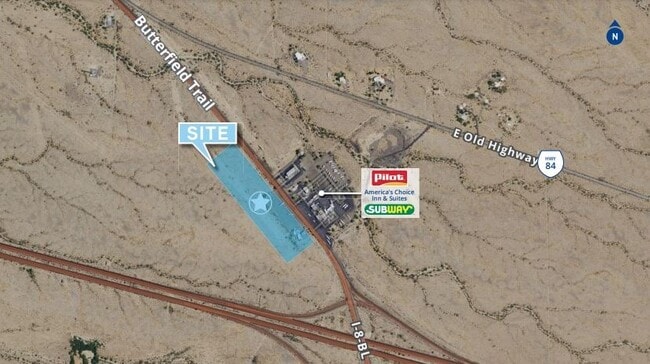
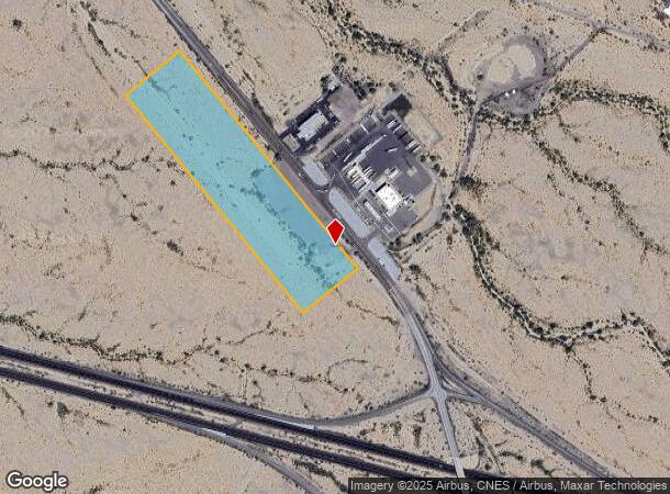
3006 S Butterfield Trl, Gila Bend, AZ 85337
NEARBY LISTINGS FOR SALE OR LEASE
-
-
View all Gila Bend listings for sale on LoopNet.com
Property Detail
3006 S Butterfield Trl
Phoenix-Mesa-Scottsdale, AZ
Lot Combination Pilot Gila Bend North
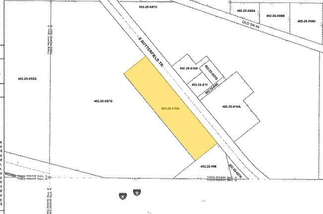
402-25-015A
S2 OF SEC 4 DAF COM S4 COR SD SEC TH N 07D 01M W 385.45F TH N 38D 58M W 198.90F POB TH S 51D 01M W 420.01F TH N 38D 58M W 1681.11F TH N 51D 01M E 420.01F TH S 38D 58M E 1681.11F TPOB P/F 20-023281 (LOT 3)
Commercialacreage
Maricopa
X
Arizona
04013C3566L
16.21 AC
2025
Southwest Outlying
2025
Phoenix
723305
DEMOGRAPHICS near 3006 S Butterfield Trl
1 Mile
3 Mile
5 Mile
2024 Total Population
15
993
1,608
2029 Population
15
1,000
1,616
Pop Growth 2024-2029
0.00%
+ 0.70%
+ 0.50%
Average Age
35
37
36
2024 Total Households
4
221
416
HH Growth 2024-2029
0.00%
+ 0.45%
+ 0.24%
Median Household Inc
$42,500
$44,341
$46,875
Avg Household Size
3.00
3.30
3.20
2024 Avg HH Vehicles
2.00
2.00
2.00
Median Home Value
$750,000
$98,386
$91,599
Median Year Built
1977
1976
1976
Nearby Places
Map Layers
Map Styles
 Street
 Aerial
- Restaurants
- Banks
- Shops
- Fitness
- Groceries
SALE & LEASE HISTORY
LISTING DATE
SALE/LEASE

Sep 28, 2020
For Sale
Nearby Properties
Address
Land Use
TOTAL SIZE
Lot Size
Zoning
Address
Land Use
TOTAL SIZE
Lot Size
Zoning
11,895 SF
11.01 AC
Address
Land Use
TOTAL SIZE
Lot Size
Zoning
8,502 SF
1.67 AC
M-M
Address
Land Use
TOTAL SIZE
Lot Size
Zoning
24,405 SF
20.26 AC
I-2
Address
Land Use
TOTAL SIZE
Lot Size
Zoning
2,068 SF
7.76 AC
R-7
Address
Land Use
TOTAL SIZE
Lot Size
Zoning
99,777 SF
19.10 AC
I-2
Address
Land Use
TOTAL SIZE
Lot Size
Zoning
22,560 SF
1.72 AC
C-C
Address
Land Use
TOTAL SIZE
Lot Size
Zoning
2,880 SF
159 AC
R-190
Address
Land Use
TOTAL SIZE
Lot Size
Zoning
25,841 SF
2.34 AC
C-C
Address
Land Use
TOTAL SIZE
Lot Size
Zoning
141.59 AC
I-1
Address
Land Use
TOTAL SIZE
Lot Size
Zoning
34,206 SF
6.23 AC
M-H
Address
Land Use
TOTAL SIZE
Lot Size
Zoning
9,504 SF
5.65 AC
I-1
Address
Land Use
TOTAL SIZE
Lot Size
Zoning
15,506 SF
1.14 AC
C-C
Address
Land Use
TOTAL SIZE
Lot Size
Zoning
8,880 SF
1.37 AC
C-C
Address
Land Use
TOTAL SIZE
Lot Size
Zoning
2,870 SF
23.78 AC
I-2
Address
Land Use
TOTAL SIZE
Lot Size
Zoning
10,440 SF
0.27 AC
C-C
Address
Land Use
TOTAL SIZE
Lot Size
Zoning
19,865 SF
2 AC
M-H
Address
Land Use
TOTAL SIZE
Lot Size
Zoning
3,598 SF
4.30 AC
C-C
Address
Land Use
TOTAL SIZE
Lot Size
Zoning
4,662 SF
6.68 AC
I-1
Address
Land Use
TOTAL SIZE
Lot Size
Zoning
7,898 SF
0.46 AC
C-C
Address
Land Use
TOTAL SIZE
Lot Size
Zoning
7,889 SF
1.82 AC
C-C
Address
Land Use
TOTAL SIZE
Lot Size
Zoning
11,736 SF
0.23 AC
C-C
Address
Land Use
TOTAL SIZE
Lot Size
Zoning
6,609 SF
12.72 AC
I-1
Address
Land Use
TOTAL SIZE
Lot Size
Zoning
2,975 SF
23.30 AC
MHP
Address
Land Use
TOTAL SIZE
Lot Size
Zoning
38.87 AC
I-2
Address
Land Use
TOTAL SIZE
Lot Size
Zoning
7,366 SF
0.76 AC
R-7
Address
Land Use
TOTAL SIZE
Lot Size
Zoning
3,520 SF
7.36 AC
I-1
Address
Land Use
TOTAL SIZE
Lot Size
Zoning
8,576 SF
0.30 AC
C-C
The World's #1 Commercial Real Estate Marketplace
Connect with us
© 2025 CoStar Group
The information above has been obtained from sources believed reliable. While we do not doubt its accuracy we have not verified it and make no guarantee, warranty or representation about it. It is your responsibility to independently confirm its accuracy and completeness. Any projections, opinions, assumptions, or estimates used are for example only and do not represent the current or future performance of the property. The value of this transaction to you depends on tax and other factors which should be evaluated by your tax, financial, and legal advisors. You and your advisors should conduct a careful, independent investigation of the property to determine to your satisfaction the suitability of the property for your needs.