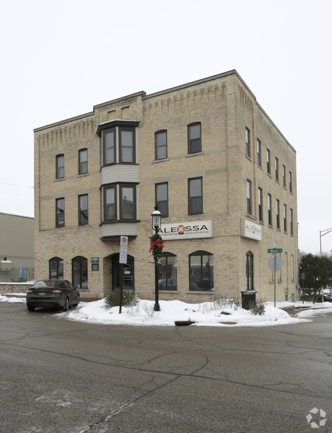
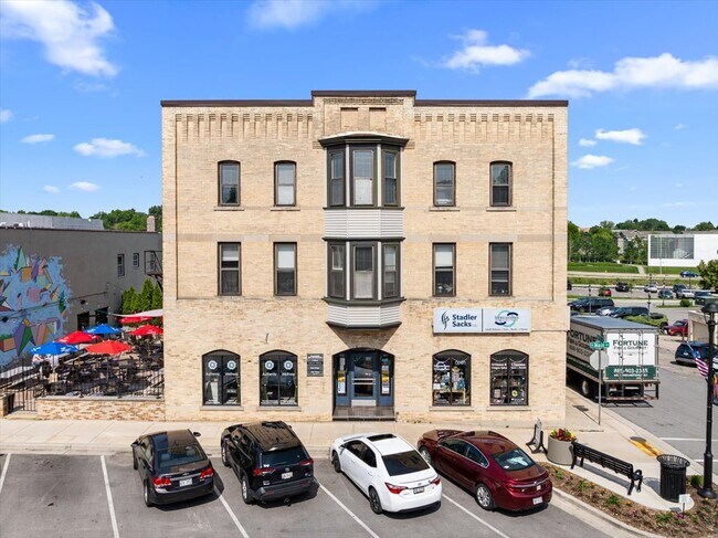
Property Record
303 N Main St, Hartford, WI 53027
NEARBY LISTINGS FOR SALE OR LEASE
-
-
View all Hartford listings for sale on LoopNet.com
Property Detail
303 N Main St
Milwaukee-Waukesha-West Allis, WI
Original Plat Of The Village Of Hartford
36-2001016001
ORIGINAL PLAT S55' OF E65' LOT 1 BLK 2 DOC 1470934
Commercialnec
Washington
X
Wisconsin
55131C0209E
1
2024
0.10 AC
2024
North Washington
440200
Milwaukee/Madison
5,824 SF
DEMOGRAPHICS near 303 N Main St
1 Mile
3 Mile
5 Mile
2024 Total Population
9,717
37,272
45,491
2029 Population
9,983
38,168
46,671
Pop Growth 2024-2029
+ 2.74%
+ 2.40%
+ 2.59%
Average Age
41
42
43
2024 Total Households
4,330
16,089
19,348
HH Growth 2024-2029
+ 2.86%
+ 2.49%
+ 2.68%
Median Household Inc
$67,302
$69,426
$73,002
Avg Household Size
2.10
2.30
2.30
2024 Avg HH Vehicles
2.00
2.00
2.00
Median Home Value
$187,786
$235,484
$255,860
Median Year Built
1957
1976
1977
Nearby Places
Map Layers
Map Styles
 Street
 Aerial
- Restaurants
- Banks
- Shops
- Fitness
- Groceries
PUBLIC TRANSPORTATION
AIRPORT
General Mitchell International
DRIVE
WALK
Distance
General Mitchell International
62 min
44.2 mi
Freight Ports
Port Milwaukee
DRIVE
WALK
Distance
Port Milwaukee
56 min
40.5 mi
SALE & LEASE HISTORY
LISTING DATE
SALE/LEASE

Jan 29, 2020
For Lease
Dec 27, 2016
For Lease
Aug 11, 2025
For Sale
Nearby Properties
Address
Land Use
TOTAL SIZE
Lot Size
Zoning
Address
Land Use
TOTAL SIZE
Lot Size
Zoning
90.37 AC
Address
Land Use
TOTAL SIZE
Lot Size
Zoning
49,735 SF
9.99 AC
Address
Land Use
TOTAL SIZE
Lot Size
Zoning
13,314 SF
16.91 AC
Address
Land Use
TOTAL SIZE
Lot Size
Zoning
70,221 SF
7.09 AC
Address
Land Use
TOTAL SIZE
Lot Size
Zoning
94,819 SF
0.18 AC
Address
Land Use
TOTAL SIZE
Lot Size
Zoning
22,814 SF
8.85 AC
Address
Land Use
TOTAL SIZE
Lot Size
Zoning
20.24 AC
Address
Land Use
TOTAL SIZE
Lot Size
Zoning
11.63 AC
Address
Land Use
TOTAL SIZE
Lot Size
Zoning
184,928 SF
22.37 AC
Address
Land Use
TOTAL SIZE
Lot Size
Zoning
145,216 SF
21.86 AC
Address
Land Use
TOTAL SIZE
Lot Size
Zoning
15,408 SF
9.39 AC
Address
Land Use
TOTAL SIZE
Lot Size
Zoning
20.10 AC
Address
Land Use
TOTAL SIZE
Lot Size
Zoning
57,888 SF
2.45 AC
Address
Land Use
TOTAL SIZE
Lot Size
Zoning
15.34 AC
Address
Land Use
TOTAL SIZE
Lot Size
Zoning
36.28 AC
Address
Land Use
TOTAL SIZE
Lot Size
Zoning
Address
Land Use
TOTAL SIZE
Lot Size
Zoning
37,038 SF
1.02 AC
Address
Land Use
TOTAL SIZE
Lot Size
Zoning
8.10 AC
Address
Land Use
TOTAL SIZE
Lot Size
Zoning
6,620 SF
1.26 AC
Address
Land Use
TOTAL SIZE
Lot Size
Zoning
13.14 AC
Address
Land Use
TOTAL SIZE
Lot Size
Zoning
26,340 SF
5.01 AC
Address
Land Use
TOTAL SIZE
Lot Size
Zoning
11.68 AC
Address
Land Use
TOTAL SIZE
Lot Size
Zoning
21.55 AC
Address
Land Use
TOTAL SIZE
Lot Size
Zoning
5.03 AC
Address
Land Use
TOTAL SIZE
Lot Size
Zoning
Address
Land Use
TOTAL SIZE
Lot Size
Zoning
5.09 AC
Address
Land Use
TOTAL SIZE
Lot Size
Zoning
36,686 SF
1.86 AC
Address
Land Use
TOTAL SIZE
Lot Size
Zoning
Address
Land Use
TOTAL SIZE
Lot Size
Zoning
63,705 SF
6.85 AC
Address
Land Use
TOTAL SIZE
Lot Size
Zoning
55,326 SF
1.37 AC
The World's #1 Commercial Real Estate Marketplace
Connect with us
© 2025 CoStar Group
The information above has been obtained from sources believed reliable. While we do not doubt its accuracy we have not verified it and make no guarantee, warranty or representation about it. It is your responsibility to independently confirm its accuracy and completeness. Any projections, opinions, assumptions, or estimates used are for example only and do not represent the current or future performance of the property. The value of this transaction to you depends on tax and other factors which should be evaluated by your tax, financial, and legal advisors. You and your advisors should conduct a careful, independent investigation of the property to determine to your satisfaction the suitability of the property for your needs.