Property Record
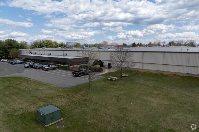
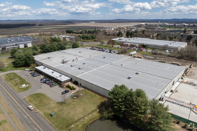
301 Griffith Rd, Chicopee, MA 01022

Property Detail
301 Griffith Rd
Manufacturinglight
Hampden
110
Massachusetts
B and X Area of moderate flood hazard, usually the area between the limits of the 100-year and 500-year floods.
11.36 AC
2025
Hampden County
2025
Hartford
811302
Springfield, MA
152,380 SF
CHIC-000004-000000-W000010
NEARBY LISTINGS FOR SALE OR LEASE
DEMOGRAPHICS near 301 Griffith Rd
1 mile
3 mile
5 mile
2025 Total Population
26,770
63,790
153,665
2030 Population
27,493
64,583
154,114
Pop Growth 2025-2030
+ 2.70%
+ 1.24%
+ 0.29%
Average Age
41
42
41
2025 Total Households
11,173
26,990
62,718
HH Growth 2025-2030
+ 2.96%
+ 1.34%
+ 0.32%
Median Household Inc
$64,086
$64,721
$63,745
Avg Household Size
2.40
2.30
2.30
2025 Avg HH Vehicles
2.00
2.00
2.00
Median Home Value
$274,349
$280,328
$284,408
Median Year Built
2011
1983
1960
Nearby Places
Map Layers
Map Styles
 Street
 Aerial
Layers
 Traffic
 Biking
Places
Listings with unknown addresses are not visible on the map
- Restaurants
- Banks
- Shops
- Fitness
- Groceries
PUBLIC TRANSPORTATION
COMMUTER RAIL
Drive
Walk
Distance
10 min
4.0 mi
Drive
Walk
Distance
19 min
9.0 mi
AIRPORT
Bradley International
Drive
Walk
Distance
Bradley International
49 min
22.3 mi
SALE & LEASE HISTORY
LISTING DATE
SALE/LEASE

May 03, 2022
For Sale
Nearby Properties
Address
Land Use
TOTAL SIZE
Lot Size
Zoning
Address
Land Use
TOTAL SIZE
Lot Size
Zoning
21.80 AC
106
Address
Land Use
TOTAL SIZE
Lot Size
Zoning
22.77 AC
111A
Address
Land Use
TOTAL SIZE
Lot Size
Zoning
171,241 SF
18.94 AC
106
Address
Land Use
TOTAL SIZE
Lot Size
Zoning
30.45 AC
106
Address
Land Use
TOTAL SIZE
Lot Size
Zoning
223,390 SF
13.83 AC
111A
Address
Land Use
TOTAL SIZE
Lot Size
Zoning
26.68 AC
110
Address
Land Use
TOTAL SIZE
Lot Size
Zoning
2.41 AC
DR
Address
Land Use
TOTAL SIZE
Lot Size
Zoning
4.04 AC
107
Address
Land Use
TOTAL SIZE
Lot Size
Zoning
257,179 SF
22.84 AC
110
Address
Land Use
TOTAL SIZE
Lot Size
Zoning
34 AC
Address
Land Use
TOTAL SIZE
Lot Size
Zoning
109,136 SF
5.01 AC
Address
Land Use
TOTAL SIZE
Lot Size
Zoning
81.65 AC
110
Address
Land Use
TOTAL SIZE
Lot Size
Zoning
320,639 SF
14.16 AC
110
Address
Land Use
TOTAL SIZE
Lot Size
Zoning
23,111 SF
1.43 AC
IA
Address
Land Use
TOTAL SIZE
Lot Size
Zoning
491.50 AC
108
Address
Land Use
TOTAL SIZE
Lot Size
Zoning
243.13 AC
109
Address
Land Use
TOTAL SIZE
Lot Size
Zoning
194,875 SF
2.75 AC
IG
Address
Land Use
TOTAL SIZE
Lot Size
Zoning
64,638 SF
9.26 AC
RA2
Address
Land Use
TOTAL SIZE
Lot Size
Zoning
14.47 AC
110
Address
Land Use
TOTAL SIZE
Lot Size
Zoning
116,625 SF
12.73 AC
111A
Address
Land Use
TOTAL SIZE
Lot Size
Zoning
43,289 SF
2.63 AC
DR
Address
Land Use
TOTAL SIZE
Lot Size
Zoning
80,393 SF
1.71 AC
111
Address
Land Use
TOTAL SIZE
Lot Size
Zoning
10.62 AC
111A
Address
Land Use
TOTAL SIZE
Lot Size
Zoning
217,640 SF
12.21 AC
110
Address
Land Use
TOTAL SIZE
Lot Size
Zoning
88,603 SF
3.28 AC
111A
Address
Land Use
TOTAL SIZE
Lot Size
Zoning
17.97 AC
108
Address
Land Use
TOTAL SIZE
Lot Size
Zoning
2.03 AC
111
Address
Land Use
TOTAL SIZE
Lot Size
Zoning
78,505 SF
10.68 AC
111
Address
Land Use
TOTAL SIZE
Lot Size
Zoning
291,714 SF
35.75 AC
110
The World's #1 Commercial Real Estate Marketplace
Connect with us
© 2026 CoStar Group
The information above has been obtained from sources believed reliable. While we do not doubt its accuracy we have not verified it and make no guarantee, warranty or representation about it. It is your responsibility to independently confirm its accuracy and completeness. Any projections, opinions, assumptions, or estimates used are for example only and do not represent the current or future performance of the property. The value of this transaction to you depends on tax and other factors which should be evaluated by your tax, financial, and legal advisors. You and your advisors should conduct a careful, independent investigation of the property to determine to your satisfaction the suitability of the property for your needs.