Property Record
301 Laurel View Dr, Smithfield, PA 15478

NEARBY LISTINGS FOR SALE OR LEASE
-
-
View all Smithfield listings for lease on LoopNet.com
Property Detail
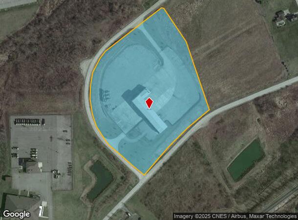
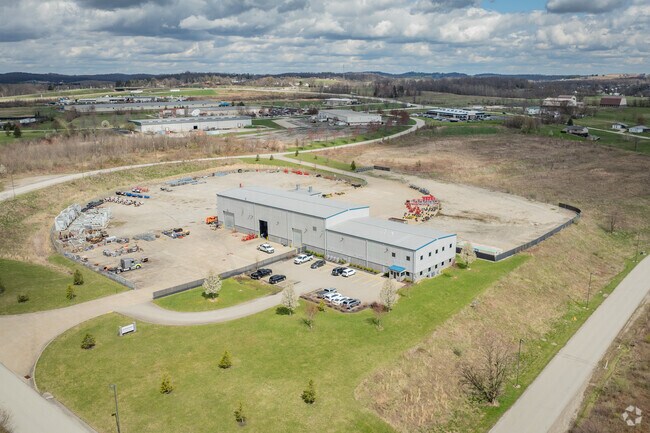
301 Laurel View Dr
Pittsburgh, PA
Fayette Industrial Fund Plan No 7
14-25-0207-22
10 AC (LOT 1) HEAVY INDUSTRIAL
Heavyindustrial
Fayette
X
Pennsylvania
42051C0492E
1
2025
10 AC
2025
Fayette County
262800
Pittsburgh
DEMOGRAPHICS near 301 Laurel View Dr
1 mile
3 mile
5 mile
2024 Total Population
911
7,133
12,357
2029 Population
891
6,979
12,100
Pop Growth 2024-2029
(2.20%)
(2.16%)
(2.08%)
Average Age
42
43
43
2024 Total Households
362
2,924
5,075
HH Growth 2024-2029
(2.21%)
(2.39%)
(2.31%)
Median Household Inc
$73,541
$57,307
$53,781
Avg Household Size
2.50
2.40
2.40
2024 Avg HH Vehicles
2.00
2.00
2.00
Median Home Value
$163,792
$142,272
$144,928
Median Year Built
1952
1956
1959
Nearby Places
Map Layers
Map Styles
 Street
 Aerial
Transit
 Traffic
 Biking
Places
Listings with unknown addresses are not visible on the map
- Restaurants
- Banks
- Shops
- Fitness
- Groceries
SALE & LEASE HISTORY
LISTING DATE
SALE/LEASE

Jun 27, 2019
For Lease
Jun 27, 2019
For Sale
Jul 16, 2019
For Sale
Jan 31, 2024
For Lease
Jan 31, 2024
For Sale
Nearby Properties
Address
Land Use
TOTAL SIZE
Lot Size
Zoning
Address
Land Use
TOTAL SIZE
Lot Size
Zoning
51.99 AC
Address
Land Use
TOTAL SIZE
Lot Size
Zoning
2.12 AC
Address
Land Use
TOTAL SIZE
Lot Size
Zoning
24.48 AC
Address
Land Use
TOTAL SIZE
Lot Size
Zoning
Address
Land Use
TOTAL SIZE
Lot Size
Zoning
Address
Land Use
TOTAL SIZE
Lot Size
Zoning
10.31 AC
Address
Land Use
TOTAL SIZE
Lot Size
Zoning
142,684 SF
15.45 AC
Address
Land Use
TOTAL SIZE
Lot Size
Zoning
20.99 AC
Address
Land Use
TOTAL SIZE
Lot Size
Zoning
1,603 SF
25.36 AC
Address
Land Use
TOTAL SIZE
Lot Size
Zoning
12.48 AC
Address
Land Use
TOTAL SIZE
Lot Size
Zoning
Address
Land Use
TOTAL SIZE
Lot Size
Zoning
Address
Land Use
TOTAL SIZE
Lot Size
Zoning
10.72 AC
Address
Land Use
TOTAL SIZE
Lot Size
Zoning
13.79 AC
Address
Land Use
TOTAL SIZE
Lot Size
Zoning
5.88 AC
Address
Land Use
TOTAL SIZE
Lot Size
Zoning
15,000 SF
7.10 AC
Address
Land Use
TOTAL SIZE
Lot Size
Zoning
Address
Land Use
TOTAL SIZE
Lot Size
Zoning
24,768 SF
6.46 AC
Address
Land Use
TOTAL SIZE
Lot Size
Zoning
Address
Land Use
TOTAL SIZE
Lot Size
Zoning
25,272 SF
3.36 AC
Address
Land Use
TOTAL SIZE
Lot Size
Zoning
5.43 AC
Address
Land Use
TOTAL SIZE
Lot Size
Zoning
75,900 SF
4 AC
Address
Land Use
TOTAL SIZE
Lot Size
Zoning
2.04 AC
Address
Land Use
TOTAL SIZE
Lot Size
Zoning
22,800 SF
5.76 AC
Address
Land Use
TOTAL SIZE
Lot Size
Zoning
2.79 AC
Address
Land Use
TOTAL SIZE
Lot Size
Zoning
Address
Land Use
TOTAL SIZE
Lot Size
Zoning
3.16 AC
Address
Land Use
TOTAL SIZE
Lot Size
Zoning
Address
Land Use
TOTAL SIZE
Lot Size
Zoning
1,107 AC
The World's #1 Commercial Real Estate Marketplace
Connect with us
© 2026 CoStar Group
The information above has been obtained from sources believed reliable. While we do not doubt its accuracy we have not verified it and make no guarantee, warranty or representation about it. It is your responsibility to independently confirm its accuracy and completeness. Any projections, opinions, assumptions, or estimates used are for example only and do not represent the current or future performance of the property. The value of this transaction to you depends on tax and other factors which should be evaluated by your tax, financial, and legal advisors. You and your advisors should conduct a careful, independent investigation of the property to determine to your satisfaction the suitability of the property for your needs.