Property Record
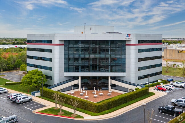
301 Nw 63Rd St, Oklahoma City, OK 73116


Current Lease Availabilities
NEARBY LISTINGS FOR SALE OR LEASE
Property Detail
301 Nw 63Rd St
132968000
Unpltd Pt Sec 04 12N 3W
Taxexempt
UNPLTD PT SEC 04 12N 3W 000 000 PT SE4 SEC 4 12N 3W BEG 825FT W OF SE/C SW4 SE4 TH N411.18FT E460FT S361.18FT W359.88FT S50FT W100.59FT TO BEG SUBJ TO ESMTS OF RECORD
X
Oklahoma
40109C0170H
Oklahoma
0
3.81 AC
2024
North
106200
Oklahoma City
116,153 SF
Oklahoma City, OK
DEMOGRAPHICS near 301 Nw 63Rd St
1 Mile
3 Mile
5 Mile
2024 Total Population
3,072
59,868
172,381
2029 Population
3,154
61,589
177,709
Pop Growth 2024-2029
+ 2.67%
+ 2.87%
+ 3.09%
Average Age
40
39
38
2024 Total Households
1,470
27,479
79,740
HH Growth 2024-2029
+ 2.79%
+ 2.92%
+ 3.19%
Median Household Inc
$66,258
$54,102
$50,849
Avg Household Size
2.00
2.10
2.10
2024 Avg HH Vehicles
2.00
2.00
2.00
Median Home Value
$207,292
$206,542
$179,748
Median Year Built
1969
1958
1963
Nearby Places
Map Layers
Map Styles
 Street
 Aerial
- Restaurants
- Banks
- Shops
- Fitness
- Groceries
PUBLIC TRANSPORTATION
COMMUTER RAIL
DRIVE
WALK
Distance
10 min
5.5 mi
AIRPORT
Will Rogers World
DRIVE
WALK
Distance
Will Rogers World
26 min
14.4 mi
Nearby Properties
Address
Land Use
TOTAL SIZE
Lot Size
Zoning
Address
Land Use
TOTAL SIZE
Lot Size
Zoning
233,053 SF
18.93 AC
O-2
Address
Land Use
TOTAL SIZE
Lot Size
Zoning
819,976 SF
21.87 AC
C-3
Address
Land Use
TOTAL SIZE
Lot Size
Zoning
442,553 SF
58.86 AC
PUD
Address
Land Use
TOTAL SIZE
Lot Size
Zoning
777,727 SF
54.25 AC
I-2
Address
Land Use
TOTAL SIZE
Lot Size
Zoning
467,216 SF
66.90 AC
C-3
Address
Land Use
TOTAL SIZE
Lot Size
Zoning
58,071 SF
4.15 AC
PUD
Address
Land Use
TOTAL SIZE
Lot Size
Zoning
327,248 SF
14.22 AC
R-4
Address
Land Use
TOTAL SIZE
Lot Size
Zoning
294,583 SF
20.14 AC
PUD
Address
Land Use
TOTAL SIZE
Lot Size
Zoning
93,244 SF
7.54 AC
PUD
Address
Land Use
TOTAL SIZE
Lot Size
Zoning
202,147 SF
44.36 AC
PUD
Address
Land Use
TOTAL SIZE
Lot Size
Zoning
485,764 SF
6.05 AC
C-3
Address
Land Use
TOTAL SIZE
Lot Size
Zoning
452,123 SF
5.64 AC
O-2
Address
Land Use
TOTAL SIZE
Lot Size
Zoning
10,922 SF
1.04 AC
SPUD
Address
Land Use
TOTAL SIZE
Lot Size
Zoning
377,880 SF
24.34 AC
PUD
Address
Land Use
TOTAL SIZE
Lot Size
Zoning
258,381 SF
2.54 AC
PUD
Address
Land Use
TOTAL SIZE
Lot Size
Zoning
254,126 SF
2.11 AC
SPUD
Address
Land Use
TOTAL SIZE
Lot Size
Zoning
105,426 SF
15.58 AC
O-2
Address
Land Use
TOTAL SIZE
Lot Size
Zoning
26,340 SF
2.38 AC
NC
Address
Land Use
TOTAL SIZE
Lot Size
Zoning
21,000 SF
2.64 AC
I-1
Address
Land Use
TOTAL SIZE
Lot Size
Zoning
244,699 SF
11.83 AC
C-3
Address
Land Use
TOTAL SIZE
Lot Size
Zoning
681,708 SF
20.54 AC
C-3
Address
Land Use
TOTAL SIZE
Lot Size
Zoning
189,504 SF
5.74 AC
Address
Land Use
TOTAL SIZE
Lot Size
Zoning
160,389 SF
16.48 AC
PUD
Address
Land Use
TOTAL SIZE
Lot Size
Zoning
436,316 SF
5.23 AC
I-1
Address
Land Use
TOTAL SIZE
Lot Size
Zoning
285,771 SF
8.64 AC
PUD
Address
Land Use
TOTAL SIZE
Lot Size
Zoning
1 SF
3.72 AC
C-3
Address
Land Use
TOTAL SIZE
Lot Size
Zoning
198,422 SF
4.17 AC
O-2
Address
Land Use
TOTAL SIZE
Lot Size
Zoning
167,057 SF
2.62 AC
PUD
Address
Land Use
TOTAL SIZE
Lot Size
Zoning
142,592 SF
6.60 AC
PUD
The World's #1 Commercial Real Estate Marketplace
Connect with us
© 2026 CoStar Group
The information above has been obtained from sources believed reliable. While we do not doubt its accuracy we have not verified it and make no guarantee, warranty or representation about it. It is your responsibility to independently confirm its accuracy and completeness. Any projections, opinions, assumptions, or estimates used are for example only and do not represent the current or future performance of the property. The value of this transaction to you depends on tax and other factors which should be evaluated by your tax, financial, and legal advisors. You and your advisors should conduct a careful, independent investigation of the property to determine to your satisfaction the suitability of the property for your needs.