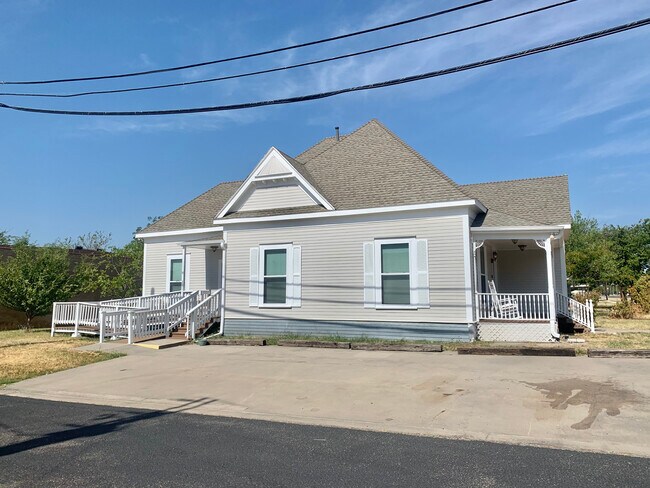
Property Record
301 W Main St, Gunter, TX 75058


NEARBY LISTINGS FOR SALE OR LEASE
Property Detail
301 W Main St
Sherman-Denison, TX
Otp Gunter
151913
OTP GUNTER, BLOCK 33, LOT 10 & N 105 11 & 12, 75 X 105 X 50 X 25 X 145
Commercialnec
Grayson
X
Texas
48181C0525F
10
2024
0.20 AC
2025
Texas East Area
001901
Other Market Areas
1,515 SF
DEMOGRAPHICS near 301 W Main St
1 Mile
3 Mile
5 Mile
2024 Total Population
1,211
3,492
5,047
2029 Population
1,347
3,962
5,862
Pop Growth 2024-2029
+ 11.23%
+ 13.46%
+ 16.15%
Average Age
35
37
37
2024 Total Households
384
1,114
1,610
HH Growth 2024-2029
+ 11.72%
+ 14.00%
+ 16.58%
Median Household Inc
$81,626
$131,718
$137,747
Avg Household Size
3.10
3.10
3.10
2024 Avg HH Vehicles
2.00
3.00
3.00
Median Home Value
$251,041
$431,481
$442,307
Median Year Built
1986
2003
2005
Nearby Places
Map Layers
Map Styles
 Street
 Aerial
- Restaurants
- Banks
- Shops
- Fitness
- Groceries
SALE & LEASE HISTORY
LISTING DATE
SALE/LEASE

Dec 20, 2017
For Lease
Dec 09, 2022
For Lease
Nearby Properties
Address
Land Use
TOTAL SIZE
Lot Size
Zoning
Address
Land Use
TOTAL SIZE
Lot Size
Zoning
28,882 SF
156.87 AC
Address
Land Use
TOTAL SIZE
Lot Size
Zoning
148,140 SF
55.50 AC
Address
Land Use
TOTAL SIZE
Lot Size
Zoning
151,330 SF
44.86 AC
Address
Land Use
TOTAL SIZE
Lot Size
Zoning
59,691 SF
4.48 AC
Address
Land Use
TOTAL SIZE
Lot Size
Zoning
15,680 SF
21.03 AC
Address
Land Use
TOTAL SIZE
Lot Size
Zoning
43,280 SF
24.74 AC
Address
Land Use
TOTAL SIZE
Lot Size
Zoning
29,239 SF
7.61 AC
Address
Land Use
TOTAL SIZE
Lot Size
Zoning
19.25 AC
Address
Land Use
TOTAL SIZE
Lot Size
Zoning
10,800 SF
Address
Land Use
TOTAL SIZE
Lot Size
Zoning
13,400 SF
11.50 AC
Address
Land Use
TOTAL SIZE
Lot Size
Zoning
33,488 SF
3.17 AC
Address
Land Use
TOTAL SIZE
Lot Size
Zoning
6,400 SF
Address
Land Use
TOTAL SIZE
Lot Size
Zoning
1,080 SF
24.91 AC
Address
Land Use
TOTAL SIZE
Lot Size
Zoning
30,800 SF
2 AC
Address
Land Use
TOTAL SIZE
Lot Size
Zoning
9,288 SF
1.40 AC
Address
Land Use
TOTAL SIZE
Lot Size
Zoning
9,396 SF
1.70 AC
Address
Land Use
TOTAL SIZE
Lot Size
Zoning
Address
Land Use
TOTAL SIZE
Lot Size
Zoning
7,225 SF
0.76 AC
Address
Land Use
TOTAL SIZE
Lot Size
Zoning
4,291 SF
1.38 AC
Address
Land Use
TOTAL SIZE
Lot Size
Zoning
17,890 SF
96.80 AC
Address
Land Use
TOTAL SIZE
Lot Size
Zoning
12,366 SF
6.16 AC
Address
Land Use
TOTAL SIZE
Lot Size
Zoning
16,102 SF
45.22 AC
Address
Land Use
TOTAL SIZE
Lot Size
Zoning
7,410 SF
3.29 AC
Address
Land Use
TOTAL SIZE
Lot Size
Zoning
39,388 SF
5.12 AC
Address
Land Use
TOTAL SIZE
Lot Size
Zoning
51,488 SF
2.96 AC
Address
Land Use
TOTAL SIZE
Lot Size
Zoning
224 SF
10.19 AC
Address
Land Use
TOTAL SIZE
Lot Size
Zoning
9,146 SF
1.23 AC
Address
Land Use
TOTAL SIZE
Lot Size
Zoning
5,149 SF
30.51 AC
Address
Land Use
TOTAL SIZE
Lot Size
Zoning
5,894 SF
10.16 AC
The World's #1 Commercial Real Estate Marketplace
Connect with us
© 2025 CoStar Group
The information above has been obtained from sources believed reliable. While we do not doubt its accuracy we have not verified it and make no guarantee, warranty or representation about it. It is your responsibility to independently confirm its accuracy and completeness. Any projections, opinions, assumptions, or estimates used are for example only and do not represent the current or future performance of the property. The value of this transaction to you depends on tax and other factors which should be evaluated by your tax, financial, and legal advisors. You and your advisors should conduct a careful, independent investigation of the property to determine to your satisfaction the suitability of the property for your needs.