Property Record
3015 Five Forks Trickum Rd Sw, Lilburn, GA 30047
NEARBY LISTINGS FOR SALE OR LEASE
Property Detail
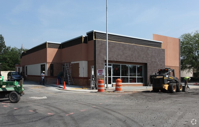
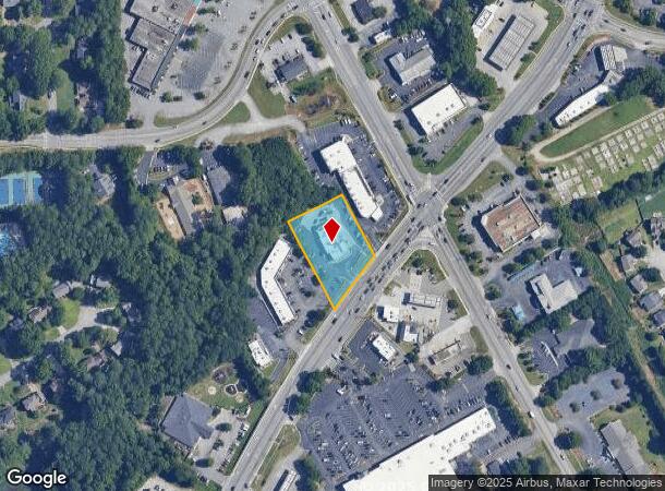
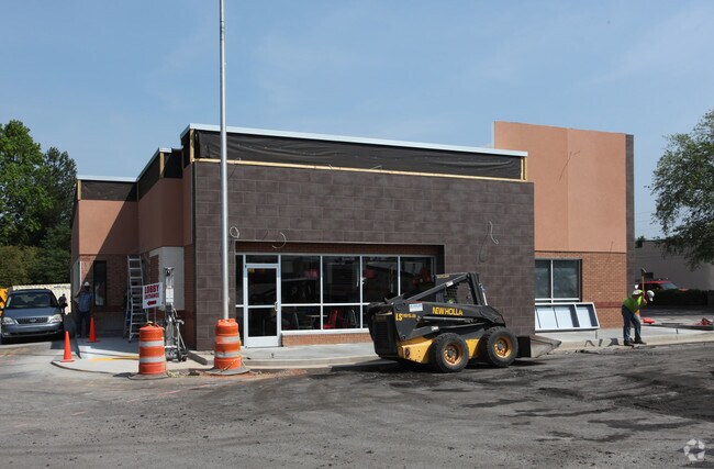
3015 Five Forks Trickum Rd Sw
6-106-383
Trickum
Restaurantdrivein
FIVE FORKS-TRICKUM RD
X
Gwinnett
13135C0115F
Georgia
0
1.01 AC
2025
Lilburn/Snellville
050760
Atlanta
4,675 SF
Atlanta-Sandy Springs-Roswell, GA
DEMOGRAPHICS near 3015 Five Forks Trickum Rd Sw
1 mile
3 mile
5 mile
2024 Total Population
7,834
75,103
222,450
2029 Population
8,157
78,400
231,886
Pop Growth 2024-2029
+ 4.12%
+ 4.39%
+ 4.24%
Average Age
39
38
38
2024 Total Households
2,539
23,455
71,160
HH Growth 2024-2029
+ 4.21%
+ 4.46%
+ 4.32%
Median Household Inc
$107,587
$94,912
$77,265
Avg Household Size
3.00
3.10
3.10
2024 Avg HH Vehicles
2.00
2.00
2.00
Median Home Value
$329,679
$312,545
$286,362
Median Year Built
1985
1988
1989
Nearby Places
Map Layers
Map Styles
 Street
 Aerial
Transit
 Traffic
 Biking
Places
Listings with unknown addresses are not visible on the map
- Restaurants
- Banks
- Shops
- Fitness
- Groceries
PUBLIC TRANSPORTATION
AIRPORT
Hartsfield - Jackson Atlanta International
Drive
Walk
Distance
Hartsfield - Jackson Atlanta International
50 min
32.2 mi
Nearby Properties
Address
Land Use
TOTAL SIZE
Lot Size
Zoning
Address
Land Use
TOTAL SIZE
Lot Size
Zoning
362,674 SF
43.59 AC
CI
Address
Land Use
TOTAL SIZE
Lot Size
Zoning
313,246 SF
17.15 AC
RM13
Address
Land Use
TOTAL SIZE
Lot Size
Zoning
245,208 SF
15.37 AC
RO
Address
Land Use
TOTAL SIZE
Lot Size
Zoning
300,402 SF
24.55 AC
RM13
Address
Land Use
TOTAL SIZE
Lot Size
Zoning
274,964 SF
27.82 AC
BG
Address
Land Use
TOTAL SIZE
Lot Size
Zoning
230,417 SF
24.09 AC
BG
Address
Land Use
TOTAL SIZE
Lot Size
Zoning
214,082 SF
18.56 AC
BG
Address
Land Use
TOTAL SIZE
Lot Size
Zoning
140,309 SF
26.34 AC
R75
Address
Land Use
TOTAL SIZE
Lot Size
Zoning
148,880 SF
23.15 AC
R100
Address
Land Use
TOTAL SIZE
Lot Size
Zoning
125,097 SF
1.01 AC
CI
Address
Land Use
TOTAL SIZE
Lot Size
Zoning
357,243 SF
59.63 AC
R100
Address
Land Use
TOTAL SIZE
Lot Size
Zoning
123,713 SF
5.97 AC
C2
Address
Land Use
TOTAL SIZE
Lot Size
Zoning
53,071 SF
142.06 AC
R75
Address
Land Use
TOTAL SIZE
Lot Size
Zoning
38,438 SF
130.10 AC
R100
Address
Land Use
TOTAL SIZE
Lot Size
Zoning
97,856 SF
8.72 AC
C2
Address
Land Use
TOTAL SIZE
Lot Size
Zoning
122,201 SF
10.23 AC
BG
Address
Land Use
TOTAL SIZE
Lot Size
Zoning
100,913 SF
8.30 AC
HSB
Address
Land Use
TOTAL SIZE
Lot Size
Zoning
106,114 SF
16.59 AC
C2
Address
Land Use
TOTAL SIZE
Lot Size
Zoning
97,411 SF
8.47 AC
BG
Address
Land Use
TOTAL SIZE
Lot Size
Zoning
55,810 SF
8.28 AC
R100
Address
Land Use
TOTAL SIZE
Lot Size
Zoning
89,686 SF
18.29 AC
C2
Address
Land Use
TOTAL SIZE
Lot Size
Zoning
61,200 SF
0.59 AC
CI
Address
Land Use
TOTAL SIZE
Lot Size
Zoning
193,216 SF
14.19 AC
M2
Address
Land Use
TOTAL SIZE
Lot Size
Zoning
66,544 SF
6.70 AC
BG
Address
Land Use
TOTAL SIZE
Lot Size
Zoning
82,087 SF
10.03 AC
C2
Address
Land Use
TOTAL SIZE
Lot Size
Zoning
77,284 SF
3.93 AC
C2
Address
Land Use
TOTAL SIZE
Lot Size
Zoning
68,193 SF
3.05 AC
BG
Address
Land Use
TOTAL SIZE
Lot Size
Zoning
34.28 AC
M2
Address
Land Use
TOTAL SIZE
Lot Size
Zoning
230,323 SF
15 AC
R100
Address
Land Use
TOTAL SIZE
Lot Size
Zoning
83,316 SF
7 AC
R100
The World's #1 Commercial Real Estate Marketplace
Connect with us
© 2026 CoStar Group
The information above has been obtained from sources believed reliable. While we do not doubt its accuracy we have not verified it and make no guarantee, warranty or representation about it. It is your responsibility to independently confirm its accuracy and completeness. Any projections, opinions, assumptions, or estimates used are for example only and do not represent the current or future performance of the property. The value of this transaction to you depends on tax and other factors which should be evaluated by your tax, financial, and legal advisors. You and your advisors should conduct a careful, independent investigation of the property to determine to your satisfaction the suitability of the property for your needs.