Property Record
3015 Sw Pine Island Rd, Cape Coral, FL 33991

NEARBY LISTINGS FOR SALE OR LEASE
Property Detail
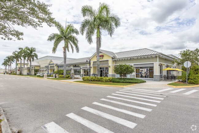
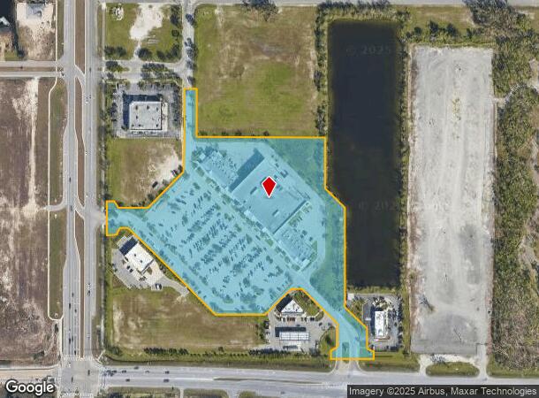
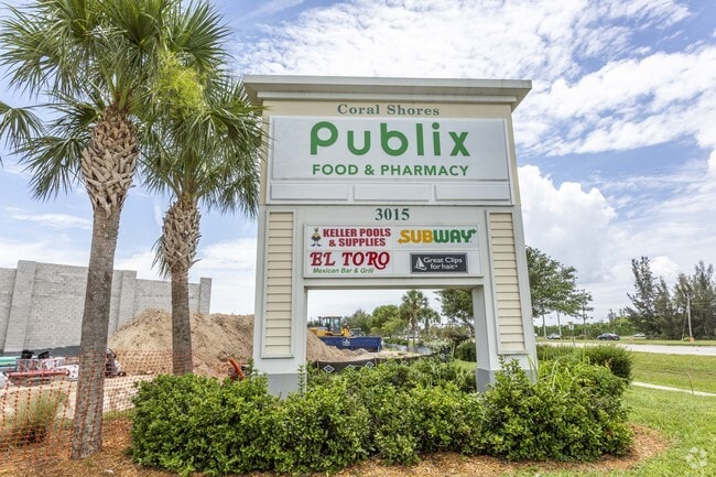
3015 Sw Pine Island Rd
17-44-23-C4-0010D.0000
Pine Island Rd Corridor
Regionalshoppingcenterormallwithanchorstore
CORAL SHORES DESC IN PB 80 PGS 77-78 TRACT D
AE
Lee
12071C0243G
Florida
2024
11.39 AC
2025
Cape Coral
010108
Southwest Florida
78,938 SF
Cape Coral-Fort Myers, FL
DEMOGRAPHICS near 3015 Sw Pine Island Rd
1 Mile
3 Mile
5 Mile
2024 Total Population
4,518
36,440
101,322
2029 Population
5,473
43,813
121,277
Pop Growth 2024-2029
+ 21.14%
+ 20.23%
+ 19.69%
Average Age
45
42
42
2024 Total Households
1,732
13,318
36,603
HH Growth 2024-2029
+ 20.50%
+ 19.81%
+ 19.23%
Median Household Inc
$78,709
$74,927
$73,369
Avg Household Size
2.60
2.70
2.70
2024 Avg HH Vehicles
2.00
2.00
2.00
Median Home Value
$352,647
$307,653
$286,333
Median Year Built
2010
2006
2004
Nearby Places
Map Layers
Map Styles
 Street
 Aerial
- Restaurants
- Banks
- Shops
- Fitness
- Groceries
PUBLIC TRANSPORTATION
AIRPORT
Punta Gorda
DRIVE
WALK
Distance
Punta Gorda
35 min
21.3 mi
Southwest Florida International
DRIVE
WALK
Distance
Southwest Florida International
42 min
25.7 mi
SALE & LEASE HISTORY
LISTING DATE
SALE/LEASE

Sep 24, 2016
For Lease
Nov 07, 2024
For Lease
Nearby Properties
Address
Land Use
TOTAL SIZE
Lot Size
Zoning
Address
Land Use
TOTAL SIZE
Lot Size
Zoning
507,243 SF
115.38 AC
A
Address
Land Use
TOTAL SIZE
Lot Size
Zoning
300,366 SF
10.61 AC
RPUD
Address
Land Use
TOTAL SIZE
Lot Size
Zoning
264,848 SF
10.36 AC
CORR
Address
Land Use
TOTAL SIZE
Lot Size
Zoning
4.89 AC
C-1
Address
Land Use
TOTAL SIZE
Lot Size
Zoning
239,211 SF
56.31 AC
INST
Address
Land Use
TOTAL SIZE
Lot Size
Zoning
27.77 AC
RML
Address
Land Use
TOTAL SIZE
Lot Size
Zoning
149,829 SF
5.70 AC
R-3
Address
Land Use
TOTAL SIZE
Lot Size
Zoning
123,133 SF
8.26 AC
C
Address
Land Use
TOTAL SIZE
Lot Size
Zoning
147,599 SF
5.72 AC
RML
Address
Land Use
TOTAL SIZE
Lot Size
Zoning
142,379 SF
3.27 AC
Address
Land Use
TOTAL SIZE
Lot Size
Zoning
62,119 SF
6.50 AC
CORR
Address
Land Use
TOTAL SIZE
Lot Size
Zoning
64,461 SF
27.05 AC
RD-D
Address
Land Use
TOTAL SIZE
Lot Size
Zoning
28,560 SF
5.08 AC
P1-W
Address
Land Use
TOTAL SIZE
Lot Size
Zoning
102,818 SF
8.60 AC
CORR
Address
Land Use
TOTAL SIZE
Lot Size
Zoning
93,636 SF
4.46 AC
C-1
Address
Land Use
TOTAL SIZE
Lot Size
Zoning
78,740 SF
4.51 AC
C-1
Address
Land Use
TOTAL SIZE
Lot Size
Zoning
47,423 SF
13.86 AC
R1-D
Address
Land Use
TOTAL SIZE
Lot Size
Zoning
56,092 SF
4.52 AC
CORR
Address
Land Use
TOTAL SIZE
Lot Size
Zoning
20.12 AC
RD
Address
Land Use
TOTAL SIZE
Lot Size
Zoning
48,402 SF
6.20 AC
Address
Land Use
TOTAL SIZE
Lot Size
Zoning
16.86 AC
RD
Address
Land Use
TOTAL SIZE
Lot Size
Zoning
29,429 SF
3.27 AC
Address
Land Use
TOTAL SIZE
Lot Size
Zoning
45,121 SF
15.54 AC
RD-D
Address
Land Use
TOTAL SIZE
Lot Size
Zoning
41,231 SF
10.24 AC
A
Address
Land Use
TOTAL SIZE
Lot Size
Zoning
86,383 SF
4.87 AC
CORR
Address
Land Use
TOTAL SIZE
Lot Size
Zoning
17.21 AC
CORR
Address
Land Use
TOTAL SIZE
Lot Size
Zoning
9.23 AC
RPUD
Address
Land Use
TOTAL SIZE
Lot Size
Zoning
61,338 SF
5.79 AC
CORR
Address
Land Use
TOTAL SIZE
Lot Size
Zoning
47,054 SF
3.65 AC
CORR
The World's #1 Commercial Real Estate Marketplace
Connect with us
© 2025 CoStar Group
The information above has been obtained from sources believed reliable. While we do not doubt its accuracy we have not verified it and make no guarantee, warranty or representation about it. It is your responsibility to independently confirm its accuracy and completeness. Any projections, opinions, assumptions, or estimates used are for example only and do not represent the current or future performance of the property. The value of this transaction to you depends on tax and other factors which should be evaluated by your tax, financial, and legal advisors. You and your advisors should conduct a careful, independent investigation of the property to determine to your satisfaction the suitability of the property for your needs.