Property Record
305 Suffield St, Agawam, MA 01001
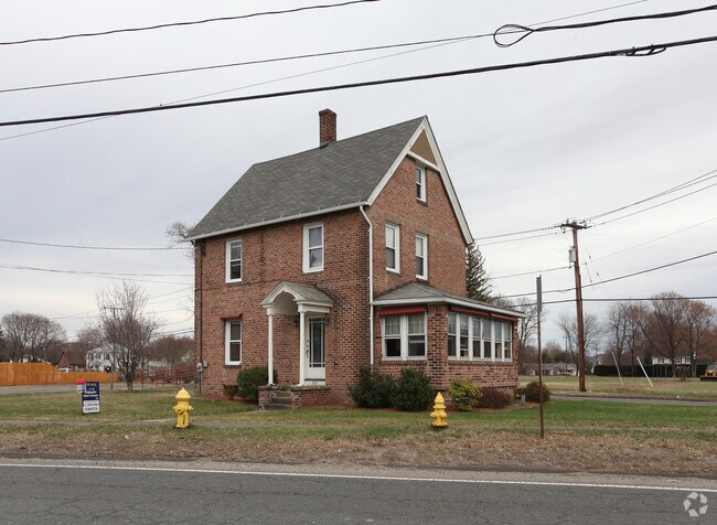

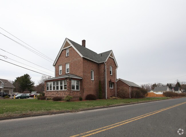
Property Detail
305 Suffield St
AGAW-000012J-000004-000006
Hampden
Commercialbuilding
Massachusetts
BA
6
B and X Area of moderate flood hazard, usually the area between the limits of the 100-year and 500-year floods.
0.27 AC
2025
Hampden County
2025
Hartford
813207
Springfield, MA
3,509 SF
NEARBY LISTINGS FOR SALE OR LEASE
DEMOGRAPHICS near 305 Suffield St
1 mile
3 mile
5 mile
2025 Total Population
6,830
62,257
172,529
2030 Population
6,834
62,049
171,907
Pop Growth 2025-2030
+ 0.06%
(0.33%)
(0.36%)
Average Age
44
41
39
2025 Total Households
2,764
26,324
66,591
HH Growth 2025-2030
(0.07%)
(0.29%)
(0.38%)
Median Household Inc
$74,859
$52,082
$58,019
Avg Household Size
2.30
2.30
2.40
2025 Avg HH Vehicles
2.00
1.00
1.00
Median Home Value
$302,915
$314,971
$304,902
Median Year Built
1958
1955
1952
Nearby Places
Map Layers
Map Styles
 Street
 Aerial
Layers
 Traffic
 Biking
Places
Listings with unknown addresses are not visible on the map
- Restaurants
- Banks
- Shops
- Fitness
- Groceries
PUBLIC TRANSPORTATION
COMMUTER RAIL
Drive
Walk
Distance
6 min
3.4 mi
AIRPORT
Bradley International
Drive
Walk
Distance
Bradley International
23 min
10.7 mi
Nearby Properties
Address
Land Use
TOTAL SIZE
Lot Size
Zoning
Address
Land Use
TOTAL SIZE
Lot Size
Zoning
257,525 SF
64.03 AC
Address
Land Use
TOTAL SIZE
Lot Size
Zoning
82,248 SF
4.57 AC
SR3C1
Address
Land Use
TOTAL SIZE
Lot Size
Zoning
227,072 SF
4.37 AC
B3
Address
Land Use
TOTAL SIZE
Lot Size
Zoning
839,347 SF
2.05 AC
B3
Address
Land Use
TOTAL SIZE
Lot Size
Zoning
36.53 AC
IB
Address
Land Use
TOTAL SIZE
Lot Size
Zoning
200,000 SF
13.91 AC
R3
Address
Land Use
TOTAL SIZE
Lot Size
Zoning
100,000 SF
17.80 AC
WC
Address
Land Use
TOTAL SIZE
Lot Size
Zoning
236,032 SF
41.65 AC
RA2
Address
Land Use
TOTAL SIZE
Lot Size
Zoning
8,712 SF
25.08 AC
RA1
Address
Land Use
TOTAL SIZE
Lot Size
Zoning
115,600 SF
4.25 AC
B2
Address
Land Use
TOTAL SIZE
Lot Size
Zoning
42,412 SF
2.22 AC
SR2B1
Address
Land Use
TOTAL SIZE
Lot Size
Zoning
24,835 SF
2.16 AC
B3
Address
Land Use
TOTAL SIZE
Lot Size
Zoning
201,800 SF
6.27 AC
R5
Address
Land Use
TOTAL SIZE
Lot Size
Zoning
335,105 SF
1.28 AC
B3
Address
Land Use
TOTAL SIZE
Lot Size
Zoning
186,700 SF
11.17 AC
SR3R5
Address
Land Use
TOTAL SIZE
Lot Size
Zoning
1,840 SF
148.78 AC
BB
Address
Land Use
TOTAL SIZE
Lot Size
Zoning
77,012 SF
1.29 AC
B3
Address
Land Use
TOTAL SIZE
Lot Size
Zoning
137,450 SF
16 AC
Address
Land Use
TOTAL SIZE
Lot Size
Zoning
57,593 SF
2.15 AC
SR3C1
Address
Land Use
TOTAL SIZE
Lot Size
Zoning
184,850 SF
2.39 AC
B3
Address
Land Use
TOTAL SIZE
Lot Size
Zoning
229,164 SF
3.80 AC
R5
Address
Land Use
TOTAL SIZE
Lot Size
Zoning
426,795 SF
3.99 AC
B3
Address
Land Use
TOTAL SIZE
Lot Size
Zoning
133,822 SF
40.51 AC
RA2
Address
Land Use
TOTAL SIZE
Lot Size
Zoning
126,360 SF
3.39 AC
SB1B2
Address
Land Use
TOTAL SIZE
Lot Size
Zoning
171,105 SF
14.21 AC
Address
Land Use
TOTAL SIZE
Lot Size
Zoning
63,684 SF
4.33 AC
B2
Address
Land Use
TOTAL SIZE
Lot Size
Zoning
155,803 SF
0.87 AC
B3
Address
Land Use
TOTAL SIZE
Lot Size
Zoning
74,634 SF
1.37 AC
R3
Address
Land Use
TOTAL SIZE
Lot Size
Zoning
51,400 SF
0.59 AC
B3
Address
Land Use
TOTAL SIZE
Lot Size
Zoning
80,144 SF
CR
The World's #1 Commercial Real Estate Marketplace
Connect with us
© 2026 CoStar Group
The information above has been obtained from sources believed reliable. While we do not doubt its accuracy we have not verified it and make no guarantee, warranty or representation about it. It is your responsibility to independently confirm its accuracy and completeness. Any projections, opinions, assumptions, or estimates used are for example only and do not represent the current or future performance of the property. The value of this transaction to you depends on tax and other factors which should be evaluated by your tax, financial, and legal advisors. You and your advisors should conduct a careful, independent investigation of the property to determine to your satisfaction the suitability of the property for your needs.