Property Record
3059 E Main St, Ventura, CA 93003
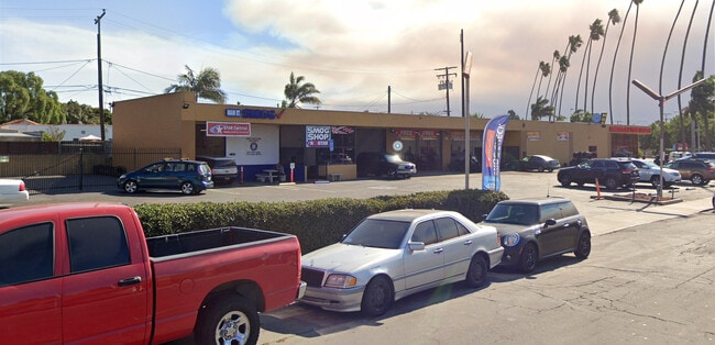

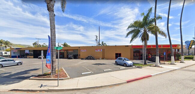

This Property Is For Sale
Property Detail
3059 E Main St
077-0-074-185
MAP 20 PG 25 LOT 28-30
Vehiclerentalsvehiclesales
Ventura
C2
California
B and X Area of moderate flood hazard, usually the area between the limits of the 100-year and 500-year floods.
0.63 AC
2024
Ventura
2025
Los Angeles
002700
Oxnard-Thousand Oaks-Ventura, CA
7,338 SF
NEARBY LISTINGS FOR SALE OR LEASE
DEMOGRAPHICS near 3059 E Main St
1 mile
3 mile
5 mile
2025 Total Population
15,803
62,893
121,622
2030 Population
15,814
63,164
121,627
Pop Growth 2025-2030
+ 0.07%
+ 0.43%
0.00%
Average Age
42
43
42
2025 Total Households
6,397
25,531
45,182
HH Growth 2025-2030
(0.03%)
+ 0.44%
(0.02%)
Median Household Inc
$110,088
$96,264
$105,105
Avg Household Size
2.40
2.40
2.60
2025 Avg HH Vehicles
2.00
2.00
2.00
Median Home Value
$894,187
$853,439
$806,380
Median Year Built
1957
1967
1973
Nearby Places
Map Layers
Map Styles
 Street
 Aerial
Transit
 Traffic
 Biking
Places
Listings with unknown addresses are not visible on the map
- Restaurants
- Banks
- Shops
- Fitness
- Groceries
PUBLIC TRANSPORTATION
COMMUTER RAIL
Drive
Walk
Distance
9 min
3.3 mi
Drive
Walk
Distance
7 min
3.5 mi
Nearby Properties
Address
Land Use
TOTAL SIZE
Lot Size
Zoning
Address
Land Use
TOTAL SIZE
Lot Size
Zoning
1.99 AC
Address
Land Use
TOTAL SIZE
Lot Size
Zoning
4.19 AC
H
Address
Land Use
TOTAL SIZE
Lot Size
Zoning
43,284 SF
14.34 AC
RPD28
Address
Land Use
TOTAL SIZE
Lot Size
Zoning
195,798 SF
15.40 AC
RPD15
Address
Land Use
TOTAL SIZE
Lot Size
Zoning
233,168 SF
13.94 AC
RPD-
Address
Land Use
TOTAL SIZE
Lot Size
Zoning
176,598 SF
9.22 AC
Address
Land Use
TOTAL SIZE
Lot Size
Zoning
Address
Land Use
TOTAL SIZE
Lot Size
Zoning
49,296 SF
11.08 AC
Address
Land Use
TOTAL SIZE
Lot Size
Zoning
7,280 SF
5.38 AC
C-T-O
Address
Land Use
TOTAL SIZE
Lot Size
Zoning
3.01 AC
Address
Land Use
TOTAL SIZE
Lot Size
Zoning
40,110 SF
8.04 AC
MPD
Address
Land Use
TOTAL SIZE
Lot Size
Zoning
6.81 AC
C-T-O
Address
Land Use
TOTAL SIZE
Lot Size
Zoning
2.89 AC
C-T-O
Address
Land Use
TOTAL SIZE
Lot Size
Zoning
89,643 SF
14.27 AC
Address
Land Use
TOTAL SIZE
Lot Size
Zoning
13,530 SF
10.85 AC
Address
Land Use
TOTAL SIZE
Lot Size
Zoning
25,401 SF
2.74 AC
C1AD
Address
Land Use
TOTAL SIZE
Lot Size
Zoning
81,671 SF
3.54 AC
Address
Land Use
TOTAL SIZE
Lot Size
Zoning
639.79 AC
Address
Land Use
TOTAL SIZE
Lot Size
Zoning
111,421 SF
3.80 AC
Address
Land Use
TOTAL SIZE
Lot Size
Zoning
107,360 SF
5.96 AC
RPD15
Address
Land Use
TOTAL SIZE
Lot Size
Zoning
36,186 SF
12.16 AC
Address
Land Use
TOTAL SIZE
Lot Size
Zoning
73,272 SF
6.05 AC
C1AD
Address
Land Use
TOTAL SIZE
Lot Size
Zoning
58,841 SF
6.74 AC
CPD
Address
Land Use
TOTAL SIZE
Lot Size
Zoning
76,449 SF
6.88 AC
CPD
Address
Land Use
TOTAL SIZE
Lot Size
Zoning
65,192 SF
3.20 AC
RPD-
Address
Land Use
TOTAL SIZE
Lot Size
Zoning
3.26 AC
PO
Address
Land Use
TOTAL SIZE
Lot Size
Zoning
96,277 SF
7.72 AC
Address
Land Use
TOTAL SIZE
Lot Size
Zoning
68,148 SF
3.75 AC
P-O
Address
Land Use
TOTAL SIZE
Lot Size
Zoning
The World's #1 Commercial Real Estate Marketplace
Connect with us
© 2026 CoStar Group
The information above has been obtained from sources believed reliable. While we do not doubt its accuracy we have not verified it and make no guarantee, warranty or representation about it. It is your responsibility to independently confirm its accuracy and completeness. Any projections, opinions, assumptions, or estimates used are for example only and do not represent the current or future performance of the property. The value of this transaction to you depends on tax and other factors which should be evaluated by your tax, financial, and legal advisors. You and your advisors should conduct a careful, independent investigation of the property to determine to your satisfaction the suitability of the property for your needs.