Property Record
310 Mccrary Rd, Pendleton, SC 29670

NEARBY LISTINGS FOR SALE OR LEASE
-
-
View all Pendleton listings for sale on LoopNet.com
Property Detail
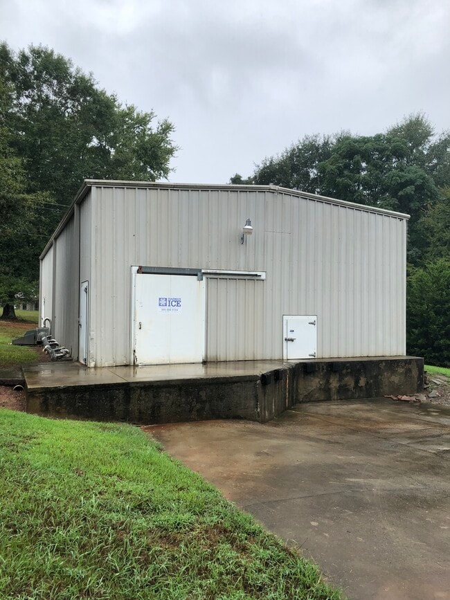
310 Mccrary Rd
Greenville-Anderson-Greer, SC
Pendleton Township
041-03-03-022
CP 000/000 PP 043/223 F000 D000 PT LT 1 WALNUT DR .11 AC
Warehouse
Anderson
X
South Carolina
45007C0094E
1
2025
0.11 AC
2024
Outlying Anderson Co
010702
Greenville/Spartanburg
1,090 SF
DEMOGRAPHICS near 310 Mccrary Rd
1 Mile
3 Mile
5 Mile
2024 Total Population
1,870
8,883
29,342
2029 Population
2,043
9,573
30,794
Pop Growth 2024-2029
+ 9.25%
+ 7.77%
+ 4.95%
Average Age
41
40
36
2024 Total Households
881
3,669
10,690
HH Growth 2024-2029
+ 9.53%
+ 8.48%
+ 5.77%
Median Household Inc
$51,634
$62,159
$56,858
Avg Household Size
2.10
2.30
2.30
2024 Avg HH Vehicles
2.00
2.00
2.00
Median Home Value
$197,846
$194,796
$253,050
Median Year Built
1994
1990
1992
Nearby Places
Map Layers
Map Styles
 Street
 Aerial
- Restaurants
- Banks
- Shops
- Fitness
- Groceries
PUBLIC TRANSPORTATION
COMMUTER RAIL
Clemson Amtrak Station (Crescent - Amtrak)
DRIVE
WALK
Distance
Clemson Amtrak Station (Crescent - Amtrak)
10 min
5.8 mi
Freight Ports
Georgia Ports - Savannah
DRIVE
WALK
Distance
Georgia Ports - Savannah
309 min
222.0 mi
SALE & LEASE HISTORY
LISTING DATE
SALE/LEASE

Sep 17, 2021
For Sale
Jan 07, 2025
For Sale
Feb 08, 2023
For Sale
Feb 07, 2023
For Lease
Feb 07, 2022
For Sale
Nearby Properties
Address
Land Use
TOTAL SIZE
Lot Size
Zoning
Address
Land Use
TOTAL SIZE
Lot Size
Zoning
254,000 SF
94.59 AC
Address
Land Use
TOTAL SIZE
Lot Size
Zoning
11.42 AC
Address
Land Use
TOTAL SIZE
Lot Size
Zoning
5,484.32 AC
Address
Land Use
TOTAL SIZE
Lot Size
Zoning
6,000 SF
0.99 AC
Address
Land Use
TOTAL SIZE
Lot Size
Zoning
75,260 SF
2.20 AC
Address
Land Use
TOTAL SIZE
Lot Size
Zoning
6,500 SF
7.41 AC
Address
Land Use
TOTAL SIZE
Lot Size
Zoning
1.52 AC
Address
Land Use
TOTAL SIZE
Lot Size
Zoning
14,706 SF
8.48 AC
Address
Land Use
TOTAL SIZE
Lot Size
Zoning
20,000 SF
14.18 AC
Address
Land Use
TOTAL SIZE
Lot Size
Zoning
27.50 AC
Address
Land Use
TOTAL SIZE
Lot Size
Zoning
69,208 SF
10.68 AC
Address
Land Use
TOTAL SIZE
Lot Size
Zoning
1,530 SF
41.37 AC
Address
Land Use
TOTAL SIZE
Lot Size
Zoning
38.90 AC
Address
Land Use
TOTAL SIZE
Lot Size
Zoning
14.58 AC
R 20 SINGL
Address
Land Use
TOTAL SIZE
Lot Size
Zoning
5,839 SF
5.45 AC
Address
Land Use
TOTAL SIZE
Lot Size
Zoning
3,730 SF
1.98 AC
Address
Land Use
TOTAL SIZE
Lot Size
Zoning
174.15 AC
Address
Land Use
TOTAL SIZE
Lot Size
Zoning
9,600 SF
1.79 AC
Address
Land Use
TOTAL SIZE
Lot Size
Zoning
6,282 SF
2.92 AC
Address
Land Use
TOTAL SIZE
Lot Size
Zoning
10,054 SF
1.20 AC
Address
Land Use
TOTAL SIZE
Lot Size
Zoning
6,375 SF
0.95 AC
Address
Land Use
TOTAL SIZE
Lot Size
Zoning
1.60 AC
Address
Land Use
TOTAL SIZE
Lot Size
Zoning
6,779 SF
3.82 AC
Address
Land Use
TOTAL SIZE
Lot Size
Zoning
9,042 SF
1.52 AC
Address
Land Use
TOTAL SIZE
Lot Size
Zoning
7,314 SF
114.43 AC
Address
Land Use
TOTAL SIZE
Lot Size
Zoning
3,471 SF
1.04 AC
Address
Land Use
TOTAL SIZE
Lot Size
Zoning
3,902 SF
0.98 AC
Address
Land Use
TOTAL SIZE
Lot Size
Zoning
5,547 SF
1.51 AC
Address
Land Use
TOTAL SIZE
Lot Size
Zoning
381 SF
3.28 AC
The World's #1 Commercial Real Estate Marketplace
Connect with us
© 2026 CoStar Group
The information above has been obtained from sources believed reliable. While we do not doubt its accuracy we have not verified it and make no guarantee, warranty or representation about it. It is your responsibility to independently confirm its accuracy and completeness. Any projections, opinions, assumptions, or estimates used are for example only and do not represent the current or future performance of the property. The value of this transaction to you depends on tax and other factors which should be evaluated by your tax, financial, and legal advisors. You and your advisors should conduct a careful, independent investigation of the property to determine to your satisfaction the suitability of the property for your needs.