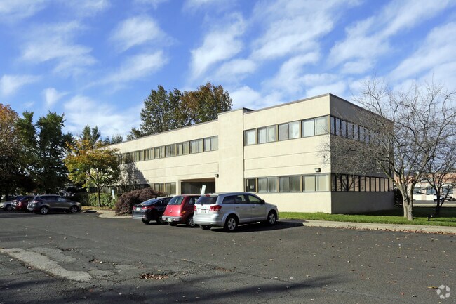
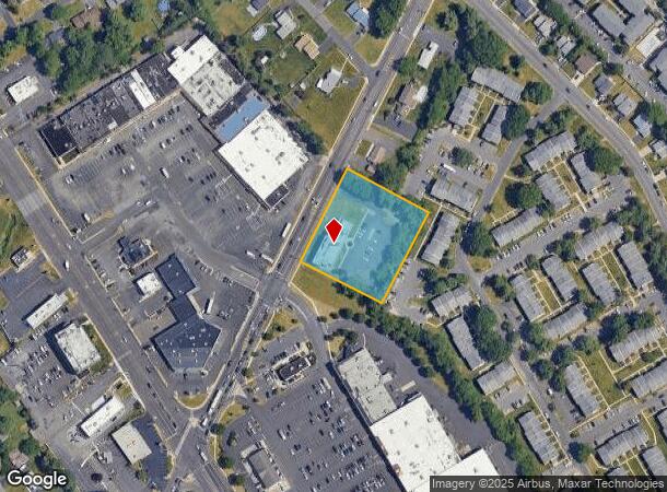
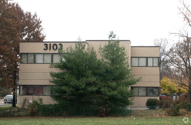
Property Record
3103 Hulmeville Rd, Bensalem, PA 19020
Current Lease Availabilities
NEARBY LISTINGS FOR SALE OR LEASE
Property Detail
3103 Hulmeville Rd
02-033-084
E S SR513 626 N OF SR13 2 280 ON SR513 1.767 7 AC
Medicalbuilding
Bucks
X
Pennsylvania
42017C0502J
7 AC
2024
Lower Bucks County
2025
Philadelphia
100214
Philadelphia-Camden-Wilmington, PA-NJ-DE-MD
6,844 SF
DEMOGRAPHICS near 3103 Hulmeville Rd
1 Mile
3 Mile
5 Mile
2024 Total Population
16,755
98,785
288,738
2029 Population
16,819
97,111
284,384
Pop Growth 2024-2029
+ 0.38%
(1.69%)
(1.51%)
Average Age
40
41
42
2024 Total Households
6,463
37,783
112,284
HH Growth 2024-2029
+ 0.37%
(1.81%)
(1.69%)
Median Household Inc
$59,661
$74,794
$74,511
Avg Household Size
2.50
2.50
2.50
2024 Avg HH Vehicles
2.00
2.00
2.00
Median Home Value
$330,884
$267,716
$265,608
Median Year Built
1971
1968
1967
Nearby Places
Map Layers
Map Styles
 Street
 Aerial
- Restaurants
- Banks
- Shops
- Fitness
- Groceries
PUBLIC TRANSPORTATION
COMMUTER RAIL
Eddington (R7 - Southeastern Pennsylvania Transportation Authority Regional Rail (SEPTA Regional Rail))
DRIVE
WALK
Distance
Eddington (R7 - Southeastern Pennsylvania Transportation Authority Regional Rail (SEPTA Regional Rail))
3 min
1.4 mi
Cornwells Heights (R7 - Southeastern Pennsylvania Transportation Authority Regional Rail (SEPTA Regional Rail))
DRIVE
WALK
Distance
Cornwells Heights (R7 - Southeastern Pennsylvania Transportation Authority Regional Rail (SEPTA Regional Rail))
5 min
2.2 mi
AIRPORT
Trenton Mercer
DRIVE
WALK
Distance
Trenton Mercer
27 min
16.4 mi
Philadelphia International
DRIVE
WALK
Distance
Philadelphia International
41 min
27.2 mi
Freight Ports
Port of Philadelphia
DRIVE
WALK
Distance
Port of Philadelphia
20 min
13.5 mi
Nearby Properties
Address
Land Use
TOTAL SIZE
Lot Size
Zoning
Address
Land Use
TOTAL SIZE
Lot Size
Zoning
34,350 SF
336 AC
SPPOA
Address
Land Use
TOTAL SIZE
Lot Size
Zoning
6,290 SF
177.73 AC
RSA4
Address
Land Use
TOTAL SIZE
Lot Size
Zoning
1,615,457 SF
119.41 AC
CA2
Address
Land Use
TOTAL SIZE
Lot Size
Zoning
410.98 AC
R2
Address
Land Use
TOTAL SIZE
Lot Size
Zoning
283,878 SF
63.36 AC
RSA3
Address
Land Use
TOTAL SIZE
Lot Size
Zoning
438,910 SF
24.42 AC
RSA4
Address
Land Use
TOTAL SIZE
Lot Size
Zoning
404,000 SF
1.08 AC
RM2
Address
Land Use
TOTAL SIZE
Lot Size
Zoning
459,320 SF
18 AC
RM2
Address
Land Use
TOTAL SIZE
Lot Size
Zoning
453,038 SF
34.79 AC
I1
Address
Land Use
TOTAL SIZE
Lot Size
Zoning
300,700 SF
30.41 AC
I1
Address
Land Use
TOTAL SIZE
Lot Size
Zoning
200.39 AC
SPPOP
Address
Land Use
TOTAL SIZE
Lot Size
Zoning
207,500 SF
16.18 AC
I1
Address
Land Use
TOTAL SIZE
Lot Size
Zoning
241,392 SF
24.15 AC
I1
Address
Land Use
TOTAL SIZE
Lot Size
Zoning
179,868 SF
11.70 AC
CA2
Address
Land Use
TOTAL SIZE
Lot Size
Zoning
444,322 SF
27.43 AC
SPINS
Address
Land Use
TOTAL SIZE
Lot Size
Zoning
123,411 SF
12.80 AC
RSD3
Address
Land Use
TOTAL SIZE
Lot Size
Zoning
143,342 SF
9.74 AC
CA1
Address
Land Use
TOTAL SIZE
Lot Size
Zoning
136,315 SF
11.38 AC
CA1
Address
Land Use
TOTAL SIZE
Lot Size
Zoning
234,965 SF
18.36 AC
CA1
Address
Land Use
TOTAL SIZE
Lot Size
Zoning
139,840 SF
6.63 AC
CA1
Address
Land Use
TOTAL SIZE
Lot Size
Zoning
229,183 SF
19.61 AC
I1
Address
Land Use
TOTAL SIZE
Lot Size
Zoning
74,878 SF
8.45 AC
CA1
Address
Land Use
TOTAL SIZE
Lot Size
Zoning
2,660 SF
23 AC
SPPOA
Address
Land Use
TOTAL SIZE
Lot Size
Zoning
154,048 SF
15.74 AC
I1
Address
Land Use
TOTAL SIZE
Lot Size
Zoning
2,700 SF
51.40 AC
SPPOA
Address
Land Use
TOTAL SIZE
Lot Size
Zoning
147,610 SF
9.03 AC
I1
Address
Land Use
TOTAL SIZE
Lot Size
Zoning
160,862 SF
5.93 AC
RM2
Address
Land Use
TOTAL SIZE
Lot Size
Zoning
169,109 SF
20.43 AC
I2
Address
Land Use
TOTAL SIZE
Lot Size
Zoning
131,987 SF
10.56 AC
I1
Address
Land Use
TOTAL SIZE
Lot Size
Zoning
116,000 SF
224.30 AC
SPPOP
The World's #1 Commercial Real Estate Marketplace
Connect with us
© 2026 CoStar Group
The information above has been obtained from sources believed reliable. While we do not doubt its accuracy we have not verified it and make no guarantee, warranty or representation about it. It is your responsibility to independently confirm its accuracy and completeness. Any projections, opinions, assumptions, or estimates used are for example only and do not represent the current or future performance of the property. The value of this transaction to you depends on tax and other factors which should be evaluated by your tax, financial, and legal advisors. You and your advisors should conduct a careful, independent investigation of the property to determine to your satisfaction the suitability of the property for your needs.