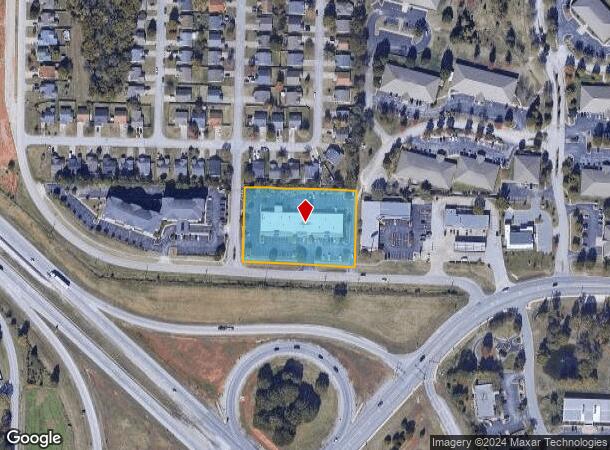
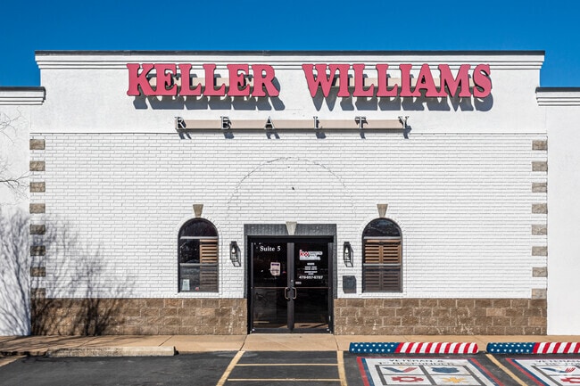
Property Record
3105 Ne 11Th St, Bentonville, AR 72712

NEARBY LISTINGS FOR SALE OR LEASE
Property Detail
3105 Ne 11Th St
Fayetteville-Springdale-Rogers, AR-MO
Dogwood Place-Bentonville
01-07189-000
PLAT 20-270 PLAT 3-698 3/27/01 REPLAT 2003 43
Officebuilding
Benton
X
Arkansas
05007C0095K
3
2025
1.93 AC
2025
Bentonville
020501
Fayetteville/Springdale/Rogers
17,730 SF
DEMOGRAPHICS near 3105 Ne 11Th St
1 Mile
3 Mile
5 Mile
2024 Total Population
3,266
33,082
95,020
2029 Population
3,812
38,845
111,618
Pop Growth 2024-2029
+ 16.72%
+ 17.42%
+ 17.47%
Average Age
37
37
37
2024 Total Households
1,169
13,001
36,373
HH Growth 2024-2029
+ 16.77%
+ 17.58%
+ 17.60%
Median Household Inc
$103,271
$76,344
$77,857
Avg Household Size
2.80
2.50
2.50
2024 Avg HH Vehicles
2.00
2.00
2.00
Median Home Value
$373,188
$289,071
$260,224
Median Year Built
2002
1994
1996
Nearby Places
Map Layers
Map Styles
 Street
 Aerial
- Restaurants
- Banks
- Shops
- Fitness
- Groceries
PUBLIC TRANSPORTATION
AIRPORT
Northwest Arkansas Ntl
DRIVE
WALK
Distance
Northwest Arkansas Ntl
30 min
15.3 mi
SALE & LEASE HISTORY
LISTING DATE
SALE/LEASE

Apr 16, 2020
For Sale
Nearby Properties
Address
Land Use
TOTAL SIZE
Lot Size
Zoning
Address
Land Use
TOTAL SIZE
Lot Size
Zoning
552,541 SF
26.92 AC
Address
Land Use
TOTAL SIZE
Lot Size
Zoning
147,199 SF
16.11 AC
Address
Land Use
TOTAL SIZE
Lot Size
Zoning
344,315 SF
12.74 AC
Address
Land Use
TOTAL SIZE
Lot Size
Zoning
149,727 SF
1.32 AC
Address
Land Use
TOTAL SIZE
Lot Size
Zoning
675,465 SF
37.34 AC
Address
Land Use
TOTAL SIZE
Lot Size
Zoning
381,924 SF
10.23 AC
Address
Land Use
TOTAL SIZE
Lot Size
Zoning
187,529 SF
37.78 AC
Address
Land Use
TOTAL SIZE
Lot Size
Zoning
247,292 SF
1.57 AC
Address
Land Use
TOTAL SIZE
Lot Size
Zoning
746,783 SF
77.03 AC
Address
Land Use
TOTAL SIZE
Lot Size
Zoning
208,865 SF
7.73 AC
Address
Land Use
TOTAL SIZE
Lot Size
Zoning
418,411 SF
26.88 AC
Address
Land Use
TOTAL SIZE
Lot Size
Zoning
256,469 SF
3.18 AC
Address
Land Use
TOTAL SIZE
Lot Size
Zoning
60,250 SF
60.17 AC
Address
Land Use
TOTAL SIZE
Lot Size
Zoning
6,545 SF
29.19 AC
Address
Land Use
TOTAL SIZE
Lot Size
Zoning
97,660 SF
5.35 AC
Address
Land Use
TOTAL SIZE
Lot Size
Zoning
543,020 SF
9.15 AC
Address
Land Use
TOTAL SIZE
Lot Size
Zoning
39,047 SF
1.43 AC
Address
Land Use
TOTAL SIZE
Lot Size
Zoning
64,098 SF
2.17 AC
Address
Land Use
TOTAL SIZE
Lot Size
Zoning
213,552 SF
20.20 AC
Address
Land Use
TOTAL SIZE
Lot Size
Zoning
18,413 SF
0.68 AC
Address
Land Use
TOTAL SIZE
Lot Size
Zoning
176,035 SF
1.48 AC
Address
Land Use
TOTAL SIZE
Lot Size
Zoning
118,875 SF
5.06 AC
Address
Land Use
TOTAL SIZE
Lot Size
Zoning
249,843 SF
19.21 AC
Address
Land Use
TOTAL SIZE
Lot Size
Zoning
239,145 SF
32.91 AC
Address
Land Use
TOTAL SIZE
Lot Size
Zoning
170,184 SF
10.51 AC
Address
Land Use
TOTAL SIZE
Lot Size
Zoning
161,358 SF
12.23 AC
Address
Land Use
TOTAL SIZE
Lot Size
Zoning
31.21 AC
Address
Land Use
TOTAL SIZE
Lot Size
Zoning
152,197 SF
9.99 AC
Address
Land Use
TOTAL SIZE
Lot Size
Zoning
148,317 SF
1.74 AC
Address
Land Use
TOTAL SIZE
Lot Size
Zoning
274,312 SF
12.24 AC
The World's #1 Commercial Real Estate Marketplace
Connect with us
© 2025 CoStar Group
The information above has been obtained from sources believed reliable. While we do not doubt its accuracy we have not verified it and make no guarantee, warranty or representation about it. It is your responsibility to independently confirm its accuracy and completeness. Any projections, opinions, assumptions, or estimates used are for example only and do not represent the current or future performance of the property. The value of this transaction to you depends on tax and other factors which should be evaluated by your tax, financial, and legal advisors. You and your advisors should conduct a careful, independent investigation of the property to determine to your satisfaction the suitability of the property for your needs.