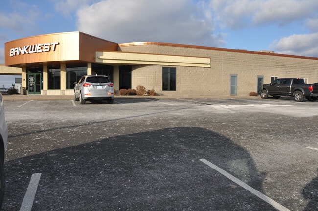
Property Record
311 10Th Ave S, Buffalo, MN 55313

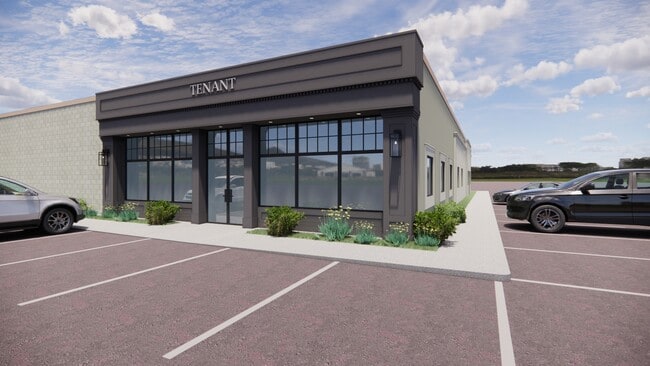
Current Lease Availabilities
Property Detail
311 10Th Ave S
Minneapolis-St. Paul-Bloomington, MN-WI
SECT-29 TWP-120 RANGE-025 HWY 55 EAST COMMERCIAL PARK LOT-006 BLOCK-001 ALSO THAT PART OF VACATED 10TH AVENUE SOUTH DESCRIBED
103-067-001060
Wright
Officebuilding
Minnesota
2026
6
2025
1.07 AC
100704
Wright County
12,632 SF
Minneapolis/St Paul
NEARBY LISTINGS FOR SALE OR LEASE
DEMOGRAPHICS near 311 10Th Ave S
1 mile
3 mile
5 mile
2025 Total Population
4,222
18,363
22,917
2030 Population
4,569
19,693
24,544
Pop Growth 2025-2030
+ 8.22%
+ 7.24%
+ 7.10%
Average Age
40
40
40
2025 Total Households
1,689
6,904
8,453
HH Growth 2025-2030
+ 8.47%
+ 7.40%
+ 7.25%
Median Household Inc
$92,363
$90,714
$94,513
Avg Household Size
2.40
2.60
2.60
2025 Avg HH Vehicles
2.00
2.00
2.00
Median Home Value
$275,793
$318,629
$341,522
Median Year Built
1998
1994
1993
Nearby Places
Map Layers
Map Styles
 Street
 Aerial
Layers
 Traffic
 Biking
Places
Listings with unknown addresses are not visible on the map
- Restaurants
- Banks
- Shops
- Fitness
- Groceries
Nearby Properties
Address
Land Use
TOTAL SIZE
Lot Size
Zoning
Address
Land Use
TOTAL SIZE
Lot Size
Zoning
66.55 AC
Address
Land Use
TOTAL SIZE
Lot Size
Zoning
11.70 AC
Address
Land Use
TOTAL SIZE
Lot Size
Zoning
11.55 AC
Address
Land Use
TOTAL SIZE
Lot Size
Zoning
284,356 SF
12 AC
Address
Land Use
TOTAL SIZE
Lot Size
Zoning
158,379 SF
11.22 AC
Address
Land Use
TOTAL SIZE
Lot Size
Zoning
33.06 AC
Address
Land Use
TOTAL SIZE
Lot Size
Zoning
102,684 SF
17.59 AC
Address
Land Use
TOTAL SIZE
Lot Size
Zoning
195,958 SF
42.67 AC
Address
Land Use
TOTAL SIZE
Lot Size
Zoning
12,888 SF
22.59 AC
Address
Land Use
TOTAL SIZE
Lot Size
Zoning
96,164 SF
5 AC
Address
Land Use
TOTAL SIZE
Lot Size
Zoning
23,489 SF
0.94 AC
Address
Land Use
TOTAL SIZE
Lot Size
Zoning
207,045 SF
22.83 AC
Address
Land Use
TOTAL SIZE
Lot Size
Zoning
6.31 AC
Address
Land Use
TOTAL SIZE
Lot Size
Zoning
19,974 SF
1.37 AC
Address
Land Use
TOTAL SIZE
Lot Size
Zoning
83,446 SF
9.96 AC
Address
Land Use
TOTAL SIZE
Lot Size
Zoning
80,676 SF
3.49 AC
Address
Land Use
TOTAL SIZE
Lot Size
Zoning
160,410 SF
16.63 AC
Address
Land Use
TOTAL SIZE
Lot Size
Zoning
75,112 SF
10.62 AC
Address
Land Use
TOTAL SIZE
Lot Size
Zoning
84,619 SF
5.63 AC
Address
Land Use
TOTAL SIZE
Lot Size
Zoning
29,546 SF
4.75 AC
Address
Land Use
TOTAL SIZE
Lot Size
Zoning
82,384 SF
8.58 AC
Address
Land Use
TOTAL SIZE
Lot Size
Zoning
15.47 AC
Address
Land Use
TOTAL SIZE
Lot Size
Zoning
68,140 SF
3 AC
Address
Land Use
TOTAL SIZE
Lot Size
Zoning
13,173 SF
0.44 AC
Address
Land Use
TOTAL SIZE
Lot Size
Zoning
110,834 SF
13.61 AC
Address
Land Use
TOTAL SIZE
Lot Size
Zoning
76,144 SF
2.71 AC
Address
Land Use
TOTAL SIZE
Lot Size
Zoning
7.20 AC
Address
Land Use
TOTAL SIZE
Lot Size
Zoning
54,792 SF
5.52 AC
Address
Land Use
TOTAL SIZE
Lot Size
Zoning
52,497 SF
16.07 AC
Address
Land Use
TOTAL SIZE
Lot Size
Zoning
21,861 SF
1.46 AC
The World's #1 Commercial Real Estate Marketplace
Connect with us
© 2026 CoStar Group
The information above has been obtained from sources believed reliable. While we do not doubt its accuracy we have not verified it and make no guarantee, warranty or representation about it. It is your responsibility to independently confirm its accuracy and completeness. Any projections, opinions, assumptions, or estimates used are for example only and do not represent the current or future performance of the property. The value of this transaction to you depends on tax and other factors which should be evaluated by your tax, financial, and legal advisors. You and your advisors should conduct a careful, independent investigation of the property to determine to your satisfaction the suitability of the property for your needs.