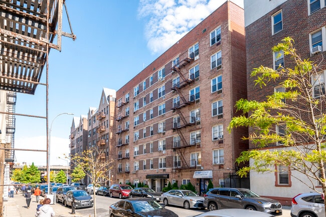
Property Record
3111 Brighton 2Nd St, Brooklyn, NY 11235


NEARBY LISTINGS FOR SALE OR LEASE
Property Detail
3111 Brighton 2Nd St
08685-00834F
Kings
Cooperative
New York
X
83
3604970354F
0.23 AC
0
Brighton Beach
2025
Long Island (New York)
036001
New York-Jersey City-White Plains, NY-NJ
42,700 SF
DEMOGRAPHICS near 3111 Brighton 2Nd St
1 mile
3 mile
5 mile
2024 Total Population
76,884
440,086
1,006,623
2029 Population
72,979
412,219
935,105
Pop Growth 2024-2029
(5.08%)
(6.33%)
(7.10%)
Average Age
47
42
40
2024 Total Households
33,016
160,891
346,841
HH Growth 2024-2029
(5.35%)
(6.69%)
(7.43%)
Median Household Inc
$53,574
$58,879
$64,220
Avg Household Size
2.30
2.60
2.80
2024 Avg HH Vehicles
1.00
1.00
1.00
Median Home Value
$564,159
$747,258
$782,943
Median Year Built
1961
1950
1948
Nearby Places
Map Layers
Map Styles
 Street
 Aerial
Transit
 Traffic
 Biking
Places
Listings with unknown addresses are not visible on the map
- Restaurants
- Banks
- Shops
- Fitness
- Groceries
PUBLIC TRANSPORTATION
TRANSIT/SUBWAY
Ocean Parkway (Q - New York MTA Subway (The Subway))
Drive
Walk
Distance
Ocean Parkway (Q - New York MTA Subway (The Subway))
2 min
5 min
0.2 mi
Brighton Beach (B - New York MTA Subway (The Subway), Q - New York MTA Subway (The Subway))
Drive
Walk
Distance
Brighton Beach (B - New York MTA Subway (The Subway), Q - New York MTA Subway (The Subway))
1 min
5 min
0.3 mi
West 8 Street-New York Aquarium (F - New York MTA Subway (The Subway), Q - New York MTA Subway (The Subway))
Drive
Walk
Distance
West 8 Street-New York Aquarium (F - New York MTA Subway (The Subway), Q - New York MTA Subway (The Subway))
4 min
16 min
0.8 mi
Neptune Avenue (F - New York MTA Subway (The Subway))
Drive
Walk
Distance
Neptune Avenue (F - New York MTA Subway (The Subway))
4 min
17 min
0.9 mi
COMMUTER RAIL
Grasmere (Staten Island Railway - New York MTA Subway (The Subway))
Drive
Walk
Distance
Grasmere (Staten Island Railway - New York MTA Subway (The Subway))
19 min
9.5 mi
Old Town (Staten Island Railway - New York MTA Subway (The Subway))
Drive
Walk
Distance
Old Town (Staten Island Railway - New York MTA Subway (The Subway))
20 min
9.7 mi
AIRPORT
John F Kennedy International
Drive
Walk
Distance
John F Kennedy International
23 min
15.5 mi
LaGuardia
Drive
Walk
Distance
LaGuardia
35 min
22.3 mi
Newark Liberty International
Drive
Walk
Distance
Newark Liberty International
39 min
24.7 mi
Freight Ports
NY - Red Hook Container Terminal
Drive
Walk
Distance
NY - Red Hook Container Terminal
18 min
8.9 mi
Nearby Properties
Address
Land Use
TOTAL SIZE
Lot Size
Zoning
Address
Land Use
TOTAL SIZE
Lot Size
Zoning
200 SF
281.30 AC
R4
Address
Land Use
TOTAL SIZE
Lot Size
Zoning
200 SF
281.30 AC
R4
Address
Land Use
TOTAL SIZE
Lot Size
Zoning
200 SF
281.30 AC
R4
Address
Land Use
TOTAL SIZE
Lot Size
Zoning
200 SF
281.30 AC
R4
Address
Land Use
TOTAL SIZE
Lot Size
Zoning
200 SF
281.30 AC
R4
Address
Land Use
TOTAL SIZE
Lot Size
Zoning
200 SF
281.30 AC
R4
Address
Land Use
TOTAL SIZE
Lot Size
Zoning
200 SF
281.30 AC
R4
Address
Land Use
TOTAL SIZE
Lot Size
Zoning
200 SF
281.30 AC
R4
Address
Land Use
TOTAL SIZE
Lot Size
Zoning
200 SF
281.30 AC
R4
Address
Land Use
TOTAL SIZE
Lot Size
Zoning
200 SF
281.30 AC
R4
Address
Land Use
TOTAL SIZE
Lot Size
Zoning
200 SF
281.30 AC
R4
Address
Land Use
TOTAL SIZE
Lot Size
Zoning
200 SF
281.30 AC
R4
Address
Land Use
TOTAL SIZE
Lot Size
Zoning
200 SF
281.30 AC
R4
Address
Land Use
TOTAL SIZE
Lot Size
Zoning
200 SF
281.30 AC
R4
Address
Land Use
TOTAL SIZE
Lot Size
Zoning
200 SF
281.30 AC
R4
Address
Land Use
TOTAL SIZE
Lot Size
Zoning
200 SF
281.30 AC
R4
Address
Land Use
TOTAL SIZE
Lot Size
Zoning
200 SF
281.30 AC
R4
Address
Land Use
TOTAL SIZE
Lot Size
Zoning
200 SF
281.30 AC
R4
Address
Land Use
TOTAL SIZE
Lot Size
Zoning
200 SF
281.30 AC
R4
Address
Land Use
TOTAL SIZE
Lot Size
Zoning
200 SF
281.30 AC
R4
Address
Land Use
TOTAL SIZE
Lot Size
Zoning
200 SF
281.30 AC
R4
Address
Land Use
TOTAL SIZE
Lot Size
Zoning
200 SF
281.30 AC
R4
Address
Land Use
TOTAL SIZE
Lot Size
Zoning
200 SF
281.30 AC
R4
Address
Land Use
TOTAL SIZE
Lot Size
Zoning
200 SF
281.30 AC
R4
Address
Land Use
TOTAL SIZE
Lot Size
Zoning
200 SF
281.30 AC
R4
Address
Land Use
TOTAL SIZE
Lot Size
Zoning
200 SF
281.30 AC
R4
Address
Land Use
TOTAL SIZE
Lot Size
Zoning
200 SF
281.30 AC
R4
Address
Land Use
TOTAL SIZE
Lot Size
Zoning
200 SF
281.30 AC
R4
Address
Land Use
TOTAL SIZE
Lot Size
Zoning
200 SF
281.30 AC
R4
Address
Land Use
TOTAL SIZE
Lot Size
Zoning
200 SF
281.30 AC
R4
The World's #1 Commercial Real Estate Marketplace
Connect with us
© 2026 CoStar Group
The information above has been obtained from sources believed reliable. While we do not doubt its accuracy we have not verified it and make no guarantee, warranty or representation about it. It is your responsibility to independently confirm its accuracy and completeness. Any projections, opinions, assumptions, or estimates used are for example only and do not represent the current or future performance of the property. The value of this transaction to you depends on tax and other factors which should be evaluated by your tax, financial, and legal advisors. You and your advisors should conduct a careful, independent investigation of the property to determine to your satisfaction the suitability of the property for your needs.